FAA INFORMATION EFFECTIVE 22 JANUARY 2026
Location
| FAA Identifier: | GYY |
| Lat/Long: | 41-37-02.1000N 087-24-52.3000W
41-37.035000N 087-24.871667W
41.6172500,-87.4145278
(estimated) |
| Elevation: | 596.8 ft. / 181.9 m (surveyed) |
| Variation: | 02W (1990) |
| From city: | 3 miles NW of central business district of the associated city |
| Time zone: | UTC -6 (UTC -5 during Daylight Saving Time) |
| Zip code: | 46406 |
Airport Operations
| Airport use: | Open to the public |
| Control tower: | yes |
| ARTCC: | CHICAGO CENTER |
| FSS: | TERRE HAUTE FLIGHT SERVICE STATION |
| NOTAMs facility: | GYY (NOTAM-D service available) |
| Attendance: | CONTINUOUS |
| Wind indicator: | lighted |
| Segmented circle: | no |
| Lights: | WHEN ATCT CLSD ACTVT MALSR RWY 30; REIL RWY 02, 12 & 20; MIRL RWY 02/20; HIRL RWY 12/30 - CTAF. |
| Beacon: | white-green (lighted land airport)
Operates sunset to sunrise. |
| Landing fee: | yes |
| Fire and rescue: | ARFF index A |
| Airline operations: | CLSD TO SKED ACR OPS GTR THAN 9 PAX SEATS; UNSKED ACR OPS GTR THAN 30 PAX SEATS 1 HR PPR; INDEX B ARFF 1 HR PPR; INDEX C ARFF 4 HR PPR - 219-949-4910. |
| International operations: | customs landing rights airport |
Airport Communications
| CTAF: | 125.6 |
| WX AWOS-3PT: | 134.575 (219-944-0010) |
| GARY GROUND: | 121.9 [0500-2200] |
| GARY TOWER: | 125.6 [0500-2200] |
| CHICAGO APPROACH: | 133.1 |
| CHICAGO DEPARTURE: | 133.1 |
| ARNG OPS: | 139.6 245.7 38.3 |
| D-ATIS: | 134.575 |
| LUCIT STAR: | 133.1 |
| WX AWOS-3PT at IGQ (7 nm SW): | 124.925 (708-889-6319) |
| WX ASOS at MDW (18 nm NW): | PHONE 773-884-4424 |
| WX AWOS-AV at C56 (19 nm SW): | 119.125 (708-534-5256) |
- COMMUNICATIONS PRVDD BY TERRE HAUTE RADIO ON FREQ 122.3 (CROWNPOINT RCO).
Nearby radio navigation aids
| VOR radial/distance | | VOR name | | Freq | | Var |
|---|
| CGTr046/9.5 | | CHICAGO HEIGHTS VORTAC | | 114.20 | | 02E |
| EONr037/26.9 | | PEOTONE VORTAC | | 113.20 | | 02E |
Airport Services
| Fuel available: | 100LL JET-A |
| Parking: | hangars and tiedowns |
| Airframe service: | MAJOR |
| Powerplant service: | MAJOR |
| Bottled oxygen: | HIGH |
Runway Information
Runway 12/30
| Dimensions: | 8859 x 150 ft. / 2700 x 46 m |
| Surface: | concrete/grooved, in good condition |
| Weight bearing capacity: | | Single wheel: | 75.0 | | Double wheel: | 157.0 | | Double tandem: | 175.0 | | Dual double tandem: | 250.0 |
|
| Runway edge lights: | high intensity |
| RUNWAY 12 | | RUNWAY 30 |
| Latitude: | 41-37.452325N | | 41-36.633260N |
| Longitude: | 087-25.639297W | | 087-24.030777W |
| Elevation: | 596.8 ft. | | 591.3 ft. |
| Traffic pattern: | left | | left |
| Runway heading: | 126 magnetic, 124 true | | 306 magnetic, 304 true |
| Displaced threshold: | no | | 900 ft. |
| Declared distances: | TORA:8859 TODA:8859 ASDA:7959 LDA:7959 | | TORA:8859 TODA:8859 ASDA:8859 LDA:7959 |
| Markings: | precision, in good condition | | precision, in good condition |
| Visual slope indicator: | 4-light PAPI on left (3.00 degrees glide path) | | 4-light PAPI on left (3.00 degrees glide path) |
| RVR equipment: | rollout | | touchdown |
| Approach lights: | | | MALSR: 1,400 foot medium intensity approach lighting system with runway alignment indicator lights |
| Runway end identifier lights: | yes | | no |
| Centerline lights: | yes | | yes |
| Touchdown point: | yes, no lights | | yes, no lights |
| Instrument approach: | | | ILS/DME |
| Obstructions: | 93 ft. ant, 3777 ft. from runway, 1248 ft. left of centerline, 38:1 slope to clear | | 68 ft. pole, lighted, 3422 ft. from runway, 220 ft. left of centerline, 47:1 slope to clear |
Runway 2/20
| Dimensions: | 3604 x 100 ft. / 1098 x 30 m |
| Surface: | asphalt, in fair condition |
| Weight bearing capacity: | | Single wheel: | 18.0 | | Double wheel: | 28.0 |
|
| Runway edge lights: | medium intensity |
| Operational restrictions: | RWY 02/20 NOT AVBL FOR PART 121/PART 380 OPS WITH SKED PAX CARRYING OPS MORE THAN 9 PAX SEATS AND NON-SKED PAX CARRYING OPS MORE THAN 30 PAX SEATS. |
| RUNWAY 2 | | RUNWAY 20 |
| Latitude: | 41-36.736938N | | 41-37.290240N |
| Longitude: | 087-25.104925W | | 087-24.819187W |
| Elevation: | 589.1 ft. | | 589.3 ft. |
| Traffic pattern: | left | | left |
| Runway heading: | 023 magnetic, 021 true | | 203 magnetic, 201 true |
| Declared distances: | TORA:3604 TODA:3604 ASDA:3604 LDA:3604 | | TORA:3604 TODA:3604 ASDA:3604 LDA:3604 |
| Markings: | nonprecision, in good condition | | nonprecision, in good condition |
| Visual slope indicator: | 2-light PAPI on left (3.00 degrees glide path) | | 2-light PAPI on left (3.00 degrees glide path) |
| Runway end identifier lights: | yes | | yes |
| Touchdown point: | yes, no lights | | yes, no lights |
| Obstructions: | 42 ft. road, 1050 ft. from runway, 20:1 slope to clear | | 37 ft. pole, 833 ft. from runway, 289 ft. right of centerline, 17:1 slope to clear |
Airport Ownership and Management from official FAA records
| Ownership: | Publicly-owned |
| Owner: | GARY/CHICAGO ARPT AUTH DIST
6001 INDUSTRIAL HWY
GARY, IN 46406
Phone 219-949-9722 |
| Manager: | DANIEL VICARI
6001-C AIRPORT RD
GARY, IN 46406
Phone 219-949-4925 |
Additional Remarks
| A39-12/30 | PCR VALUE: 706/R/C/X/U |
| A39-02/20 | PCR VALUE: 121/R/C/X/U |
| - | BIRDS & WILDLIFE ON & INVOF ARPT. |
| - | UNCTLD VEHICLES N SIDE RAMPS. |
| - | TWY A, A1-A8 & C NORTH OF RWY 12/30 AVBL TO ACR MORE THAN 9 PAX SEATS. |
| - | TWY F MIL USE ONLY. |
| - | LINE OF SIGHT NA BTN INTERSECTING RWY ENDS. |
| - | ARNG: OPS 1230Z-2330Z++ TUES-FRI. MIL F/W OR R/W PRKG OR SVC ON ARNG RAMP 24 HR PPR - 219-977-2017. |
| - | FOR CD WHEN ATCT IS CLSD CTC CHICAGO APCH AT 847-289-0926. |
Instrument Procedures
NOTE: All procedures below are presented as PDF files. If you need a reader for these files, you should download the free Adobe Reader.NOT FOR NAVIGATION. Please procure official charts for flight.
FAA instrument procedures published for use from 22 January 2026 at 0901Z to 19 February 2026 at 0900z.
STARs - Standard Terminal Arrivals |
|---|
| LUCIT THREE (RNAV) **CHANGED** | |
2 pages:
[1] [2] (343KB) |
| PANGG SEVEN (RNAV) **CHANGED** | |
2 pages:
[1] [2] (444KB) |
IAPs - Instrument Approach Procedures |
|---|
| ILS OR LOC RWY 30 **CHANGED** | |
download (307KB) |
| RNAV (RNP) Z RWY 12 **CHANGED** | |
download (219KB) |
| RNAV (RNP) Z RWY 30 **CHANGED** | |
download (211KB) |
| RNAV (GPS) RWY 02 **CHANGED** | |
download (254KB) |
| RNAV (GPS) RWY 20 **CHANGED** | |
download (202KB) |
| RNAV (GPS) Y RWY 12 **CHANGED** | |
download (222KB) |
| RNAV (GPS) Y RWY 30 **CHANGED** | |
download (249KB) |
| COPTER ILS OR LOC RWY 30 **CHANGED** | |
download (245KB) |
| NOTE: Special Alternate Minimums apply | |
download (169KB) |
Departure Procedures |
|---|
| ADELL SEVEN (RNAV) **CHANGED** | |
download (211KB) |
| BLOKR SEVEN (RNAV) **CHANGED** | |
download (220KB) |
| CARYN SEVEN (RNAV) **CHANGED** | |
download (201KB) |
| DARCY SEVEN (RNAV) **CHANGED** | |
download (220KB) |
| ELANR EIGHT (RNAV) **CHANGED** | |
download (243KB) |
| NOTE: Special Take-Off Minimums/Departure Procedures apply | |
download (478KB) |
Other nearby airports with instrument procedures:
05C - Griffith-Merrillville Airport (6 nm S)
KIGQ - Lansing Municipal Airport (7 nm SW)
3HO - Hobart Sky Ranch Airport (8 nm SE)
KMDW - Chicago Midway International Airport (18 nm NW)
C56 - Bult Field Airport (19 nm SW)
|
|

Road maps at:
MapQuest
Bing
Google
| Aerial photo |
|---|
WARNING: Photo may not be current or correct
 Photo taken 25-Jun-2015
looking southeast.
Photo taken 25-Jun-2015
looking southeast.
Do you have a better or more recent aerial photo of Gary/Chicago International Airport that you would like to share? If so, please send us your photo.
|
| Sectional chart |
|---|
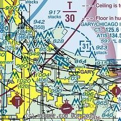
|
CAUTION: Diagram may not be current
 Download PDF
of official airport diagram from the FAA
| Airport distance calculator |
|---|
|
|
| Sunrise and sunset |
|---|
|
Times for 02-Feb-2026
| | Local
(UTC-6) | | Zulu
(UTC) |
|---|
| Morning civil twilight | | 06:32 | | 12:32 |
| Sunrise | | 07:02 | | 13:02 |
| Sunset | | 17:05 | | 23:05 |
| Evening civil twilight | | 17:35 | | 23:35 |
|
| Current date and time |
|---|
| Zulu (UTC) | 02-Feb-2026 13:53:42 |
|---|
| Local (UTC-6) | 02-Feb-2026 07:53:42 |
|---|
|
| METAR |
|---|
| KGYY | 021245Z 23005KT 3SM BR OVC010 M05/M05 A3008
|
KIGQ
7nm SW | 021335Z AUTO 24005KT 5SM BR OVC006 M05/M06 A3011 RMK AO2 T10501062
|
KMDW
18nm NW | 021253Z 24007KT 7SM OVC007 M05/M07 A3008 RMK AO2 FZDZE35 SLP201 P0000 I1000 T10501067
|
|
| TAF |
|---|
| KGYY | 021120Z 0212/0312 24009KT P6SM OVC015 TEMPO 0212/0213 -FZDZ FM021600 29010KT P6SM BKN020 FM030100 30005KT P6SM SCT025 BKN090 PROB30 0307/0311 5SM -SN BKN025
|
KMDW
18nm NW | 021120Z 0212/0318 24009KT P6SM OVC009 TEMPO 0212/0213 -FZDZ FM021400 28009KT P6SM OVC012 FM021800 29010KT P6SM BKN020 FM030000 30005KT P6SM SCT025 BKN090 PROB30 0307/0311 6SM -SN BKN025 FM031100 35007KT P6SM FEW025 FEW150
|
|
| NOTAMs |
|---|
NOTAMs are issued by the DoD/FAA and will open in a separate window not controlled by AirNav.
|
|


