FAA INFORMATION EFFECTIVE 19 FEBRUARY 2026
Location
| FAA Identifier: | HGR |
| Lat/Long: | 39-42-30.6000N 077-43-35.4000W
39-42.510000N 077-43.590000W
39.7085000,-77.7265000
(estimated) |
| Elevation: | 703.1 ft. / 214.3 m (surveyed) |
| Variation: | 11W (2015) |
| From city: | 4 miles N of HAGERSTOWN, MD |
| Time zone: | UTC -5 (UTC -4 during Daylight Saving Time) |
| Zip code: | 21742 |
Airport Operations
| Airport use: | Open to the public |
| Activation date: | 04/1940 |
| Control tower: | yes |
| ARTCC: | WASHINGTON CENTER |
| FSS: | LEESBURG FLIGHT SERVICE STATION |
| NOTAMs facility: | HGR (NOTAM-D service available) |
| Attendance: | 0500-2200
AP UNATTND 2200-0500. |
| Wind indicator: | lighted |
| Segmented circle: | no |
| Lights: | WHEN ATCT CLSD ACTVT MALSR RWY 27; REIL RWY 09; HIRL RWY 09/27 - CTAF. |
| Beacon: | white-green (lighted land airport)
Operates sunset to sunrise. |
| Landing fee: | yes |
| Fire and rescue: | ARFF index B |
| Airline operations: | ARFF INDEX C AVBL UPON REQ; CTC AMGR.
PPR 24 HRS FOR UNSKED ACR OPNS WITH MORE THAN 30 PSGR SEATS CALL AMGR 240-313-2764. |
Airport Communications
| CTAF: | 120.3 |
| UNICOM: | 122.95 |
| WX ASOS: | 126.375 (301-745-3497) |
| HAGERSTOWN GROUND: | 120.8 [0700-2200] |
| HAGERSTOWN TOWER: | 120.3 225.4 [0700-2200] |
| POTOMAC APPROACH: | 126.825 |
| POTOMAC DEPARTURE: | 126.825 |
| AR OPS: | 32.3FM |
| EMERG: | 121.5 243.0 |
| TRSTN STAR: | 126.75 |
| WX AWOS-3 at N68 (16 nm N): | 120.725 (717-261-1943) |
Nearby radio navigation aids
| VOR radial/distance | | VOR name | | Freq | | Var |
|---|
| HGRr091/(6.0) | | HAGERSTOWN VOR | | 109.80 | | 07W |
| MRBr023/20.2 | | MARTINSBURG VORTAC | | 112.10 | | 07W |
| FDKr326/24.1 | | FREDERICK VOR/DME | | 116.85 | | 08W |
| EMIr298/36.9 | | WESTMINSTER VORTAC | | 117.90 | | 08W |
Airport Services
| Fuel available: | 100LL JET-A
100LL:FUEL AVBL 0500-2200 CALL 301-791-9119. DOD CONTRACT FUEL AVBL. |
| Parking: | hangars and tiedowns |
| Airframe service: | MAJOR |
| Powerplant service: | MAJOR |
| Bottled oxygen: | HIGH/LOW |
| Bulk oxygen: | HIGH/LOW |
Runway Information
Runway 9/27
| Dimensions: | 7000 x 150 ft. / 2134 x 46 m |
| Surface: | asphalt/grooved, in good condition |
| Weight bearing capacity: | | Single wheel: | 120.0 | | Double wheel: | 250.0 | | Double tandem: | 550.0 |
|
| Runway edge lights: | high intensity |
| RUNWAY 9 | | RUNWAY 27 |
| Latitude: | 39-42.417728N | | 39-42.607907N |
| Longitude: | 077-44.302543W | | 077-42.830297W |
| Elevation: | 664.4 ft. | | 685.5 ft. |
| Traffic pattern: | left | | left |
| Runway heading: | 092 magnetic, 081 true | | 272 magnetic, 261 true |
| Declared distances: | TORA:7000 TODA:7000 ASDA:7000 LDA:7000 | | TORA:7000 TODA:7000 ASDA:7000 LDA:7000 |
| Markings: | precision, in good condition | | precision, in good condition |
| Visual slope indicator: | 4-light PAPI on left (3.00 degrees glide path) | | 4-light PAPI on left (3.00 degrees glide path) |
| Approach lights: | | | MALSR: 1,400 foot medium intensity approach lighting system with runway alignment indicator lights |
| Runway end identifier lights: | yes | | |
| Touchdown point: | yes, no lights | | yes, no lights |
| Instrument approach: | ILS/DME | | ILS/DME |
Runway 2/20
| Dimensions: | 3165 x 100 ft. / 965 x 30 m |
| Surface: | asphalt, in good condition |
| Weight bearing capacity: | | Single wheel: | 120.0 | | Double wheel: | 250.0 | | Double tandem: | 515.0 |
|
| Runway edge lights: | medium intensity |
| Operational restrictions: | RWY 02/20 NOT AVBL FOR PART 121/PART 380 OPS WITH SKED PAX CARRYING OPS MORE THAN 9 PAX SEATS AND NON-SKED PAX CARRYING OPS MORE THAN 30 PAX SEATS. NO PART 121/PART 380 OPS EXC FOR TAX. |
| RUNWAY 2 | | RUNWAY 20 |
| Latitude: | 39-42.251515N | | 39-42.755368N |
| Longitude: | 077-43.726447W | | 077-43.553388W |
| Elevation: | 692.0 ft. | | 702.9 ft. |
| Traffic pattern: | left | | left |
| Runway heading: | 026 magnetic, 015 true | | 206 magnetic, 195 true |
| Declared distances: | TORA:3165 TODA:3165 ASDA:3165 LDA:3165 | | TORA:3165 TODA:3165 ASDA:3165 LDA:3165 |
| Markings: | basic, in good condition | | basic, in good condition |
| Visual slope indicator: | 2-light PAPI on left (4.00 degrees glide path) | | 2-light PAPI on left (4.00 degrees glide path) |
| Runway end identifier lights: | yes | | yes |
| Touchdown point: | yes, no lights | | yes, no lights |
Airport Ownership and Management from official FAA records
| Ownership: | Publicly-owned |
| Owner: | WASHINGTON COUNTY
100 WEST WASHINGTON ST
HAGERSTOWN, MD 21740
Phone 240-313-2200 |
| Manager: | NEIL DORAN
18434 SHOWALTER RD
HAGERSTOWN, MD 21742
Phone 240-313-2764 |
Additional Remarks
| A39-09/27 | PCR VALUE: 750/F/A/X/T |
| A39-02/20 | PCR VALUE: 600/F/A/X/T |
| - | RWY 02 & 20 CLSD WHEN ATCT CLSD. |
| - | FOR CD WHEN ATCT IS CLSD CTC POTOMAC APCH AT 866-709-4993. |
| - | PPR 24 HR PRIOR TO ACES THE MUSEUM APN. FOR MORE INFO CTC MUSEUM MGR AT 240-520-3417. |
| - | BIRDS ON & INVOF ARPT. |
| - | LOW LEVEL MIL ACFT 10 NM NORTH ON VR708 OPERATING EAST TO WEST. |
| - | ULTRALIGHT ACT 12 NM EAST TO 5000 FT MSL. |
| - | TWY "P" NOT AVBL FOR AIR CARRIER OPS. |
Instrument Procedures
NOTE: All procedures below are presented as PDF files. If you need a reader for these files, you should download the free Adobe Reader.NOT FOR NAVIGATION. Please procure official charts for flight.
FAA instrument procedures published for use from 19 February 2026 at 0901Z to 19 March 2026 at 0900Z.
STARs - Standard Terminal Arrivals |
|---|
| TRSTN FOUR (RNAV) | |
2 pages:
[1] [2] (319KB) |
IAPs - Instrument Approach Procedures |
|---|
| ILS OR LOC RWY 09 | |
download (278KB) |
| ILS OR LOC RWY 27 | |
download (272KB) |
| RNAV (GPS) RWY 09 | |
download (215KB) |
| RNAV (GPS) RWY 27 | |
download (208KB) |
| VOR RWY 09 | |
download (192KB) |
| COPTER RNAV (GPS) RWY 09 | |
download (208KB) |
| COPTER RNAV (GPS) RWY 27 | |
download (213KB) |
| NOTE: Special Alternate Minimums apply | |
download (166KB) |
| NOTE: Special Take-Off Minimums/Departure Procedures apply | |
download (357KB) |
Other nearby airports with instrument procedures:
N68 - Franklin County Regional Airport (16 nm N)
W35 - Potomac Airpark (20 nm W)
KMRB - Eastern WV Regional Airport/Shepherd Field (22 nm SW)
W05 - Gettysburg Regional Airport (22 nm E)
KFDK - Frederick Municipal Airport (24 nm SE)
|
|

Road maps at:
MapQuest
Bing
Google
| Aerial photo |
|---|
WARNING: Photo may not be current or correct
 Photo taken 30-Aug-2016
looking north.
Photo taken 30-Aug-2016
looking north.
Do you have a better or more recent aerial photo of Hagerstown Regional Airport-Richard A Henson Field that you would like to share? If so, please send us your photo.
|
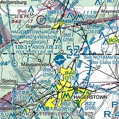
| Sectional chart |
|---|
|
CAUTION: Diagram may not be current
 Download PDF
of official airport diagram from the FAA
| Airport distance calculator |
|---|
|
|
| Sunrise and sunset |
|---|
|
Times for 10-Mar-2026
| | Local
(UTC-4) | | Zulu
(UTC) |
|---|
| Morning civil twilight | | 07:04 | | 11:04 |
| Sunrise | | 07:31 | | 11:31 |
| Sunset | | 19:11 | | 23:11 |
| Evening civil twilight | | 19:38 | | 23:38 |
|
| Current date and time |
|---|
| Zulu (UTC) | 10-Mar-2026 06:04:08 |
|---|
| Local (UTC-4) | 10-Mar-2026 02:04:08 |
|---|
|
| METAR |
|---|
| KHGR | 100553Z AUTO 16005KT 10SM CLR 12/04 A3000 RMK AO2 SLP167 T01170044 10183 20111 50002 $
|
|
| TAF |
|---|
KMRB
22nm SW | 100143Z 1002/1024 24005KT P6SM FEW060
|
|
| NOTAMs |
|---|
NOTAMs are issued by the DoD/FAA and will open in a separate window not controlled by AirNav.
|
|


