FAA INFORMATION EFFECTIVE 16 APRIL 2026
Location
| FAA Identifier: | HRL |
| Lat/Long: | 26-13-35.6140N 097-39-19.1230W
26-13.593567N 097-39.318717W
26.2265594,-97.6553119
(estimated) |
| Elevation: | 36.3 ft. / 11.1 m (surveyed) |
| Variation: | 03E (2025) |
| From city: | 3 miles NE of HARLINGEN, TX |
| Time zone: | UTC -5 (UTC -6 during Standard Time) |
| Zip code: | 78550 |
Airport Operations
| Airport use: | Open to the public |
| Activation date: | 07/1943 |
| Control tower: | yes |
| ARTCC: | HOUSTON CENTER |
| FSS: | SAN ANGELO FLIGHT SERVICE STATION |
| NOTAMs facility: | HRL (NOTAM-D service available) |
| Attendance: | 0600-0000 |
| Wind indicator: | lighted |
| Segmented circle: | yes |
| Lights: | DUSK-DAWN. WHEN ATCT CLSD ACTVT MALSR RWY 18R, RWY 31, RWY 36L - CTAF. |
| Beacon: | white-green (lighted land airport)
Operates sunset to sunrise. |
| Fire and rescue: | ARFF index B |
| Airline operations: | ARFF INDEX C AVAILABLE. PPR FOR ACR ACFT GREATER THAN 126 FEET IN LENGTH CALL 956-430-8605. |
| International operations: | US CUSTOMS USER FEE ARPT. |
Airport Communications
| CTAF: | 119.3 |
| UNICOM: | 122.95 |
| ATIS: | 124.85 |
| WX ASOS: | 124.85 (956-428-7297) |
| HARLINGEN GROUND: | 121.7 [0600-0000] |
| HARLINGEN TOWER: | 119.3 317.6 [0600-0000] |
| VALLEY APPROACH: | 120.7 |
| VALLEY DEPARTURE: | 120.7 |
| CLASS C: | 120.7 |
| WX ASOS at PIL (17 nm E): | 118.525 (956-233-1954) |
| WX AWOS-3PT at TXW (17 nm W): | 118.575 (956-447-0414) |
Nearby radio navigation aids
| VOR radial/distance | | VOR name | | Freq | | Var |
|---|
| HRL at field | | HARLINGEN VOR/DME | | 113.65 | | 05E |
| BROr311/23.6 | | BROWNSVILLE VORTAC | | 116.30 | | 09E |
| MAMr341/28.2 | | MATAMOROS VOR/DME | | 114.30 | | 04E |
| MFEr075/31.7 | | MC ALLEN VOR/DME | | 117.20 | | 09E |
| REXr059/33.7 | | REYNOSA VOR/DME | | 112.40 | | 08E |
Airport Services
| Fuel available: | 100LL JET-A |
| Parking: | hangars and tiedowns |
| Airframe service: | MAJOR |
| Powerplant service: | MAJOR |
| Bottled oxygen: | HIGH |
Runway Information
Runway 18R/36L
| Dimensions: | 9400 x 150 ft. / 2865 x 46 m |
| Surface: | asphalt/grooved, in good condition |
| Weight bearing capacity: | | Single wheel: | 160.0 | | Double wheel: | 200.0 | | Double tandem: | 350.0 | | Dual double tandem: | 700.0 |
|
| Runway edge lights: | high intensity |
| RUNWAY 18R | | RUNWAY 36L |
| Latitude: | 26-14.423010N | | 26-12.871397N |
| Longitude: | 097-39.514252W | | 097-39.533538W |
| Elevation: | 34.0 ft. | | 35.5 ft. |
| Traffic pattern: | right | | left |
| Runway heading: | 178 magnetic, 181 true | | 358 magnetic, 001 true |
| Declared distances: | TORA:9400 TODA:9400 ASDA:9400 LDA:9400 | | TORA:9400 TODA:9400 ASDA:9400 LDA:9400 |
| Markings: | precision, in good condition | | precision, in good condition |
| Visual slope indicator: | 4-light PAPI on left (3.00 degrees glide path) | | 4-light PAPI on right (3.00 degrees glide path) |
| RVR equipment: | touchdown, midfield, rollout | | touchdown, midfield, rollout |
| Approach lights: | MALSR: 1,400 foot medium intensity approach lighting system with runway alignment indicator lights | | MALSR: 1,400 foot medium intensity approach lighting system with runway alignment indicator lights |
| Touchdown point: | yes, no lights | | yes, no lights |
| Instrument approach: | ILS/DME | | ILS/DME |
Runway 13/31
| Dimensions: | 7257 x 150 ft. / 2212 x 46 m |
| Surface: | asphalt/grooved, in good condition |
| Weight bearing capacity: | | Single wheel: | 160.0 | | Double wheel: | 200.0 | | Double tandem: | 350.0 | | Dual double tandem: | 700.0 |
|
| Runway edge lights: | high intensity |
| RUNWAY 13 | | RUNWAY 31 |
| Latitude: | 26-13.991080N | | 26-13.134688N |
| Longitude: | 097-39.837972W | | 097-38.909237W |
| Elevation: | 34.4 ft. | | 35.7 ft. |
| Traffic pattern: | left | | left |
| Runway heading: | 133 magnetic, 136 true | | 313 magnetic, 316 true |
| Declared distances: | TORA:7257 TODA:7257 ASDA:7257 LDA:7257 | | TORA:7257 TODA:7257 ASDA:7257 LDA:7257 |
| Markings: | precision, in good condition | | precision, in good condition |
| Visual slope indicator: | 4-light PAPI on left (3.00 degrees glide path) | | 4-light PAPI on left (3.00 degrees glide path) |
| Approach lights: | | | MALSR: 1,400 foot medium intensity approach lighting system with runway alignment indicator lights |
| Runway end identifier lights: | yes | | |
| Touchdown point: | yes, no lights | | yes, no lights |
Runway 18L/36R
| Dimensions: | 5950 x 150 ft. / 1814 x 46 m |
| Surface: | asphalt, in good condition |
| Weight bearing capacity: | | Single wheel: | 160.0 | | Double wheel: | 200.0 | | Double tandem: | 350.0 |
|
| Runway edge lights: | medium intensity |
| RUNWAY 18L | | RUNWAY 36R |
| Latitude: | 26-14.037163N | | 26-13.055203N |
| Longitude: | 097-38.921503W | | 097-38.933640W |
| Elevation: | 33.7 ft. | | 35.0 ft. |
| Traffic pattern: | left | | right |
| Runway heading: | 178 magnetic, 181 true | | 358 magnetic, 001 true |
| Displaced threshold: | no | | 190 ft. |
| Declared distances: | TORA:5949 TODA:5949 ASDA:5949 LDA:5949 | | TORA:5949 TODA:5949 ASDA:5949 LDA:5759 |
| Markings: | precision, in good condition | | precision, in good condition |
| Visual slope indicator: | 4-light PAPI on left (3.00 degrees glide path)
UNUSBL BYD 7 DEGS RIGHT OF CNTRLN. | | |
| Runway end identifier lights: | yes | | |
| Touchdown point: | yes, no lights | | yes, no lights |
Airport Ownership and Management from official FAA records
| Ownership: | Publicly-owned |
| Owner: | CITY OF HARLINGEN
PO BOX 2207
HARLINGEN, TX 78550-2207
Phone (956) 430-8605 |
| Manager: | MARV ESTERLY
AIRPORT TERMINAL BUILDING,, 3002 HE, 3200 HERITAGE WAY
HARLINGEN, TX 78550
Phone 956-430-8605 |
Additional Remarks
| A39-18R/36L | PCR VALUE: 380/F/D/X/T |
| A39-18L/36R | PCR VALUE: 210/R/B/W/T |
| A39-13/31 | PCR VALUE: 310/F/D/X/T |
| - | MIGRATORY BIRDS ON & INVOF ARPT. |
| - | WHEN ATCT CLSD REQ ARFF THRU CORPUS APPROACH OR FLT SVC. |
| - | FOR CD WHEN ATCT IS CLSD CTC CRP APCH AT 361-299-4230. |
Instrument Procedures
NOTE: All procedures below are presented as PDF files. If you need a reader for these files, you should download the free Adobe Reader.NOT FOR NAVIGATION. Please procure official charts for flight.
FAA instrument procedures published for use from 16 April 2026 at 0901Z to 14 May 2026 at 0900Z.
IAPs - Instrument Approach Procedures |
|---|
| ILS OR LOC RWY 18R | |
download (278KB) |
| ILS OR LOC RWY 36L | |
download (273KB) |
| ILS RWY 18R (SA CAT I - II) | |
download (222KB) |
| ILS RWY 36L (SA CAT I - II) | |
download (224KB) |
| RNAV (RNP) Z RWY 13 | |
download (208KB) |
| RNAV (RNP) Z RWY 18R | |
download (234KB) |
| RNAV (RNP) Z RWY 31 | |
download (220KB) |
| RNAV (RNP) Z RWY 36L | |
download (241KB) |
| RNAV (GPS) RWY 18L | |
download (268KB) |
| RNAV (GPS) RWY 36R | |
download (234KB) |
| RNAV (GPS) Y RWY 13 | |
download (247KB) |
| RNAV (GPS) Y RWY 18R | |
download (305KB) |
| RNAV (GPS) Y RWY 31 | |
download (289KB) |
| RNAV (GPS) Y RWY 36L | |
download (255KB) |
| VOR RWY 18L | |
download (239KB) |
| VOR RWY 18R **CHANGED** | |
download (268KB) |
| VOR RWY 36L | |
download (238KB) |
| VOR Y OR TACAN RWY 31 | |
download (234KB) |
| VOR Z RWY 31 | |
download (265KB) |
| NOTE: Special Alternate Minimums apply | |
download (139KB) |
| NOTE: Special Take-Off Minimums/Departure Procedures apply | |
download (299KB) |
Other nearby airports with instrument procedures:
KPIL - Cameron County Airport (17 nm E)
KTXW - Mid Valley Airport (17 nm W)
KBRO - Brownsville/South Padre Island International Airport (23 nm SE)
KEBG - South Texas International Airport at Edinburg (28 nm NW)
KMFE - Mc Allen International Airport (32 nm W)
|
|

Road maps at:
MapQuest
Bing
Google
| Aerial photo |
|---|
WARNING: Photo may not be current or correct

Do you have a better or more recent aerial photo of Valley International Airport that you would like to share? If so, please send us your photo.
|
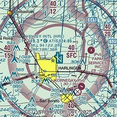
| Sectional chart |
|---|
|
CAUTION: Diagram may not be current
 Download PDF
of official airport diagram from the FAA
| Airport distance calculator |
|---|
|
|
| Sunrise and sunset |
|---|
|
Times for 02-May-2026
| | Local
(UTC-5) | | Zulu
(UTC) |
|---|
| Morning civil twilight | | 06:29 | | 11:29 |
| Sunrise | | 06:53 | | 11:53 |
| Sunset | | 20:02 | | 01:02 |
| Evening civil twilight | | 20:26 | | 01:26 |
|
| Current date and time |
|---|
| Zulu (UTC) | 02-May-2026 12:55:41 |
|---|
| Local (UTC-5) | 02-May-2026 07:55:41 |
|---|
|
| METAR |
|---|
| KHRL | 021220Z 34013KT 10SM OVC010 16/14 A3004 RMK AO2 T01560139 $
|
KTXW
17nm W | 021215Z AUTO 33011KT 10SM OVC013 16/13 A3006 RMK AO2 T01590130
|
KPIL
18nm E | 021153Z AUTO 33019KT 10SM OVC007 16/15 A2999 RMK AO2 PK WND 34026/1129 RAE51 SLP154 P0000 60001 70001 T01610150 10189 20161 51019
|
|
| TAF |
|---|
| KHRL | 021120Z 0212/0312 35016G26KT P6SM BKN013 FM021900 36015G25KT P6SM BKN022 FM022100 01014G24KT P6SM BKN035 FM030200 03009KT P6SM FEW045 FM030600 VRB04KT P6SM FEW035
|
|
| NOTAMs |
|---|
NOTAMs are issued by the DoD/FAA and will open in a separate window not controlled by AirNav.
|
|


