FAA INFORMATION EFFECTIVE 09 JULY 2026
Location
| FAA Identifier: | PIL |
| Lat/Long: | 26-09-58.3000N 097-20-45.2000W
26-09.971667N 097-20.753333W
26.1661944,-97.3458889
(estimated) |
| Elevation: | 18.6 ft. / 5.7 m (surveyed) |
| Variation: | 05E (2010) |
| From city: | 10 miles NW of PORT ISABEL, TX |
| Time zone: | UTC -5 (UTC -6 during Standard Time) |
| Zip code: | 78566 |
Airport Operations
| Airport use: | Open to the public |
| Activation date: | 10/1943 |
| Control tower: | no |
| ARTCC: | HOUSTON CENTER |
| FSS: | SAN ANGELO FLIGHT SERVICE STATION |
| NOTAMs facility: | PIL (NOTAM-D service available) |
| Attendance: | 0800-1700 |
| Wind indicator: | yes |
| Segmented circle: | yes |
| Lights: | SS-SR |
| Beacon: | white-green (lighted land airport)
Operates sunset to sunrise. |
Airport Communications
| CTAF/UNICOM: | 122.8 |
| WX ASOS: | 118.525 (956-233-1954) |
| VALLEY APPROACH: | 119.5 |
| VALLEY DEPARTURE: | 119.5 |
| CLEARANCE DELIVERY: | 119.2 |
| WX ASOS at BRO (16 nm S): | 128.55 (956-299-5871) |
| WX ASOS at HRL (17 nm W): | 124.85 (956-428-7297) |
Nearby radio navigation aids
| VOR radial/distance | | VOR name | | Freq | | Var |
|---|
| BROr357/14.6 | | BROWNSVILLE VORTAC | | 116.30 | | 09E |
| HRLr098/16.9 | | HARLINGEN VOR/DME | | 113.65 | | 05E |
| MAMr018/25.6 | | MATAMOROS VOR/DME | | 114.30 | | 04E |
| NDB name | | Hdg/Dist | | Freq | | Var | | ID |
|---|
| DEPOO | | 036/14.0 | | 393 | | 03E | | BR | -... .-. |
Airport Services
| Fuel available: | 100LL JET-A
100LL:100 LL & JET A AVBL SELF SERVE & FULL SERV. |
| Parking: | hangars and tiedowns |
| Airframe service: | MINOR |
| Powerplant service: | MINOR |
| Bulk oxygen: | LOW |
Runway Information
Runway 13/31
| Dimensions: | 8001 x 200 ft. / 2439 x 61 m |
| Surface: | asphalt/concrete, in good condition |
| Weight bearing capacity: | | Single wheel: | 105.0 | | Double wheel: | 135.0 | | Double tandem: | 230.0 |
|
| Runway edge lights: | medium intensity |
| RUNWAY 13 | | RUNWAY 31 |
| Latitude: | 26-10.378775N | | 26-09.447447N |
| Longitude: | 097-20.992237W | | 097-19.954518W |
| Elevation: | 13.9 ft. | | 18.4 ft. |
| Traffic pattern: | left | | left |
| Runway heading: | 130 magnetic, 135 true | | 310 magnetic, 315 true |
| Markings: | nonprecision, in fair condition | | nonprecision, in fair condition |
| Visual slope indicator: | 2-light PAPI on left (2.00 degrees glide path) | | 2-light PAPI on left (3.00 degrees glide path) |
| Runway end identifier lights: | yes | | yes |
| Touchdown point: | yes, no lights | | yes, no lights |
Runway 8/26
| Dimensions: | 5317 x 150 ft. / 1621 x 46 m |
| Surface: | concrete, in poor condition
VEGETATION GROWING THROUGH PAVEMENT. |
| Weight bearing capacity: | | Single wheel: | 50.0 | | Double wheel: | 60.0 | | Double tandem: | 110.0 |
|
| RUNWAY 8 | | RUNWAY 26 |
| Latitude: | 26-09.815640N | | 26-09.817975N |
| Longitude: | 097-21.248627W | | 097-20.276048W |
| Elevation: | 12.6 ft. | | 16.9 ft. |
| Traffic pattern: | left | | left |
| Runway heading: | 085 magnetic, 090 true | | 265 magnetic, 270 true |
| Markings: | numbers only, in fair condition | | numbers only, in fair condition |
| Touchdown point: | yes, no lights | | yes, no lights |
| Obstructions: | 8 ft. fence, 330 ft. from runway, 261 ft. left of centerline, 16:1 slope to clear | | 25 ft. trees, 268 ft. from runway, 250 ft. right of centerline, 2:1 slope to clear |
Runway 3/21
| Dimensions: | 5000 x 150 ft. / 1524 x 46 m |
| Surface: | asphalt/concrete, in poor condition
VEGETATION GROWING THROUGH PAVEMENT. |
| Weight bearing capacity: | | Single wheel: | 30.0 | | Double wheel: | 45.0 | | Double tandem: | 90.0 |
|
| RUNWAY 3 | | RUNWAY 21 |
| Latitude: | 26-09.717077N | | 26-10.394393N |
| Longitude: | 097-21.298333W | | 097-20.775742W |
| Elevation: | 12.8 ft. | | 11.6 ft. |
| Traffic pattern: | left | | left |
| Runway heading: | 030 magnetic, 035 true | | 210 magnetic, 215 true |
| Markings: | numbers only, in poor condition | | numbers only, in poor condition |
| Touchdown point: | yes, no lights | | yes, no lights |
Runway 17/35
| Dimensions: | 4200 x 75 ft. / 1280 x 23 m |
| Surface: | asphalt/concrete, in good condition |
| Weight bearing capacity: | | Single wheel: | 30.0 | | Double wheel: | 45.0 | | Double tandem: | 90.0 |
|
| RUNWAY 17 | | RUNWAY 35 |
| Latitude: | 26-10.523667N | | 26-09.830500N |
| Longitude: | 097-20.936833W | | 097-20.934667W |
| Elevation: | 12.6 ft. | | 16.0 ft. |
| Traffic pattern: | left | | left |
| Runway heading: | 175 magnetic, 180 true | | 355 magnetic, 360 true |
| Markings: | basic, in fair condition | | basic, in fair condition |
| Touchdown point: | yes, no lights | | yes, no lights |
| Obstructions: | none | | 273 ft. tower, 4000 ft. from runway, 605 ft. left of centerline, 13:1 slope to clear |
Airport Ownership and Management from official FAA records
| Ownership: | Publicly-owned |
| Owner: | CAMERON COUNTY
COUNTY COURTHOUSE, 1100 E. MONROE
BROWNSVILLE, TX 78520
Phone 956-544-0830 |
| Manager: | JOE VEGA
33174 STATE PARK RD 100 SOUTH
SOUTH PADRE ISLAND, TX 78597
Phone 956-761-3700
JEVEGA@CO.CAMERON.TX.US |
Additional Remarks
| - | NO HOLD LINE MKGS. |
| - | FOR CD CTC CORPUS CHRISTI APCH AT 361-299-4230. |
Instrument Procedures
NOTE: All procedures below are presented as PDF files. If you need a reader for these files, you should download the free Adobe Reader.NOT FOR NAVIGATION. Please procure official charts for flight.
FAA instrument procedures published for use from 09 July 2026 at 0901Z to 06 August 2026 at 0900Z.
IAPs - Instrument Approach Procedures |
|---|
| RNAV (GPS) RWY 13 | |
download (315KB) |
| VOR-A | |
download (228KB) |
| NOTE: Special Alternate Minimums apply | |
download (138KB) |
| NOTE: Special Take-Off Minimums/Departure Procedures apply | |
download (308KB) |
Other nearby airports with instrument procedures:
KBRO - Brownsville/South Padre Island International Airport (16 nm S)
KHRL - Valley International Airport (17 nm W)
KTXW - Mid Valley Airport (34 nm W)
KEBG - South Texas International Airport at Edinburg (45 nm W)
KMFE - Mc Allen International Airport (48 nm W)
|
|

Road maps at:
MapQuest
Bing
Google
| Aerial photo |
|---|
WARNING: Photo may not be current or correct

Do you have a better or more recent aerial photo of Cameron County Airport that you would like to share? If so, please send us your photo.
|
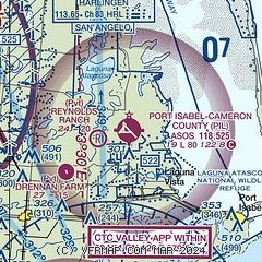
| Sectional chart |
|---|
|
| Airport distance calculator |
|---|
|
|
| Sunrise and sunset |
|---|
|
Times for 30-Jul-2026
| | Local
(UTC-5) | | Zulu
(UTC) |
|---|
| Morning civil twilight | | 06:30 | | 11:30 |
| Sunrise | | 06:55 | | 11:55 |
| Sunset | | 20:17 | | 01:17 |
| Evening civil twilight | | 20:41 | | 01:41 |
|
| Current date and time |
|---|
| Zulu (UTC) | 31-Jul-2026 04:55:31 |
|---|
| Local (UTC-5) | 30-Jul-2026 23:55:31 |
|---|
|
| METAR |
|---|
| KPIL | 310353Z AUTO 15009KT 10SM CLR 28/25 A2997 RMK AO2 SLP147 T02830250
|
KBRO
17nm S | 310353Z 15008KT 10SM CLR 29/25 A2996 RMK AO2 SLP144 T02890250
|
KHRL
17nm W | 310352Z 15010KT 10SM CLR 28/24 A2995 RMK AO2 SLP142 T02780244
|
|
| TAF |
|---|
KBRO
17nm S | 301720Z 3018/3118 16018G23KT P6SM FEW040 FM310200 14009KT P6SM SKC FM311600 15012G20KT P6SM FEW250
|
KHRL
17nm W | 301720Z 3018/3118 17015G25KT P6SM FEW045 FM310300 15009KT P6SM SKC FM311600 15013G22KT P6SM FEW250
|
|
| NOTAMs |
|---|
NOTAMs are issued by the DoD/FAA and will open in a separate window not controlled by AirNav.
|
|

