FAA INFORMATION EFFECTIVE 27 NOVEMBER 2025
Location
| FAA Identifier: | ICT |
| Lat/Long: | 37-38-59.8290N 097-25-58.9540W
37-38.997150N 097-25.982567W
37.6499525,-97.4330428
(estimated) |
| Elevation: | 1332.6 ft. / 406.2 m (surveyed) |
| Variation: | 04E (2015) |
| From city: | 5 miles SW of WICHITA, KS |
| Time zone: | UTC -6 (UTC -5 during Daylight Saving Time) |
| Zip code: | 67209 |
Airport Operations
| Airport use: | Open to the public |
| Activation date: | 04/1953 |
| Control tower: | yes |
| ARTCC: | KANSAS CITY CENTER |
| FSS: | WICHITA FLIGHT SERVICE STATION |
| NOTAMs facility: | ICT (NOTAM-D service available) |
| Attendance: | CONTINUOUS |
| Wind indicator: | lighted |
| Segmented circle: | no |
| Beacon: | white-green (lighted land airport)
Operates sunset to sunrise. |
| Fire and rescue: | ARFF index C |
| International operations: | customs landing rights airport |
Airport Communications
| UNICOM: | 122.95 |
| ATIS: | 125.15 |
| WX ASOS: | PHONE 316-800-1006 |
| WICHITA GROUND: | 121.9 348.6 |
| WICHITA TOWER: | 118.2 257.8 |
| WICHITA APPROACH: | 125.5 ;270-009 BLW 5000 FT & BYD 20 126.7 ;191-009 134.85 ;010-190 269.1 ;E IAB BLW 5000 FT 290.275 ;010-190 325.8 ;270-009 BLW 5000 FT & BYD 20 353.5 ;191-009 327.1 |
| WICHITA DEPARTURE: | 126.7 ;191-009 134.85 ;010-190 290.275 ;010-190 353.5 ;191-009 327.1 |
| CLEARANCE DELIVERY: | 125.7 |
| CLASS C: | 126.7 ;191-009 134.8 ;010-190 4000 FT & BLW 134.85 ;010-190 ABV 4000 FT 290.275 ;010-190 ABV 4000 FT 353.5 ;191-009 |
| EMERG: | 121.5 243.0 |
| IC: | 126.7 ;191-009 353.5 ;191-009 |
| RDR: | 317.425 |
| WX AWOS-3PT at BEC (11 nm E): | 119.45 (316-515-7116) |
| WX ASOS at AAO (12 nm NE): | 134.025 (316-636-2541) |
| WX AWOS-3P at 3AU (17 nm E): | 124.175 (316-733-6696) |
| WX AWOS-2 at 1K1 (17 nm NE): | 118.3 (316-530-6004) |
| WX AWOS-3P at EGT (20 nm S): | 118.875 (620-359-2156) |
- SAID IN USE. OPERATE TRANSPONDERS WITH ALTITUDE REPORTING MODE AND ADS-B (IF EQUIPPED) ENABLED ON ALL AIRPORT SURFACES.
Nearby radio navigation aids
| VOR radial/distance | | VOR name | | Freq | | Var |
|---|
| ICTr122/9.2 | | WICHITA VORTAC | | 113.80 | | 07E |
| HUTr127/31.6 | | HUTCHINSON VOR/DME | | 116.80 | | 04E |
| NDB name | | Hdg/Dist | | Freq | | Var | | ID |
|---|
| PICHE | | 010/4.4 | | 332 | | 04E | | IC | .. -.-. |
Airport Services
| Fuel available: | 100LL JET-A |
| Parking: | hangars and tiedowns |
| Airframe service: | MAJOR |
| Powerplant service: | MAJOR |
| Bottled oxygen: | HIGH/LOW |
| Bulk oxygen: | HIGH/LOW |
Runway Information
Runway 1L/19R
| Dimensions: | 10302 x 150 ft. / 3140 x 46 m |
| Surface: | concrete/grooved, in good condition |
| Weight bearing capacity: | | Single wheel: | 100.0 | | Double wheel: | 210.0 | | Double tandem: | 300.0 |
|
| Runway edge lights: | high intensity |
| RUNWAY 1L | | RUNWAY 19R |
| Latitude: | 37-38.101075N | | 37-39.696105N |
| Longitude: | 097-26.759843W | | 097-26.029860W |
| Elevation: | 1312.5 ft. | | 1329.6 ft. |
| Traffic pattern: | left | | right |
| Runway heading: | 016 magnetic, 020 true | | 196 magnetic, 200 true |
| Declared distances: | TORA:10301 TODA:10301 ASDA:10301 LDA:10301 | | TORA:10301 TODA:10301 ASDA:10301 LDA:10301 |
| Markings: | precision, in good condition | | precision, in good condition |
| RVR equipment: | touchdown, midfield, rollout | | touchdown, midfield, rollout |
| Approach lights: | ALSF2: standard 2,400 foot high intensity approach lighting system with centerline sequenced flashers (category II or III) | | MALSR: 1,400 foot medium intensity approach lighting system with runway alignment indicator lights |
| Centerline lights: | yes | | yes |
| Touchdown point: | yes, lighted | | yes, no lights |
| Instrument approach: | ILS | | ILS |
Runway 1R/19L
| Dimensions: | 7302 x 150 ft. / 2226 x 46 m |
| Surface: | concrete/grooved, in good condition |
| Weight bearing capacity: | | Single wheel: | 125.0 | | Double wheel: | 240.0 | | Double tandem: | 400.0 |
|
| Runway edge lights: | high intensity |
| RUNWAY 1R | | RUNWAY 19L |
| Latitude: | 37-38.565735N | | 37-39.696182N |
| Longitude: | 097-25.577160W | | 097-25.059413W |
| Elevation: | 1321.0 ft. | | 1319.8 ft. |
| Traffic pattern: | right | | left |
| Runway heading: | 016 magnetic, 020 true | | 196 magnetic, 200 true |
| Declared distances: | TORA:7302 TODA:7302 ASDA:7302 LDA:7302 | | TORA:7302 TODA:7302 ASDA:7302 LDA:7302 |
| Markings: | precision, in good condition | | precision, in good condition |
| Visual slope indicator: | | | 4-light PAPI on left (3.00 degrees glide path) |
| RVR equipment: | touchdown, rollout | | touchdown, rollout |
| Approach lights: | MALSR: 1,400 foot medium intensity approach lighting system with runway alignment indicator lights | | MALSR: 1,400 foot medium intensity approach lighting system with runway alignment indicator lights |
| Runway end identifier lights: | | | no |
| Touchdown point: | yes, no lights | | yes, no lights |
| Instrument approach: | ILS/DME | | ILS/DME |
Runway 14/32
| Dimensions: | 6301 x 150 ft. / 1921 x 46 m |
| Surface: | concrete/grooved, in good condition |
| Weight bearing capacity: | | Single wheel: | 100.0 | | Double wheel: | 190.0 | | Double tandem: | 280.0 |
|
| Runway edge lights: | high intensity |
| RUNWAY 14 | | RUNWAY 32 |
| Latitude: | 37-39.452700N | | 37-38.553560N |
| Longitude: | 097-26.404550W | | 097-25.751668W |
| Elevation: | 1332.1 ft. | | 1321.6 ft. |
| Traffic pattern: | left | | left |
| Runway heading: | 146 magnetic, 150 true | | 326 magnetic, 330 true |
| Declared distances: | TORA:6301 TODA:6301 ASDA:6301 LDA:6301 | | TORA:6301 TODA:6301 ASDA:6301 LDA:6301 |
| Markings: | nonprecision, in good condition | | basic, in good condition |
| Visual slope indicator: | 4-light PAPI on left (3.00 degrees glide path) | | 4-light PAPI on left (3.00 degrees glide path) |
| Runway end identifier lights: | yes | | yes |
| Touchdown point: | yes, no lights | | yes, no lights |
Airport Ownership and Management from official FAA records
| Ownership: | Publicly-owned |
| Owner: | WICHITA AIRPORT AUTHORITY
2173 AIR CARGO ROAD
WICHITA, KS 67209
Phone 316-946-4700 |
| Manager: | MR. JESSE ROMO, A.A.E.
2173 AIR CARGO ROAD
WICHITA, KS 67209
Phone 316-946-4700 |
Additional Remarks
| A39-01L/19R | PCR VALUE: 700/R/B/W/T |
| A39-14/32 | PCR VALUE: 734/R/C/W/T |
| A39-01R/19L | PCR VALUE: 707/R/A/W/T |
| - | TWY H CLSD TO ACFT WITH WINGSPAN MORE THAN 79. |
| - | TWY L AND L1 CLSD TO ACFT WITH WINGSPAN MORE THAN 118. |
| - | TWY P CLSD TO ACFT WITH WINGSPAN MORE THAN 79. |
| - | AIR CARGO RAMP CLSD TO ACFT WINGSPAN MORE THAN 148 FT. |
| - | ACFT PARKING BAS CONTACT 132.00 FOR PARKING INSTRUCTIONS PRIOR TO EXITING TWY L1. |
| - | FLIGHT NOTIFICATION SERVICE (ADCUS) AVBL. |
| - | AIRCRAFT ENGINE RUNS ABOVE IDLE NOT APPROVED ON AIRCRAFT PARKING RAMPS. |
| - | PPR REQUIRED FOR ACFT CARRYING CLASS 1DIVISION 1.1, 1.2 OR 1.3 EXPLOSIVES AS DEFINED BY 49 CFR 173.50 OR AS AMENDED. |
| - | MIGRATORY BIRDS ON AND IN VICINITY OF ARPT, ALL QUADS. |
| - | ATTENDED CONTINUOUSLY. |
| - | ATCT HAS LTD VIS OF TRML GATES 1 THRU 8, TWY H, AND CUSTOMS PRKG RAMP. |
| - | CALL FOR GATE PUSHBACK NOT REQUIRED. |
| - | TWYS F, G, H, J, P AND ALL ACFT PARKING RAMPS ARE NONMOVEMENT AREAS. |
Instrument Procedures
NOTE: All procedures below are presented as PDF files. If you need a reader for these files, you should download the free Adobe Reader.NOT FOR NAVIGATION. Please procure official charts for flight.
FAA instrument procedures published for use from 27 November 2025 at 0901Z to 25 December 2025 at 0900Z.
IAPs - Instrument Approach Procedures |
|---|
| ILS OR LOC RWY 01L | |
download (217KB) |
| ILS OR LOC RWY 01R | |
download (238KB) |
| ILS OR LOC RWY 19L | |
download (282KB) |
| ILS OR LOC RWY 19R | |
download (272KB) |
| ILS RWY 01L (SA CAT I) | |
download (190KB) |
| ILS RWY 01L (CAT II) | |
download (178KB) |
| RNAV (RNP) Z RWY 01L | |
download (217KB) |
| RNAV (RNP) Z RWY 14 | |
download (221KB) |
| RNAV (RNP) Z RWY 19L | |
download (247KB) |
| RNAV (RNP) Z RWY 19R | |
download (219KB) |
| RNAV (GPS) RWY 01R | |
download (264KB) |
| RNAV (GPS) RWY 32 | |
download (227KB) |
| RNAV (GPS) Y RWY 01L | |
download (261KB) |
| RNAV (GPS) Y RWY 14 | |
download (236KB) |
| RNAV (GPS) Y RWY 19L | |
download (258KB) |
| RNAV (GPS) Y RWY 19R | |
download (248KB) |
| VOR RWY 14 | |
download (202KB) |
| NDB RWY 01R | |
download (180KB) |
| NOTE: Special Alternate Minimums apply | |
download (146KB) |
| NOTE: Special Take-Off Minimums/Departure Procedures apply | |
download (370KB) |
Other nearby airports with instrument procedures:
KIAB - Mc Connell Air Force Base (8 nm E)
KCEA - Cessna Aircraft Field Airport (9 nm E)
KBEC - Beech Factory Airport (11 nm E)
KAAO - Colonel James Jabara Airport (12 nm NE)
K50 - Cook Airfield (13 nm E)
3AU - Augusta Municipal Airport (17 nm E)
1K1 - Lloyd Stearman Field Airport (17 nm NE)
KEGT - Wellington Municipal Airport (20 nm S)
|
|

Road maps at:
MapQuest
Bing
Google
| Aerial photo |
|---|
WARNING: Photo may not be current or correct
 Photo by David Newcomer
Photo taken 09-Oct-2015
looking north from 4,000 altitude.
Photo by David Newcomer
Photo taken 09-Oct-2015
looking north from 4,000 altitude.
Do you have a better or more recent aerial photo of Wichita Dwight D Eisenhower National Airport that you would like to share? If so, please send us your photo.
|
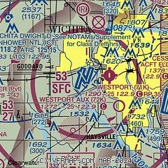
| Sectional chart |
|---|
|
CAUTION: Diagram may not be current
 Download PDF
of official airport diagram from the FAA
| Airport distance calculator |
|---|
|
|
| Sunrise and sunset |
|---|
|
Times for 29-Nov-2025
| | Local
(UTC-6) | | Zulu
(UTC) |
|---|
| Morning civil twilight | | 06:56 | | 12:56 |
| Sunrise | | 07:25 | | 13:25 |
| Sunset | | 17:11 | | 23:11 |
| Evening civil twilight | | 17:40 | | 23:40 |
|
| Current date and time |
|---|
| Zulu (UTC) | 29-Nov-2025 06:24:42 |
|---|
| Local (UTC-6) | 29-Nov-2025 00:24:42 |
|---|
|
| METAR |
|---|
| KICT | 290553Z 17019G30KT 10SM OVC025 08/04 A2990 RMK AO2 PK WND 17034/0457 SLP130 T00830044 10100 20083 401060000 56013 $
|
KIAB
8nm E | 290555Z AUTO 18019G27KT 10SM FEW007 OVC018 09/05 A2990 RMK AO2 PK WND 20030/23 SLP131 T00880048 10110 20088 401100003 55013 $
|
KBEC
11nm E | 290555Z AUTO 17017G26KT 10SM OVC019 08/04 A2992 RMK AO2 T00760042 10098 20075 400981005
|
KAAO
12nm NE | 290554Z AUTO 17018G28KT 10SM -RA OVC021 08/05 A2992 RMK AO2 PK WND 15030/0529 RAB47 SLP136 P0000 60000 T00780050 10100 20078 401001011 56013
|
K3AU
17nm E | 290555Z AUTO 17021G25KT 10SM OVC019 07/03 A2993 RMK AO2
|
KEGT
20nm S | 290555Z AUTO 10SM OVC019 08/05 A2992 RMK AO2 T00830051 10105 20083
|
|
| TAF |
|---|
| KICT | 290520Z 2906/3006 16015G25KT P6SM OVC035 WS012/21050KT FM290700 17015G25KT P6SM OVC025 WS012/21050KT FM291100 21015KT P6SM -SHRA OVC005 FM291500 32020G35KT P6SM -SHRA BKN011 FM291700 32025G40KT P6SM BKN015 FM292000 32025G35KT P6SM SCT025
|
|
| NOTAMs |
|---|
NOTAMs are issued by the DoD/FAA and will open in a separate window not controlled by AirNav.
|
|


