FAA INFORMATION EFFECTIVE 14 MAY 2026
Location
| FAA Identifier: | ISM |
| Lat/Long: | 28-17-23.3050N 081-26-13.4930W
28-17.388417N 081-26.224883W
28.2898069,-81.4370814
(estimated) |
| Elevation: | 82.1 ft. / 25.0 m (surveyed) |
| Variation: | 05W (2000) |
| From city: | 16 miles SW of ORLANDO, FL |
| Time zone: | UTC -4 (UTC -5 during Standard Time) |
| Zip code: | 34741 |
Airport Operations
| Airport use: | Open to the public |
| Activation date: | 04/1940 |
| Control tower: | yes |
| ARTCC: | JACKSONVILLE CENTER |
| FSS: | SAINT PETERSBURG FLIGHT SERVICE STATION |
| NOTAMs facility: | ISM (NOTAM-D service available) |
| Attendance: | 0700-2200 |
| Wind indicator: | lighted |
| Segmented circle: | yes |
| Lights: | WHEN ATCT CLSD ACTVT MALSF RWY 15; REIL RWY 06 & 24 & 33; PAPI RWY 06, 15, 24, & 33; MIRL RWY 06/24 & 15/33 - CTAF. |
| Beacon: | white-green (lighted land airport)
Operates sunset to sunrise. |
| Landing fee: | yes |
Airport Communications
| CTAF: | 124.45 |
| UNICOM: | 122.95 |
| ATIS: | 128.775 |
| WX AWOS-3PT: | PHONE 407-847-0533 |
| KISSIMMEE GROUND: | 121.7 [0700-2200] |
| KISSIMMEE TOWER: | 124.45 [0700-2200] |
| ORLANDO APPROACH: | 119.4 |
| ORLANDO DEPARTURE: | 119.4 |
| CLEARANCE DELIVERY: | 123.95 ;WHEN TWR CLSD 121.7 |
| ALYNA STAR: | 124.8 |
| BITHO STAR: | 128.375 |
| JAFAR STAR: | 134.05 |
| JOKRS STAR: | 134.05 |
| LEESE STAR: | 128.675 134.05 |
| MINEE STAR: | 134.05 |
| MUNGI STAR: | 128.375 |
| PRICY STAR: | 134.05 |
| SHREK STAR: | 128.675 134.05 |
| SNFLD STAR: | 128.375 |
| WX ASOS at MCO (11 nm NE): | PHONE 407-270-2241 |
| WX ASOS at ORL (16 nm N): | 127.25 (407-658-6753) |
Nearby radio navigation aids
| VOR radial/distance | | VOR name | | Freq | | Var |
|---|
| ORLr200/16.1 | | ORLANDO VORTAC | | 112.20 | | 00E |
| LALr058/35.5 | | LAKELAND VORTAC | | 116.00 | | 01E |
Airport Services
| Fuel available: | 100LL JET-A |
| Parking: | hangars and tiedowns |
| Airframe service: | MAJOR |
| Powerplant service: | MAJOR |
| Bottled oxygen: | NONE |
| Bulk oxygen: | HIGH |
Runway Information
Runway 15/33
| Dimensions: | 6001 x 100 ft. / 1829 x 30 m |
| Surface: | asphalt/grooved, in fair condition |
| Weight bearing capacity: | | PCN 45 /F/A/X/T | | Single wheel: | 114.0 | | Double wheel: | 189.0 | | Double tandem: | 300.0 |
|
| Runway edge lights: | medium intensity |
| RUNWAY 15 | | RUNWAY 33 |
| Latitude: | 28-17.774897N | | 28-16.934372N |
| Longitude: | 081-26.501888W | | 081-25.910390W |
| Elevation: | 79.8 ft. | | 76.6 ft. |
| Traffic pattern: | right | | left |
| Runway heading: | 153 magnetic, 148 true | | 333 magnetic, 328 true |
| Markings: | precision, in fair condition | | nonprecision, in fair condition |
| Visual slope indicator: | 4-light PAPI on left (3.00 degrees glide path) | | 4-light PAPI on left (3.00 degrees glide path) |
| Approach lights: | MALSF: 1,400 foot medium intensity approach lighting system with sequenced flashers | | |
| Runway end identifier lights: | | | yes |
| Touchdown point: | yes, no lights | | yes, no lights |
| Instrument approach: | ILS/DME | | |
| Obstructions: | 25 ft. tree, 1332 ft. from runway, 260 ft. left of centerline, 45:1 slope to clear | | 6 ft. fence, 200 ft. from runway, 245 ft. right of centerline
+6 FT FENCE 190 FT FM RWY END 245 FT R OF CNTRLN. |
Runway 6/24
| Dimensions: | 5001 x 100 ft. / 1524 x 30 m |
| Surface: | asphalt/grooved, in good condition |
| Weight bearing capacity: | | PCN 33 /F/A/X/T | | Single wheel: | 89.0 | | Double wheel: | 140.0 |
|
| Runway edge lights: | medium intensity |
| RUNWAY 6 | | RUNWAY 24 |
| Latitude: | 28-17.210665N | | 28-17.647212N |
| Longitude: | 081-26.642977W | | 081-25.851828W |
| Elevation: | 80.2 ft. | | 78.1 ft. |
| Traffic pattern: | right | | left |
| Runway heading: | 063 magnetic, 058 true | | 243 magnetic, 238 true |
| Markings: | nonprecision, in good condition | | nonprecision, in good condition |
| Visual slope indicator: | 4-light PAPI on left (3.00 degrees glide path) | | 4-light PAPI on left (3.00 degrees glide path) |
| Runway end identifier lights: | yes | | yes |
| Touchdown point: | yes, no lights | | yes, no lights |
| Obstructions: | 33 ft. trees, 1170 ft. from runway, 280 ft. both sides of centerline, 29:1 slope to clear | | 41 ft. pole, 1585 ft. from runway, 175 ft. right of centerline, 34:1 slope to clear |
Airport Ownership and Management from official FAA records
| Ownership: | Publicly-owned |
| Owner: | CITY OF KISSIMMEE
101 CHURCH STREET
KISSIMMEE, FL 34741-5054
Phone 407-847-2821 |
| Manager: | SHAUN GERMOLUS
KISSIMMEE GATEWAY AIRPORT, 401 DYER BOULEVARD
KISSIMMEE, FL 34741-4613
Phone 407-518-2516 |
Additional Remarks
| A30A-33 | MULT UNLGT OBSTNS FIRST 3000 FT; 250-500 FT E & W OF CNTRLN. |
| A30A-06 | HOLDING BAY RSTRD TO ACFT WITH WINGSPAN OF 49 FT OR LESS. |
| A30A-15 | CALM WIND RWY. |
| - | NOISE SENSITIVE AREA 1/2 MI N OF AER 24. DEP RWY 06 EARLY TURNOUTS NA. |
| - | LNDG FEE: CTC ARPT OR CK ARPT WEBSITE FOR DTLS, EXEMPTIONS. |
| - | REQ ALL JETS/TURBO PROPS USE NBAA CLOSE-IN PROC. |
| - | ULTRALGT ACFT NA EXCEPT PPR - AMGR. |
| - | LOW LVL VFR HEL, WILDLIFE & BIRDS ON & INVOF ARPT. |
| - | HEL RUN ON LNDG NA. |
| - | RWY 15 HAS UNLGTED OBSTNS PRESENT IN THE APCH DUE TO 52 FT TREES 1960 FT BFR AER. |
Instrument Procedures
NOTE: All procedures below are presented as PDF files. If you need a reader for these files, you should download the free Adobe Reader.NOT FOR NAVIGATION. Please procure official charts for flight.
FAA instrument procedures published for use from 14 May 2026 at 0901Z to 11 June 2026 at 0900Z.
STARs - Standard Terminal Arrivals |
|---|
| ALYNA FOUR (RNAV) | |
download (276KB) |
| BITHO SEVEN | |
download (216KB) |
| JAFAR THREE (RNAV) | |
2 pages:
[1] [2] (348KB) |
| JOKRS FOUR (RNAV) | |
2 pages:
[1] [2] (333KB) |
| LEESE THREE | |
2 pages:
[1] [2] (256KB) |
| MINEE SIX | |
2 pages:
[1] [2] (327KB) |
| MUNGI ONE (RNAV) | |
2 pages:
[1] [2] (503KB) |
| PRICY FIVE (RNAV) | |
2 pages:
[1] [2] (404KB) |
| PRICY FIVE (RNAV), CONT.2 | |
download (152KB) |
| SHREK TWO (RNAV) | |
download (190KB) |
| SLOAO ONE (RNAV) | |
download (163KB) |
| SNFLD THREE (RNAV) | |
2 pages:
[1] [2] (308KB) |
IAPs - Instrument Approach Procedures |
|---|
| ILS OR LOC RWY 15 **CHANGED** | |
download (265KB) |
| RNAV (GPS) RWY 06 | |
download (262KB) |
| RNAV (GPS) RWY 15 **CHANGED** | |
download (252KB) |
| RNAV (GPS) RWY 33 | |
download (265KB) |
| NOTE: Special Alternate Minimums apply **CHANGED** | |
download (147KB) |
| NOTE: Special Take-Off Minimums/Departure Procedures apply | |
download (324KB) |
Other nearby airports with instrument procedures:
KMCO - Orlando International Airport (11 nm NE)
KORL - Orlando Executive Airport (16 nm N)
KGIF - Winter Haven Regional Airport (22 nm SW)
X07 - Lake Wales Municipal Airport (26 nm S)
X04 - Orlando Apopka Airport (26 nm N)
|
|

Road maps at:
MapQuest
Bing
Google
| Aerial photo |
|---|
WARNING: Photo may not be current or correct
 Photo by Michael Kinghorn
Photo taken 22-Oct-2009
Photo by Michael Kinghorn
Photo taken 22-Oct-2009
Do you have a better or more recent aerial photo of Kissimmee Gateway Airport that you would like to share? If so, please send us your photo.
|
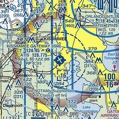
| Sectional chart |
|---|
|
CAUTION: Diagram may not be current
 Download PDF
of official airport diagram from the FAA
| Airport distance calculator |
|---|
|
|
| Sunrise and sunset |
|---|
|
Times for 09-Jun-2026
| | Local
(UTC-4) | | Zulu
(UTC) |
|---|
| Morning civil twilight | | 06:02 | | 10:02 |
| Sunrise | | 06:29 | | 10:29 |
| Sunset | | 20:21 | | 00:21 |
| Evening civil twilight | | 20:48 | | 00:48 |
|
| Current date and time |
|---|
| Zulu (UTC) | 09-Jun-2026 13:03:45 |
|---|
| Local (UTC-4) | 09-Jun-2026 09:03:45 |
|---|
|
| METAR |
|---|
| KISM | 091256Z 02003KT 10SM CLR 26/22 A3016 RMK AO2 SLP213 T02610222 PNO $
|
KMCO
9nm NE | 091253Z 03005KT 10SM FEW025 SCT150 BKN190 OVC250 26/22 A3014 RMK AO2 SLP206 T02610222
|
KORL
17nm N | 091253Z 04004KT 10SM CLR 26/22 A3015 RMK AO2 SLP211 T02560222
|
|
| TAF |
|---|
| KISM | 091125Z 0912/1012 VRB05KT P6SM BKN250 FM091400 09007KT P6SM FEW025 FEW050 BKN250 FM091900 10011KT P6SM VCSH BKN045 BKN250 FM100200 09006KT P6SM SCT070 BKN250
|
KMCO
9nm NE | 091125Z 0912/1018 VRB05KT P6SM FEW025 OVC220 FM091500 08006KT P6SM FEW025 FEW050 BKN250 FM091900 09011KT P6SM VCSH BKN045 BKN250 FM100100 09006KT P6SM SCT070 BKN250 FM101500 12007KT P6SM FEW025 SCT040 BKN250
|
|
| NOTAMs |
|---|
NOTAMs are issued by the DoD/FAA and will open in a separate window not controlled by AirNav.
|
|


