FAA INFORMATION EFFECTIVE 14 MAY 2026
Location
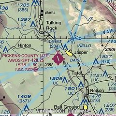
| FAA Identifier: | JZP |
| Lat/Long: | 34-27-12.5000N 084-27-26.0000W
34-27.208333N 084-27.433333W
34.4534722,-84.4572222
(estimated) |
| Elevation: | 1535.1 ft. / 467.9 m (surveyed) |
| Variation: | 04W (2000) |
| From city: | 2 miles SW of JASPER, GA |
| Time zone: | UTC -4 (UTC -5 during Standard Time) |
| Zip code: | 30143 |
Airport Operations
| Airport use: | Open to the public |
| Activation date: | 08/1975 |
| Control tower: | no |
| ARTCC: | ATLANTA CENTER |
| FSS: | MACON FLIGHT SERVICE STATION |
| NOTAMs facility: | MCN (NOTAM-D service available) |
| Attendance: | 0900-1800 |
| Wind indicator: | lighted |
| Segmented circle: | yes |
| Lights: | REIL RWY 16 & 34; PAPI RWY 16 & 34; MIRL RWY 16/34 - OPR CONSLY. |
| Beacon: | white-green (lighted land airport)
Operates sunset to sunrise. |
Airport Communications
| CTAF/UNICOM: | 122.725 |
| WX AWOS-AV: | 120.025 (706-253-9008) |
| WX AWOS-3PT at CNI (9 nm S): | 119.825 (678-454-2065) |
| WX AWOS-3 at 49A (11 nm N): | 118.075 (706 276-4513) |
- APCH/DEP SVC PRVDD BY ATLANTA ARTCC (MOUNT OGLETHORPE RCAG) ON FREQS 133.1/342.425
Nearby radio navigation aids
| VOR radial/distance | | VOR name | | Freq | | Var |
|---|
| RMGr061/37.2 | | ROME VORTAC | | 115.40 | | 01E |
Airport Services
| Fuel available: | 100LL JET-A+ |
| Parking: | tiedowns |
| Airframe service: | MAJOR |
| Powerplant service: | MINOR |
| Bottled oxygen: | NONE |
| Bulk oxygen: | NONE |
Runway Information
Runway 16/34
| Dimensions: | 5000 x 100 ft. / 1524 x 30 m |
| Surface: | asphalt, in fair condition |
| Weight bearing capacity: | | Single wheel: | 60.5 | | Double wheel: | 95.0 |
|
| Runway edge lights: | medium intensity |
| RUNWAY 16 | | RUNWAY 34 |
| Latitude: | 34-27.592868N | | 34-26.825088N |
| Longitude: | 084-27.613457W | | 084-27.251385W |
| Elevation: | 1500.5 ft. | | 1535.1 ft. |
| Traffic pattern: | left | | left |
| Runway heading: | 163 magnetic, 159 true | | 343 magnetic, 339 true |
| Markings: | nonprecision, in good condition | | nonprecision, in good condition |
| Visual slope indicator: | 2-light PAPI on right (3.00 degrees glide path)
PAPI UNUSBL BYD 4 DEG LEFT OF CNTRLN. | | 2-light PAPI on left (3.00 degrees glide path) |
| Runway end identifier lights: | yes | | yes |
| Touchdown point: | yes, no lights | | yes, no lights |
| Obstructions: | 37 ft. trees, 980 ft. from runway, 365 ft. right of centerline, 21:1 slope to clear | | 23 ft. trees, 527 ft. from runway, 139 ft. left of centerline, 14:1 slope to clear |
Airport Ownership and Management from official FAA records
| Ownership: | Publicly-owned |
| Owner: | PICKENS COUNTY
1266 EAST CHURCH STREET, SUITE 201
JASPER, GA 30143
Phone 706-253-8817 |
| Manager: | STACY MCCLURE
193 AIRPORT ROAD
JASPER, GA 30143
Phone 706-253-8967 |
Additional Remarks
| - | DEER & WILDLIFE ON & INVOF ARPT. |
| - | FOR CD CTC ATLANTA ARTCC AT 770-210-7692. |
Instrument Procedures
NOTE: All procedures below are presented as PDF files. If you need a reader for these files, you should download the free Adobe Reader.NOT FOR NAVIGATION. Please procure official charts for flight.
FAA instrument procedures published for use from 14 May 2026 at 0901Z to 11 June 2026 at 0900Z.
IAPs - Instrument Approach Procedures |
|---|
| RNAV (GPS) RWY 16 **CHANGED** | |
download (201KB) |
| RNAV (GPS) RWY 34 **CHANGED** | |
download (211KB) |
| NOTE: Special Alternate Minimums apply | |
download (158KB) |
| NOTE: Special Take-Off Minimums/Departure Procedures apply | |
download (189KB) |
Other nearby airports with instrument procedures:
KCNI - Cherokee County Regional Airport (9 nm S)
49A - Gilmer County Airport (11 nm N)
KCZL - Tom B David Field Airport (24 nm W)
KDNN - Dalton Municipal Airport (26 nm NW)
KRYY - Cobb County International Airport-McCollum Field (27 nm S)
|
|

Road maps at:
MapQuest
Bing
Google
| Aerial photo |
|---|
WARNING: Photo may not be current or correct
 Photo by Russell Ziprik
Photo taken 21-Nov-2014
looking north.
Photo by Russell Ziprik
Photo taken 21-Nov-2014
looking north.
Do you have a better or more recent aerial photo of Pickens County Airport that you would like to share? If so, please send us your photo.
|
| Sectional chart |
|---|
|
| Airport distance calculator |
|---|
|
|
| Sunrise and sunset |
|---|
|
Times for 09-Jun-2026
| | Local
(UTC-4) | | Zulu
(UTC) |
|---|
| Morning civil twilight | | 05:57 | | 09:57 |
| Sunrise | | 06:26 | | 10:26 |
| Sunset | | 20:48 | | 00:48 |
| Evening civil twilight | | 21:17 | | 01:17 |
|
| Current date and time |
|---|
| Zulu (UTC) | 09-Jun-2026 09:04:54 |
|---|
| Local (UTC-4) | 09-Jun-2026 05:04:54 |
|---|
|
| METAR |
|---|
KCNI
9nm S | 090855Z AUTO 11003KT 3/4SM FG OVC001 21/ A3021 RMK AO2 T0215////
|
K49A
11nm N | 090855Z AUTO 00000KT 4SM BR OVC090 21/21 A3020 RMK AO2
|
|
| TAF |
|---|
KRYY
27nm S | 090530Z 0906/1006 00000KT 5SM -DZ BR SCT004 BKN015 OVC080 TEMPO 0907/0910 3SM BR BKN004 FM091000 00000KT 3SM BR BKN004 BKN012 OVC040 FM091500 20003KT 6SM -SHRA SCT012 BKN020 OVC040 FM091800 19004KT 4SM -SHRA BR SCT015 BKN025 PROB30 0919/0924 -TSRA BKN025CB FM100100 00000KT P6SM SCT025 BKN120
|
KMGE
32nm S | 082115Z 0821/1003 22005KT 9000 -SHRA VCTS FEW004 BKN006 BKN025CB OVC080 QNH3010INS TEMPO 0821/0822 VRB12G25KT 4800 TSRAGR BR BKN007 OVC020CB BECMG 0821/0822 24005KT 9999 VCTS SCT006 BKN025CB OVC080 QNH3012INS TEMPO 0822/0823 VRB15G25KT 4800 TSRAGR BR BKN007 OVC020CB BECMG 0822/0823 25005KT 9999 VCSH BKN035 OVC120 QNH3014INS BECMG 0908/0909 VRB05KT 4800 BR BKN007 OVC015 QNH3015INS BECMG 0914/0915 15007KT 9999 NSW SCT015 BKN050 OVC100 QNH3016INS BECMG 0915/0916 16009KT 8000 -SHRA VCTS BKN025CB OVC
|
|
| NOTAMs |
|---|
NOTAMs are issued by the DoD/FAA and will open in a separate window not controlled by AirNav.
|
|


