FAA INFORMATION EFFECTIVE 16 APRIL 2026
Location
| FAA Identifier: | K38 |
| Lat/Long: | 39-44-06.6000N 097-02-51.3000W
39-44.110000N 097-02.855000W
39.7351667,-97.0475833
(estimated) |
| Elevation: | 1436.5 ft. / 437.8 m (surveyed) |
| Variation: | 06E (1990) |
| From city: | 5 miles S of WASHINGTON, KS |
| Time zone: | UTC -5 (UTC -6 during Standard Time) |
| Zip code: | 66953 |
Airport Operations
| Airport use: | Open to the public |
| Activation date: | 01/1980 |
| Control tower: | no |
| ARTCC: | KANSAS CITY CENTER |
| FSS: | WICHITA FLIGHT SERVICE STATION |
| NOTAMs facility: | ICT (NOTAM-D service available) |
| Attendance: | UNATNDD |
| Wind indicator: | yes |
| Segmented circle: | no |
| Lights: | ACTVT MIRL RWY 17/35 - CTAF. |
| Beacon: | white-green (lighted land airport)
Operates sunset to sunrise. |
Airport Communications
- APCH/DEP CTL SVC PRVDD BY KANSAS CITY ARTCC (ZKC) ON FREQS 127.35/257.975 (MANHATTAN RCAG).
Nearby radio navigation aids
| VOR radial/distance | | VOR name | | Freq | | Var |
|---|
| BIEr195/(36.5) | | BEATRICE VOR | | 110.60 | | 07E |
| MHKr330/39.5 | | MANHATTAN VOR/DME | | 110.20 | | 04E |
| NDB name | | Hdg/Dist | | Freq | | Var | | ID |
|---|
| FAIRBURY | | 162/27.0 | | 293 | | 06E | | FBY | ..-. -... -.-- |
Airport Services
Runway Information
Runway 17/35
| Dimensions: | 3406 x 60 ft. / 1038 x 18 m |
| Surface: | concrete, in good condition |
| Runway edge lights: | medium intensity |
| Runway edge markings: | EXTENSIVE PAVEMENT CRACKING & LOOSE STONES. |
| RUNWAY 17 | | RUNWAY 35 |
| Latitude: | 39-44.390798N | | 39-43.829835N |
| Longitude: | 097-02.853932W | | 097-02.856890W |
| Elevation: | 1436.5 ft. | | 1425.9 ft. |
| Traffic pattern: | left | | left |
| Runway heading: | 174 magnetic, 180 true | | 354 magnetic, 000 true |
| Displaced threshold: | 220 ft. | | no |
| Markings: | nonprecision, in poor condition | | nonprecision, in good condition |
| Touchdown point: | yes, no lights | | yes, no lights |
| Obstructions: | 15 ft. road, 290 ft. from runway, 300 ft. left and right of centerline, 6:1 slope to clear
OBSTN CLNC SLP 34:1 TO THE DTHR. | | 68 ft. pline, marked, 1562 ft. from runway, 20:1 slope to clear |
Airport Ownership and Management from official FAA records
| Ownership: | Publicly-owned |
| Owner: | WASHINGTON COUNTY
CO CMSNRS, WASH CO COURTHOUSE, 214 C ST #2
WASHINGTON, KS 66968-1928
Phone 785-325-2974
ALSO WASHINGTON CO PUBLIC WORKS- WCPW@BLUEVALLEY.NET 785-541-0533. |
| Manager: | JIMMY WORKMAN
303 C ST.
WASHINGTON, KS 66968
Phone 785-541-0533
PUBLIC WORKS DIRECTOR. ASST MGR BRAD FORTENIER, 785-747-6640, BRAD@BRADFORDBUILT.NET |
Additional Remarks
| - | 24 HR PHONE AVBL FOR PUBLIC USE WITH PHONE CARD. |
| - | FOR CD CTC KANSAS CITY ARTCC AT 913-254-8508. |
Instrument Procedures
NOTE: All procedures below are presented as PDF files. If you need a reader for these files, you should download the free Adobe Reader.NOT FOR NAVIGATION. Please procure official charts for flight.
FAA instrument procedures published for use from 16 April 2026 at 0901Z to 14 May 2026 at 0900Z.
IAPs - Instrument Approach Procedures |
|---|
| RNAV (GPS) RWY 17 | |
download (187KB) |
| RNAV (GPS) RWY 35 | |
download (206KB) |
| NOTE: Special Take-Off Minimums/Departure Procedures apply | |
download (360KB) |
Other nearby airports with instrument procedures:
KMYZ - Marysville Municipal Airport (21 nm E)
KCYW - Clay Center Municipal Airport (21 nm S)
KFBY - Fairbury Municipal Airport (27 nm N)
KRPB - Belleville Municipal Airport (29 nm W)
KCNK - Blosser Municipal Airport (30 nm W)
|
|

Road maps at:
MapQuest
Bing
Google
| Aerial photo |
|---|
WARNING: Photo may not be current or correct

Do you have a better or more recent aerial photo of Washington County Veteran's Memorial Airport that you would like to share? If so, please send us your photo.
|
| Sectional chart |
|---|
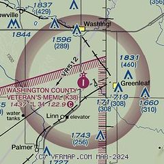
|
| Airport distance calculator |
|---|
|
|
| Sunrise and sunset |
|---|
|
Times for 09-May-2026
| | Local
(UTC-5) | | Zulu
(UTC) |
|---|
| Morning civil twilight | | 05:51 | | 10:51 |
| Sunrise | | 06:20 | | 11:20 |
| Sunset | | 20:29 | | 01:29 |
| Evening civil twilight | | 20:59 | | 01:59 |
|
| Current date and time |
|---|
| Zulu (UTC) | 09-May-2026 09:56:26 |
|---|
| Local (UTC-5) | 09-May-2026 04:56:26 |
|---|
|
| METAR |
|---|
KMYZ
21nm E | 090935Z AUTO 00000KT 10SM CLR 06/05 A2979 RMK AO2
|
KCNK
30nm W | 090855Z AUTO 26006KT 10SM CLR 12/03 A2980 RMK AO2 SLP082 T01220028 50001
|
KHJH
35nm NW | 090935Z AUTO 00000KT 10SM CLR 05/01 A2980 RMK AO2 T00540011
|
KBIE
36nm N | 090935Z AUTO 00000KT 10SM CLR 08/04 A2978 RMK AO2 T00780043
|
KMHK
40nm SE | 090852Z AUTO 25003KT 10SM CLR 07/07 A2980 RMK AO2 SLP089 T00670067 55001
|
|
| TAF |
|---|
KMHK
40nm SE | 090520Z 0906/1006 23006KT P6SM SKC FM091500 24010KT P6SM FEW150 FM091700 25014G25KT P6SM BKN120 FM092000 30007KT P6SM VCSH BKN120
|
KFRI
44nm S | 082000Z 0820/1002 VRB06KT -DZ 9999 BKN100 QNH2978INS BECMG 0822/0823 24009KT 9999 FEW150 QNH2979INS BECMG 0920/0921 20010G20KT 9999 SCT080 QNH2973INS BECMG 0923/0924 18015G25KT 4800 -TSRA BKN040CB QNH2975INS TX29/0920Z TN08/0911Z LAST NO AMDS AFT 0821 NEXT 1112
|
|
| NOTAMs |
|---|
NOTAMs are issued by the DoD/FAA and will open in a separate window not controlled by AirNav.
|
|

