FAA INFORMATION EFFECTIVE 14 MAY 2026
Location
| FAA Identifier: | ARV |
| Lat/Long: | 45-55-40.5000N 089-43-51.4000W
45-55.675000N 089-43.856667W
45.9279167,-89.7309444
(estimated) |
| Elevation: | 1629.5 ft. / 496.7 m (surveyed) |
| Variation: | 02W (2010) |
| From city: | 3 miles NW of MINOCQUA-WOODRUFF, WI |
| Time zone: | UTC -5 (UTC -6 during Standard Time) |
| Zip code: | 54568 |
Airport Operations
| Airport use: | Open to the public |
| Activation date: | 12/1945 |
| Control tower: | no |
| ARTCC: | MINNEAPOLIS CENTER |
| FSS: | GREEN BAY FLIGHT SERVICE STATION |
| NOTAMs facility: | ARV (NOTAM-D service available) |
| Attendance: | OCT-MAY 0800-1700, JUN-SEP 0800-1800
FOR ATTENDANT OTHER HRS CALL 715-490-4418. |
| Wind indicator: | lighted |
| Segmented circle: | no |
| Lights: | HIRL RWY 18/36 PRESET TO LOW SS-SR; INCR INTST AND ACTVT MALSR RWY 36; REIL RWY 18 & 28; VASI RWY 18 & 36; PAPI RWY 28; MIRL RWY 10/28 - CTAF. |
| Beacon: | white-green (lighted land airport)
Operates sunset to sunrise. |
Airport Communications
| CTAF/UNICOM: | 122.7 |
| WX AWOS-3PT: | 121.125 (715-356-2417) |
| WX AWOS-3PT at D25 (13 nm NW): | 118.175 (715-543-2004) |
| WX AWOS-3 at EGV (19 nm E): | 118.325 (715-479-1465) |
- APCH/DEP SVC PRVDD BY MINNEAPOLIS ARTCC ON FREQS 133.65/281.5 (RHINELANDER RCAG).
Nearby radio navigation aids
| VOR radial/distance | | VOR name | | Freq | | Var |
|---|
| RHIr325/21.0 | | RHINELANDER VOR/DME | | 115.05 | | 02E |
| IWDr155/39.8 | | IRONWOOD VOR/DME | | 108.80 | | 01E |
Airport Services
| Fuel available: | 100LL JET-A1+ |
| Parking: | hangars and tiedowns |
| Airframe service: | MINOR |
| Powerplant service: | MINOR |
| Bottled oxygen: | NONE |
Runway Information
Runway 18/36
| Dimensions: | 5150 x 100 ft. / 1570 x 30 m |
| Surface: | asphalt, in good condition |
| Weight bearing capacity: | | Single wheel: | 90.0 | | Double wheel: | 150.0 |
|
| Runway edge lights: | high intensity
NSTD HIRL; NSTD THLD LGTS MALS TYPE THLD LGT BAR IN ADDITION TO STD LGTG. |
| RUNWAY 18 | | RUNWAY 36 |
| Latitude: | 45-56.263492N | | 45-55.416375N |
| Longitude: | 089-43.981747W | | 089-43.958900W |
| Elevation: | 1629.5 ft. | | 1623.6 ft. |
| Traffic pattern: | left | | left |
| Runway heading: | 181 magnetic, 179 true | | 001 magnetic, 359 true |
| Markings: | nonprecision, in fair condition | | nonprecision, in fair condition |
| Visual slope indicator: | 4-box VASI on left (3.00 degrees glide path) | | 4-box VASI on left (3.00 degrees glide path) |
| Approach lights: | | | MALSR: 1,400 foot medium intensity approach lighting system with runway alignment indicator lights |
| Runway end identifier lights: | yes | | no |
| Touchdown point: | yes, no lights | | yes, no lights |
| Instrument approach: | | | LOCALIZER |
| Obstructions: | 100 ft. trees, 3150 ft. from runway, 400 ft. left of centerline, 29:1 slope to clear | | none |
Runway 10/28
| Dimensions: | 3602 x 75 ft. / 1098 x 23 m |
| Surface: | asphalt, in good condition |
| Weight bearing capacity: | |
| Runway edge lights: | medium intensity |
| RUNWAY 10 | | RUNWAY 28 |
| Latitude: | 45-55.494718N | | 45-55.386360N |
| Longitude: | 089-44.111742W | | 089-43.276800W |
| Elevation: | 1622.5 ft. | | 1622.8 ft. |
| Traffic pattern: | left | | left |
| Runway heading: | 103 magnetic, 101 true | | 283 magnetic, 281 true |
| Markings: | nonprecision, in good condition | | nonprecision, in good condition |
| Visual slope indicator: | | | 2-light PAPI on left (3.00 degrees glide path) |
| Runway end identifier lights: | no | | yes |
| Touchdown point: | yes, no lights | | yes, no lights |
| Obstructions: | 71 ft. trees, 1000 ft. from runway, 190 ft. right of centerline, 11:1 slope to clear | | none |
Airport Ownership and Management from official FAA records
| Ownership: | Publicly-owned |
| Owner: | LAKELAND AIRPORT COMMISSION
1545 N. FARMING RD.
WOODRUFF, WI 54568
Phone (715) 356-4340
TOWNS OF ARBOR VITAE, LAC DU FLAMBEAU, MINOCQUA, WOODRUFF. |
| Manager: | JESSE BIRGINAL
1545 N. FARMING RD
WOODRUFF, WI 54568
Phone (715) 356-3891
EMAIL ADDRESS: LAKELANDAIRPORT@FRONTIER.COM (ALL LOWER CASE) |
Additional Remarks
| - | SANDHILL CRANES ON & INVOF ARPT. |
| - | FOR CD IF UNA TO CTC ON FSS FREQ, CTC MINNEAPOLIS ARTCC AT 651-463-5588. |
Instrument Procedures
NOTE: All procedures below are presented as PDF files. If you need a reader for these files, you should download the free Adobe Reader.NOT FOR NAVIGATION. Please procure official charts for flight.
FAA instrument procedures published for use from 14 May 2026 at 0901Z to 11 June 2026 at 0900Z.
IAPs - Instrument Approach Procedures |
|---|
| RNAV (GPS) RWY 18 **CHANGED** | |
download (267KB) |
| RNAV (GPS) RWY 28 **CHANGED** | |
download (229KB) |
| RNAV (GPS) RWY 36 **CHANGED** | |
download (235KB) |
| NOTE: Special Alternate Minimums apply | |
download (140KB) |
| NOTE: Special Take-Off Minimums/Departure Procedures apply | |
download (478KB) |
Other nearby airports with instrument procedures:
D25 - Manitowish Waters Airport (13 nm NW)
KEGV - Eagle River Union Airport (19 nm E)
KRHI - Rhinelander/Oneida County Airport (21 nm SE)
KLNL - Kings Land O' Lakes Airport (26 nm NE)
KTKV - Tomahawk Regional Airport (28 nm S)
|
|

Road maps at:
MapQuest
Bing
Google
| Aerial photo |
|---|
WARNING: Photo may not be current or correct
 Photo by Lee Ward, co-pilot Frank Zsohar
Photo taken 12-May-2007
Photo by Lee Ward, co-pilot Frank Zsohar
Photo taken 12-May-2007
Do you have a better or more recent aerial photo of Lakeland Airport/Noble F. Lee Memorial Field that you would like to share? If so, please send us your photo.
|
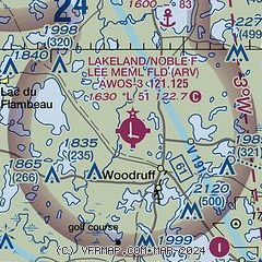
| Sectional chart |
|---|
|
| Airport distance calculator |
|---|
|
|
| Sunrise and sunset |
|---|
|
Times for 30-May-2026
| | Local
(UTC-5) | | Zulu
(UTC) |
|---|
| Morning civil twilight | | 04:37 | | 09:37 |
| Sunrise | | 05:14 | | 10:14 |
| Sunset | | 20:39 | | 01:39 |
| Evening civil twilight | | 21:16 | | 02:16 |
|
| Current date and time |
|---|
| Zulu (UTC) | 31-May-2026 00:15:56 |
|---|
| Local (UTC-5) | 30-May-2026 19:15:56 |
|---|
|
| METAR |
|---|
| KARV | 302355Z AUTO 14008G14KT 10SM CLR 23/02 A3015 RMK AO2 T02250015 10248 20225
|
KD25
13nm NW | 302355Z AUTO 15006KT 10SM CLR 22/04 A3015 RMK AO2 T02200038 10250 20219
|
KEGV
19nm E | 302355Z AUTO 13006KT 10SM CLR 21/M03 A3017 RMK AO2 T02101030 10245 20208
|
|
| TAF |
|---|
KRHI
20nm SE | 301720Z 3018/3118 12010KT P6SM SCT250 FM310300 14004KT P6SM SKC FM311300 17004KT P6SM SCT250
|
|
| NOTAMs |
|---|
NOTAMs are issued by the DoD/FAA and will open in a separate window not controlled by AirNav.
|
|

