FAA INFORMATION EFFECTIVE 16 APRIL 2026
Location
| FAA Identifier: | AWO |
| Lat/Long: | 48-09-38.7000N 122-09-32.5000W
48-09.645000N 122-09.541667W
48.1607500,-122.1590278
(estimated) |
| Elevation: | 141.8 ft. / 43.2 m (surveyed) |
| Variation: | 17E (2010) |
| From city: | 3 miles SW of ARLINGTON, WA |
| Time zone: | UTC -7 (UTC -8 during Standard Time) |
| Zip code: | 98223 |
Airport Operations
| Airport use: | Open to the public |
| Activation date: | 08/1937 |
| Control tower: | no |
| ARTCC: | SEATTLE CENTER |
| FSS: | SEATTLE FLIGHT SERVICE STATION |
| NOTAMs facility: | AWO (NOTAM-D service available) |
| Attendance: | M-F 0800-1700 |
| Pattern altitude: | 1199.8 ft. MSL
TPA FOR ULTRALGTS 542 (400), HELICOPTERS 642 (500). |
| Wind indicator: | lighted |
| Segmented circle: | yes |
| Lights: | REIL RWY 11 & 29 OPR SS-SR; PAPI RWY 11, 16, 29 & 34 OPR CONSLY. ACTVT MALS RWY 34; REILS RWY 16; RWY 16/34 EDGE LIGHTS; TWY LGTS CTAF. |
| Beacon: | white-green (lighted land airport)
Operates sunset to sunrise. |
Airport Communications
| CTAF: | 122.725 |
| WX AWOS-3PT: | 135.625 (360-435-8045) |
| SEATTLE APPROACH: | 128.5 [0530-0000] |
| SEATTLE DEPARTURE: | 128.5 [0530-0000] |
| CLEARANCE DELIVERY: | 121.725 |
| WX ASOS at PAE (16 nm S): | PHONE 425-355-6192 |
Nearby radio navigation aids
| VOR radial/distance | | VOR name | | Freq | | Var |
|---|
| PAEr358/15.2 | | PAINE VOR/DME | | 110.60 | | 20E |
| CVVr084/23.2 | | PENN COVE VOR/DME | | 117.20 | | 19E |
| NDB name | | Hdg/Dist | | Freq | | Var | | ID |
|---|
| WATON | | 341/5.1 | | 382 | | 17E | | AW | .- .-- |
Airport Services
| Fuel available: | 100LL JET-A
A:PHONE 360-435-5700 FOR AFTER HRS SVC.
100LL:100L FUEL AVBL 24 HR CREDIT CARD SVC. |
| Parking: | tiedowns |
| Airframe service: | MAJOR |
| Powerplant service: | MAJOR |
| Bottled oxygen: | NONE |
| Bulk oxygen: | NONE |
Runway Information
Runway 16/34
| Dimensions: | 5332 x 100 ft. / 1625 x 30 m |
| Surface: | asphalt, in excellent condition |
| Weight bearing capacity: | | Single wheel: | 114.0 | | Double wheel: | 150.0 | | Double tandem: | 270.0 |
|
| Runway edge lights: | medium intensity |
| Operational restrictions: | RWY 34 CALM WIND RWY. |
| RUNWAY 16 | | RUNWAY 34 |
| Latitude: | 48-10.160715N | | 48-09.283907N |
| Longitude: | 122-09.391613W | | 122-09.370955W |
| Elevation: | 140.9 ft. | | 127.5 ft. |
| Traffic pattern: | right | | left |
| Runway heading: | 162 magnetic, 179 true | | 342 magnetic, 359 true |
| Markings: | nonprecision, in good condition | | nonprecision, in good condition |
| Visual slope indicator: | 2-light PAPI on left (3.00 degrees glide path) | | 2-light PAPI on left (3.00 degrees glide path) |
| Approach lights: | | | MALS: 1,400 foot medium intensity approach lighting system |
| Runway end identifier lights: | yes | | |
| Touchdown point: | yes, no lights | | yes, no lights |
| Instrument approach: | | | LOCALIZER |
| Obstructions: | 92 ft. tree, 2287 ft. from runway, 200 ft. left of centerline, 22:1 slope to clear | | none |
Runway 11/29
| Dimensions: | 3498 x 75 ft. / 1066 x 23 m |
| Surface: | asphalt, in excellent condition |
| Weight bearing capacity: | | Single wheel: | 32.0 | | Double wheel: | 34.0 | | Double tandem: | 59.0 |
|
| RUNWAY 11 | | RUNWAY 29 |
| Latitude: | 48-09.700633N | | 48-09.352913N |
| Longitude: | 122-10.127332W | | 122-09.442320W |
| Elevation: | 132.4 ft. | | 128.2 ft. |
| Traffic pattern: | right | | left |
| Runway heading: | 110 magnetic, 127 true | | 290 magnetic, 307 true |
| Markings: | basic, in good condition | | basic, in good condition |
| Visual slope indicator: | 2-light PAPI on left (3.50 degrees glide path) | | 2-light PAPI on left (4.00 degrees glide path) |
| Runway end identifier lights: | yes | | yes |
| Touchdown point: | yes, no lights | | yes, no lights |
| Obstructions: | none | | 176 ft. tree, 3967 ft. from runway, 465 ft. right of centerline, 21:1 slope to clear |
Airport Ownership and Management from official FAA records
| Ownership: | Publicly-owned |
| Owner: | CITY OF ARLINGTON
CITY HALL, 238 N OLYMPIC
ARLINGTON, WA 98223
Phone 360-403-3470 |
| Manager: | MARTY WRAY
18204 59TH AVE NE, STE A
ARLINGTON, WA 98223
Phone 360-403-3471 |
Additional Remarks
| - | GLIDER OPERATIONS AT ARPT DAILY. |
| - | RWY 11/29 TURF LCTD BTN D2 AND D3 DIMENSIONS 1400 FT X 100 FT. |
| - | ULTRALIGHT AND POWERED PARACHUTE OPS DAILY WEST OF RWY 16/34 |
| - | WILDLIFE ON AND INVOF ARPT. ALTERNATE PHONE NUMBER FOR AIRPORT: 360-403-3470 |
| - | WINTER WEATHER OPERATIONS AND REPORTING MONDAY-FRIDAY 1600-0000Z. |
| - | FOR ADDNL DETAILS & RULES ON LOCAL PROCS CALL 360-403-3470. |
| - | FOR CD WHEN ATCT IS CLSD CTC SEATTLE APCH AT 206-214-4722. |
| - | GLIDER TURF PARALLEL EAST OF RWY 16/34, FULL LENGTH DIMENSIONS 3450 FT X 145 FT. |
Instrument Procedures
NOTE: All procedures below are presented as PDF files. If you need a reader for these files, you should download the free Adobe Reader.NOT FOR NAVIGATION. Please procure official charts for flight.
FAA instrument procedures published for use from 16 April 2026 at 0901Z to 14 May 2026 at 0900Z.
IAPs - Instrument Approach Procedures |
|---|
| RNAV (GPS) RWY 34 | |
download (306KB) |
| LOC RWY 34 | |
download (301KB) |
| NDB RWY 34 | |
download (303KB) |
| NOTE: Special Alternate Minimums apply | |
download (208KB) |
Departure Procedures |
|---|
| ARLINGTON TWO | |
download (149KB) |
| NOTE: Special Take-Off Minimums/Departure Procedures apply | |
download (223KB) |
Other nearby airports with instrument procedures:
S43 - Harvey Field Airport (16 nm S)
KPAE - Seattle Paine Field International Airport (16 nm S)
KOKH - DeLaurentis Airport (21 nm W)
KBVS - Skagit Regional Airport (21 nm NW)
KNUW - Whidbey Island Naval Air Station (Ault Field) Airport (23 nm NW)
|
|

Road maps at:
MapQuest
Bing
Google
| Aerial photo |
|---|
WARNING: Photo may not be current or correct
 Photo taken 30-Jun-2019
looking east.
Photo taken 30-Jun-2019
looking east.
Do you have a better or more recent aerial photo of Arlington Municipal Airport that you would like to share? If so, please send us your photo.
|
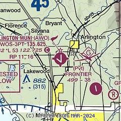
| Sectional chart |
|---|
|
CAUTION: Diagram may not be current

| Airport distance calculator |
|---|
|
|
| Sunrise and sunset |
|---|
|
Times for 13-May-2026
| | Local
(UTC-7) | | Zulu
(UTC) |
|---|
| Morning civil twilight | | 04:56 | | 11:56 |
| Sunrise | | 05:33 | | 12:33 |
| Sunset | | 20:37 | | 03:37 |
| Evening civil twilight | | 21:14 | | 04:14 |
|
| Current date and time |
|---|
| Zulu (UTC) | 13-May-2026 14:12:25 |
|---|
| Local (UTC-7) | 13-May-2026 07:12:25 |
|---|
|
| METAR |
|---|
| KAWO | 131356Z AUTO 13006KT 6SM -RA BR FEW013 OVC036 11/11 A2986 RMK AO2 SLP118 P0010 T01110111
|
KPAE
15nm S | 131353Z 17011KT 10SM FEW008 OVC085 11/09 A2986 RMK AO2 RAE31 SLP108 P0005 T01060094
|
KNRA
19nm W | 131246Z AUTO 00000KT 10SM BKN016 OVC021 12/09 A2983 RMK AO2 SLP044 T01170094 TSNO $
|
|
| TAF |
|---|
KPAE
15nm S | 131120Z 1312/1412 17008KT P6SM -SHRA SCT015 OVC070 FM131500 18010KT P6SM VCSH OVC015 FM131800 18012KT 5SM -RA BR OVC020 FM132000 30010KT 5SM -RA BR OVC015 FM140100 32008KT 4SM -SHRA BR OVC020 FM140600 18008KT P6SM VCSH OVC025
|
|
| NOTAMs |
|---|
NOTAMs are issued by the DoD/FAA and will open in a separate window not controlled by AirNav.
|
|


