FAA INFORMATION EFFECTIVE 09 JULY 2026
Location
| FAA Identifier: | BFR |
| Lat/Long: | 38-50-24.1000N 086-26-43.3000W
38-50.401667N 086-26.721667W
38.8400278,-86.4453611
(estimated) |
| Elevation: | 727.4 ft. / 221.7 m (surveyed) |
| Variation: | 04W (2010) |
| From city: | 3 miles SE of BEDFORD, IN |
| Time zone: | UTC -4 (UTC -5 during Standard Time) |
| Zip code: | 47421 |
Airport Operations
| Airport use: | Open to the public |
| Activation date: | 03/1942 |
| Control tower: | no |
| ARTCC: | INDIANAPOLIS CENTER |
| FSS: | TERRE HAUTE FLIGHT SERVICE STATION |
| NOTAMs facility: | HUF (NOTAM-D service available) |
| Attendance: | MON-FRI 0900-1700, ALL SAT 0900-1700
ARPT CLSD NEW YEARS, THANKSGIVING & CHRISTMAS DAY. |
| Pattern altitude: | 1527.4 ft. MSL |
| Wind indicator: | lighted |
| Segmented circle: | no |
| Lights: | ACTVT REIL RWY 13 & 31; MIRL RWY 06/24 & 13/31 - CTAF. MIRL RWY 06/24 & 13/31 PRESET LOW INTST; INCR INTST - CTAF. |
| Beacon: | white-green (lighted land airport)
Operates sunset to sunrise. |
Airport Communications
| CTAF/UNICOM: | 122.8 |
| WX AWOS-3PT: | 119.125 (812-275-8306) |
| LOUISVILLE APPROACH: | 123.675 |
| LOUISVILLE DEPARTURE: | 123.675 |
Nearby radio navigation aids
| VOR radial/distance | | VOR name | | Freq | | Var |
|---|
| OOMr159/19.8 | | HOOSIER VORTAC | | 110.20 | | 02W |
Airport Services
| Fuel available: | 100LL JET-A+ |
| Parking: | hangars and tiedowns |
| Airframe service: | MAJOR |
| Powerplant service: | MAJOR |
Runway Information
Runway 13/31
| Dimensions: | 4501 x 100 ft. / 1372 x 30 m |
| Surface: | concrete, in good condition |
| Weight bearing capacity: | | Single wheel: | 25.0 | | Double wheel: | 30.0 |
|
| Runway edge lights: | medium intensity |
| Operational restrictions: | BRUSH & TREES 200 FT L & R OF CNTRLN ENTIRE LENGTH OF RWY. |
| RUNWAY 13 | | RUNWAY 31 |
| Latitude: | 38-50.734772N | | 38-50.264993N |
| Longitude: | 086-27.163928W | | 086-26.430362W |
| Elevation: | 711.8 ft. | | 723.3 ft. |
| Traffic pattern: | left | | left |
| Runway heading: | 133 magnetic, 129 true | | 313 magnetic, 309 true |
| Markings: | nonprecision, in good condition | | nonprecision, in good condition |
| Visual slope indicator: | | | 2-light PAPI on left (3.50 degrees glide path) |
| Runway end identifier lights: | yes | | yes |
| Touchdown point: | yes, no lights | | yes, no lights |
| Obstructions: | 47 ft. trees, 200 ft. from runway, 190 ft. right of centerline
47 FT TREE LINE 0-200 FT FM RWY END 190 FT R OF CNTRLN. | | 85 ft. tree, 2012 ft. from runway, 278 ft. left of centerline, 21:1 slope to clear |
Runway 6/24
| Dimensions: | 3089 x 70 ft. / 942 x 21 m |
| Surface: | concrete, in good condition |
| Weight bearing capacity: | |
| Runway edge lights: | medium intensity |
| RUNWAY 6 | | RUNWAY 24 |
| Latitude: | 38-50.122318N | | 38-50.395605N |
| Longitude: | 086-26.886523W | | 086-26.337775W |
| Elevation: | 712.7 ft. | | 722.5 ft. |
| Traffic pattern: | left | | left |
| Runway heading: | 062 magnetic, 058 true | | 242 magnetic, 238 true |
| Markings: | basic, in fair condition | | basic, in fair condition |
| Runway end identifier lights: | no | | no |
| Touchdown point: | yes, no lights | | yes, no lights |
| Obstructions: | 30 ft. trees, 800 ft. from runway, 20:1 slope to clear
APCH SLOPE 26:1 AT THR. | | 56 ft. trees, 1040 ft. from runway, 140 ft. left of centerline, 15:1 slope to clear
RWY 24 18:1 APCH SLP AT THR. |
Airport Ownership and Management from official FAA records
| Ownership: | Publicly-owned |
| Owner: | LAWRENCE COUNTY BOAC
3213 TUNNELTON RD.
BEDFORD, IN 47421
Phone 812-279-9839 |
| Manager: | JEFF LYNTTON
Phone 812-278-6324 |
Additional Remarks
| - | LINE OF SIGHT RSTRNS TO VIS. |
| - | DEER ON & INVOF ARPT. |
| - | FOR CD CTC LOUISVILLE APCH AT 502-375-7499. |
Instrument Procedures
NOTE: All procedures below are presented as PDF files. If you need a reader for these files, you should download the free Adobe Reader.NOT FOR NAVIGATION. Please procure official charts for flight.
FAA instrument procedures published for use from 09 July 2026 at 0901Z to 06 August 2026 at 0900Z.
IAPs - Instrument Approach Procedures |
|---|
| RNAV (GPS) RWY 13 | |
download (219KB) |
| RNAV (GPS) RWY 31 | |
download (220KB) |
| NOTE: Special Alternate Minimums apply | |
download (151KB) |
| NOTE: Special Take-Off Minimums/Departure Procedures apply | |
download (495KB) |
Other nearby airports with instrument procedures:
KBMG - Monroe County Airport (20 nm NW)
KFRH - French Lick Municipal Airport (22 nm SW)
KSER - Freeman Municipal Airport (26 nm E)
KDCY - Daviess County Airport (33 nm W)
KBAK - Columbus Municipal Airport (36 nm NE)
|
|

Road maps at:
MapQuest
Bing
Google
| Aerial photo |
|---|
WARNING: Photo may not be current or correct
 Photo taken 29-Sep-2016
looking east.
Photo taken 29-Sep-2016
looking east.
Do you have a better or more recent aerial photo of Virgil I Grissom Municipal Airport that you would like to share? If so, please send us your photo.
|
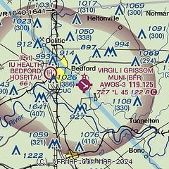
| Sectional chart |
|---|
|
| Airport distance calculator |
|---|
|
|
| Sunrise and sunset |
|---|
|
Times for 31-Jul-2026
| | Local
(UTC-4) | | Zulu
(UTC) |
|---|
| Morning civil twilight | | 06:17 | | 10:17 |
| Sunrise | | 06:47 | | 10:47 |
| Sunset | | 20:57 | | 00:57 |
| Evening civil twilight | | 21:27 | | 01:27 |
|
| Current date and time |
|---|
| Zulu (UTC) | 31-Jul-2026 13:20:07 |
|---|
| Local (UTC-4) | 31-Jul-2026 09:20:07 |
|---|
|
| METAR |
|---|
| KBFR | 311255Z AUTO 10002KT 10SM CLR 22/19 A3005 RMK AO2
|
|
| TAF |
|---|
KBMG
20nm NW | 311125Z 3112/0112 00000KT P6SM BKN250 FM311500 18007KT P6SM SCT050 BKN250 FM312200 18005KT P6SM BKN080 FM010000 13007KT P6SM VCSH BKN040 OVC080 FM010900 14006KT P6SM -SHRA OVC040
|
|
| NOTAMs |
|---|
NOTAMs are issued by the DoD/FAA and will open in a separate window not controlled by AirNav.
|
|

