FAA INFORMATION EFFECTIVE 09 JULY 2026
Location
| FAA Identifier: | BAK |
| Lat/Long: | 39-15-42.8940N 085-53-46.8200W
39-15.714900N 085-53.780333W
39.2619150,-85.8963389
(estimated) |
| Elevation: | 656.1 ft. / 200.0 m (surveyed) |
| Variation: | 03W (1995) |
| From city: | 3 miles N of COLUMBUS, IN |
| Time zone: | UTC -4 (UTC -5 during Standard Time) |
| Zip code: | 47203 |
Airport Operations
| Airport use: | Open to the public |
| Activation date: | 02/1944 |
| Control tower: | yes |
| ARTCC: | INDIANAPOLIS CENTER |
| FSS: | TERRE HAUTE FLIGHT SERVICE STATION |
| NOTAMs facility: | BAK (NOTAM-D service available) |
| Attendance: | SUN-THU 24 HOURS/DAY, ALL FRI-SAT 0600-2300
AFT HR - 812-372-1819. |
| Wind indicator: | lighted |
| Segmented circle: | no |
| Lights: | WHEN ATCT CLSD ACTVT MALSR RWY 23; REIL RWY 05, 14 & 32; HIRL RWY 05/23; MIRL RWY 14/32 - CTAF. PAPI RWY 5, 14, 23 & 32 ON CONSLY. |
| Beacon: | white-green (lighted land airport)
Operates sunset to sunrise. |
| Fire and rescue: | ARFF index A |
Airport Communications
| CTAF: | 118.6 |
| UNICOM: | 122.95 |
| WX AWOS-3: | 119.75 (812-376-7584) |
| COLUMBUS GROUND: | 121.6 [0630-2200] |
| COLUMBUS TOWER: | 118.6 [0630-2200] |
| INDIANAPOLIS APPROACH: | 134.85 |
| INDIANAPOLIS DEPARTURE: | 134.85 |
| CLEARANCE DELIVERY: | 134.85 ;CTC APCH CTL |
| WX AWOS-3 at OVO (19 nm SE): | 120.625 (812-346-5041) |
| WX ASOS at GEZ (20 nm N): | 121.55 (317-398-0246) |
- CLEARANCE DELIVERY FREQUENCY 134.85 USED WHEN ATCT CLSD.
Nearby radio navigation aids
| VOR radial/distance | | VOR name | | Freq | | Var |
|---|
| SHBr188/22.5 | | SHELBYVILLE VOR/DME | | 116.15 | | 01E |
| OOMr080/34.1 | | HOOSIER VORTAC | | 110.20 | | 02W |
| VHPr146/39.7 | | BRICKYARD VORTAC | | 116.30 | | 01E |
| NDB name | | Hdg/Dist | | Freq | | Var | | ID |
|---|
| CLIFS | | 228/5.1 | | 410 | | 03W | | BA | -... .- |
Airport Services
| Fuel available: | 100LL JET-A+ |
| Parking: | hangars and tiedowns |
| Airframe service: | MAJOR |
| Powerplant service: | MAJOR |
| Bulk oxygen: | HIGH/LOW |
Runway Information
Runway 5/23
| Dimensions: | 6401 x 150 ft. / 1951 x 46 m |
| Surface: | concrete/grooved, in excellent condition |
| Weight bearing capacity: | | Single wheel: | 75.0 | | Double wheel: | 130.0 | | Double tandem: | 200.0 |
|
| Runway edge lights: | high intensity |
| Operational restrictions: | RWY 05/23 NOT AVBL FOR PART 121/PART 380 OPS WITH SKED PAX CARRYING OPS MORE THAN 9 PAX SEATS AND NON-SKED PAX CARRYING OPS MORE THAN 30 PAX SEATS. 90 DAY PPR FOR UNSKED ACR OPS GTR THAN 30 PAX SEATS - CALL AMGR. 812-376-2519 OR 379-9942. MIL MARKINGS CMSND. |
| RUNWAY 5 | | RUNWAY 23 |
| Latitude: | 39-15.314360N | | 39-16.059340N |
| Longitude: | 085-54.292937W | | 085-53.333263W |
| Elevation: | 650.3 ft. | | 656.0 ft. |
| Traffic pattern: | left | | left |
| Runway heading: | 048 magnetic, 045 true | | 228 magnetic, 225 true |
| Declared distances: | TORA:6401 TODA:6401 ASDA:6401 LDA:6401 | | TORA:6401 TODA:6401 ASDA:6401 LDA:6401 |
| Markings: | precision, in good condition | | precision, in good condition |
| Visual slope indicator: | 4-light PAPI on left (3.00 degrees glide path) | | 4-light PAPI on left (3.00 degrees glide path) |
| Approach lights: | | | MALSR: 1,400 foot medium intensity approach lighting system with runway alignment indicator lights |
| Runway end identifier lights: | yes | | no |
| Touchdown point: | yes, no lights | | yes, no lights |
| Instrument approach: | | | ILS |
| Obstructions: | 74 ft. tower, 3040 ft. from runway, 94 ft. right of centerline, 38:1 slope to clear | | none |
Runway 14/32
| Dimensions: | 5000 x 100 ft. / 1524 x 30 m |
| Surface: | concrete/grooved, in excellent condition |
| Weight bearing capacity: | | Single wheel: | 120.0 | | Double wheel: | 171.0 | | Double tandem: | 290.0 | | Dual double tandem: | 735.0 |
|
| Runway edge lights: | medium intensity |
| Operational restrictions: | RWY 14/32 NOT AVBL FOR PART 121/PART 380 OPS WITH SKED PAX CARRYING OPS MORE THAN 9 PAX SEATS AND NON-SKED PAX CARRYING OPS MORE THAN 30 PAX SEATS. 90 DAY PPR FOR UNSKED ACR OPS GTR THAN 30 PAX SEATS - CALL AMGR. 812-376-2519 OR 379-9942. |
| RUNWAY 14 | | RUNWAY 32 |
| Latitude: | 39-16.042202N | | 39-15.459335N |
| Longitude: | 085-54.112603W | | 085-53.364080W |
| Elevation: | 654.5 ft. | | 651.5 ft. |
| Traffic pattern: | left | | left |
| Runway heading: | 138 magnetic, 135 true | | 318 magnetic, 315 true |
| Declared distances: | TORA:5000 TODA:5000 ASDA:5000 LDA:5000 | | TORA:5000 TODA:5000 ASDA:5000 LDA:5000 |
| Markings: | nonprecision, in good condition | | nonprecision, in good condition |
| Visual slope indicator: | 4-light PAPI on left (3.00 degrees glide path) | | 4-light PAPI on left (3.00 degrees glide path) |
| Runway end identifier lights: | yes | | yes |
| Touchdown point: | yes, no lights | | yes, no lights |
Airport Ownership and Management from official FAA records
| Ownership: | Publicly-owned |
| Owner: | CITY OF COLUMBUS
4770 RAY BOLL BLVD
COLUMBUS, IN 47203
Phone 812-376-2519 |
| Manager: | BRIAN PAYNE
4770 RAY BOLL BLVD
COLUMBUS, IN 47203
Phone 812-376-2519
812-379-9942 |
Additional Remarks
| A39-05/23 | PCR VALUE: 320/R/A/W/T |
| A39-14/32 | PCR VALUE: 300/R/A/W/T |
| - | SAWRS AVBL. |
| - | BIRDS ON & INVOF ARPT; HVY ACT AUG & SEP. |
| - | FICONS NOT MNTD 1700-0600. |
| - | ACFT SVCS - UNICOM. |
Instrument Procedures
NOTE: All procedures below are presented as PDF files. If you need a reader for these files, you should download the free Adobe Reader.NOT FOR NAVIGATION. Please procure official charts for flight.
FAA instrument procedures published for use from 09 July 2026 at 0901Z to 06 August 2026 at 0900Z.
IAPs - Instrument Approach Procedures |
|---|
| ILS OR LOC RWY 23 **CHANGED** | |
download (224KB) |
| RNAV (GPS) RWY 05 **CHANGED** | |
download (206KB) |
| RNAV (GPS) RWY 14 **CHANGED** | |
download (207KB) |
| RNAV (GPS) RWY 23 **CHANGED** | |
download (195KB) |
| RNAV (GPS) RWY 32 **CHANGED** | |
download (206KB) |
| NOTE: Special Alternate Minimums apply | |
download (131KB) |
| NOTE: Special Take-Off Minimums/Departure Procedures apply | |
download (164KB) |
Other nearby airports with instrument procedures:
I34 - Greensburg Municipal Airport (18 nm E)
KOVO - North Vernon Airport (19 nm SE)
KGEZ - Shelbyville Municipal Airport (20 nm N)
KSER - Freeman Municipal Airport (20 nm S)
KHFY - Indy South Greenwood Airport (24 nm N)
|
|

Road maps at:
MapQuest
Bing
Google
| Aerial photo |
|---|
WARNING: Photo may not be current or correct
 Photo by Phil Brooks
Photo taken 31-Jul-2015
looking east-northeast.
Photo by Phil Brooks
Photo taken 31-Jul-2015
looking east-northeast.
Do you have a better or more recent aerial photo of Columbus Municipal Airport that you would like to share? If so, please send us your photo.
|
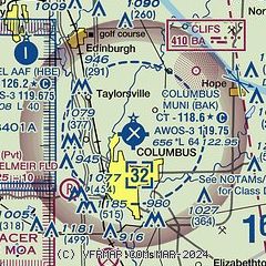
| Sectional chart |
|---|
|
CAUTION: Diagram may not be current
 Download PDF
of official airport diagram from the FAA
| Airport distance calculator |
|---|
|
|
| Sunrise and sunset |
|---|
|
Times for 13-Jul-2026
| | Local
(UTC-4) | | Zulu
(UTC) |
|---|
| Morning civil twilight | | 05:58 | | 09:58 |
| Sunrise | | 06:29 | | 10:29 |
| Sunset | | 21:10 | | 01:10 |
| Evening civil twilight | | 21:41 | | 01:41 |
|
| Current date and time |
|---|
| Zulu (UTC) | 13-Jul-2026 18:46:12 |
|---|
| Local (UTC-4) | 13-Jul-2026 14:46:12 |
|---|
|
| METAR |
|---|
| KBAK | 131745Z 02006KT 10SM CLR 29/21 A3017
|
KGEZ
20nm N | 131753Z AUTO 01009G15KT 10SM CLR 29/19 A3017 RMK AO2 SLP210 T02890194 10289 20189 56001
|
|
| TAF |
|---|
KIND
33nm NW | 131720Z 1318/1424 05012KT P6SM SKC FM140000 04007KT P6SM SKC FM140400 04003KT P6SM SKC FM141700 09004KT P6SM FEW050
|
KBMG
34nm W | 131720Z 1318/1418 04011KT P6SM FEW050 FM140000 04003KT P6SM SKC FM141600 08004KT P6SM FEW050
|
|
| NOTAMs |
|---|
NOTAMs are issued by the DoD/FAA and will open in a separate window not controlled by AirNav.
|
|


