FAA INFORMATION EFFECTIVE 11 JUNE 2026
Location
| FAA Identifier: | CPS |
| Lat/Long: | 38-34-13.3000N 090-09-18.3000W
38-34.221667N 090-09.305000W
38.5703611,-90.1550833
(estimated) |
| Elevation: | 412.9 ft. / 125.9 m (surveyed) |
| Variation: | 00E (2000) |
| From city: | 1 mile E of central business district of the associated city |
| Time zone: | UTC -5 (UTC -6 during Standard Time) |
| Zip code: | 62206 |
Airport Operations
| Airport use: | Open to the public |
| Activation date: | 04/1940 |
| Control tower: | yes |
| ARTCC: | KANSAS CITY CENTER |
| FSS: | SAINT LOUIS FLIGHT SERVICE STATION |
| NOTAMs facility: | CPS (NOTAM-D service available) |
| Attendance: | CONTINUOUS |
| Wind indicator: | lighted |
| Segmented circle: | yes |
| Lights: | ACTVT MALSR RWY 30L WHEN ATCT CLSD; REIL RWY 30R - CTAF. HIRL RWY 12R/30L PRESET MED INTST WHEN ATCT CLSD. MIRL RWY 12L & 30R NOT AVBL WHEN ATCT CLSD. PAPI RWY 12R & 30L OPR CONSLY. |
| Beacon: | white-green (lighted land airport)
Operates sunset to sunrise. |
| Fire and rescue: | ARFF index A |
| Airline operations: | CLSD TO SKED ACR OPS GTR THAN 9 PSGR SEATS. UNSKED ACR OPS GTR THAN 30 PSGR SEATS RQR 12 HR PPR. |
Airport Communications
| CTAF: | 119.925 |
| UNICOM: | 122.95 |
| ATIS: | 121.45 |
| WX ASOS: | PHONE 618-332-0001 |
| DOWNTOWN GROUND: | 121.8 [0630-2200] |
| DOWNTOWN TOWER: | 119.925 379.3 [0630-2200] |
| SAINT LOUIS APPROACH: | 123.7 |
| SAINT LOUIS DEPARTURE: | 123.7 |
| CLEARANCE DELIVERY: | 118.275 121.8 ;WHEN TWR CLSD |
| BUUDD STAR: | 119.15 |
| DELMA STAR: | 128.1 |
| DIXEE STAR: | 128.1 |
| FARMR STAR: | 119.15 |
| WX ASOS at STL (15 nm NW): | PHONE 314-238-8419 |
| WX AWOS-3PT at ALN (20 nm N): | 128.0 (618-259-7231) |
Nearby radio navigation aids
| VOR radial/distance | | VOR name | | Freq | | Var |
|---|
| TOYr224/15.0 | | TROY VORTAC | | 116.00 | | 04E |
| STLr138/23.2 | | ST LOUIS VORTAC | | 117.40 | | 01E |
| FTZr096/39.0 | | FORISTELL VORTAC | | 114.35 | | 05E |
| NDB name | | Hdg/Dist | | Freq | | Var | | ID |
|---|
| ACORE | | 304/5.4 | | 350 | | 00E | | CP | -.-. .--. |
Airport Services
| Fuel available: | 100LL JET-A |
| Parking: | hangars and tiedowns |
| Airframe service: | MAJOR |
| Powerplant service: | MAJOR |
| Bulk oxygen: | HIGH |
Runway Information
Runway 12R/30L
| Dimensions: | 7002 x 150 ft. / 2134 x 46 m |
| Surface: | asphalt/grooved, in excellent condition |
| Weight bearing capacity: | | Single wheel: | 96.0 | | Double wheel: | 125.0 | | Double tandem: | 182.0, 200 WITH PPR. |
|
| Runway edge lights: | high intensity |
| Operational restrictions: | W.B.C. GROSS WT (2S) 160. |
| RUNWAY 12R | | RUNWAY 30L |
| Latitude: | 38-34.440105N | | 38-33.825097N |
| Longitude: | 090-09.903908W | | 090-08.660762W |
| Elevation: | 412.4 ft. | | 408.0 ft. |
| Traffic pattern: | right | | left |
| Runway heading: | 122 | | 302 |
| Declared distances: | TORA:7002 TODA:7002 ASDA:7002 LDA:7002 | | TORA:7002 TODA:7002 ASDA:7002 LDA:7002 |
| Markings: | precision, in good condition | | precision, in good condition |
| Visual slope indicator: | 4-light PAPI on left (3.00 degrees glide path) | | 4-light PAPI on left (3.00 degrees glide path) |
| Approach lights: | | | MALSR: 1,400 foot medium intensity approach lighting system with runway alignment indicator lights |
| Runway end identifier lights: | yes | | no |
| Touchdown point: | yes, no lights | | yes, no lights |
| Instrument approach: | | | ILS |
| Obstructions: | 30 ft. tree, 809 ft. from runway, 487 ft. left of centerline, 20:1 slope to clear | | 29 ft. pole, 1688 ft. from runway, 362 ft. left of centerline, 36:1 slope to clear |
Runway 12L/30R
| Dimensions: | 5301 x 75 ft. / 1616 x 23 m |
| Surface: | concrete, in fair condition |
| Weight bearing capacity: | | PCN 10 /F/D/X/T | | Single wheel: | 30.0 | | Double wheel: | 30.0 |
|
| Runway edge lights: | medium intensity |
| Operational restrictions: | RWY 12L/30R NOT AVBL FOR PART 121/PART 380 OPS WITH SKED PAX CARRYING OPS MORE THAN 9 PAX SEATS AND NON-SKED PAX CARRYING OPS MORE THAN 30 PAX SEATS. NO PART 121/PART 380 OPS EXC FOR TAX. |
| RUNWAY 12L | | RUNWAY 30R |
| Latitude: | 38-34.426480N | | 38-33.960907N |
| Longitude: | 090-09.492553W | | 090-08.551543W |
| Elevation: | 410.0 ft. | | 406.5 ft. |
| Traffic pattern: | left | | right |
| Runway heading: | 122 | | 302 |
| Declared distances: | TORA:5300 TODA:5300 ASDA:5300 LDA:5300 | | TORA:5300 TODA:5300 ASDA:5300 LDA:5300 |
| Markings: | nonprecision, in fair condition | | nonprecision, in fair condition |
| Runway end identifier lights: | yes | | yes |
| Touchdown point: | yes, no lights | | yes, no lights |
| Obstructions: | 96 ft. tree, 3817 ft. from runway, 254 ft. left of centerline, 37:1 slope to clear | | 72 ft. tree, 2664 ft. from runway, 306 ft. right of centerline, 34:1 slope to clear |
Runway 5/23
| Dimensions: | 2799 x 75 ft. / 853 x 23 m |
| Surface: | asphalt, in fair condition |
| Weight bearing capacity: | | PCN 11 /R/C/W/T | | Single wheel: | 12.0 |
|
| Runway edge lights: | medium intensity |
| Runway edge markings: | SFC MARKINGS FADED. |
| Operational restrictions: | RWY 05/23 NOT AVBL FOR PART 121/PART 380 OPS WITH SKED PAX CARRYING OPS MORE THAN 9 PAX SEATS AND NON-SKED PAX CARRYING OPS MORE THAN 30 PAX SEATS. NO PART 121/PART 380 OPS EXC FOR TAX. |
| RUNWAY 5 | | RUNWAY 23 |
| Latitude: | 38-34.341392N | | 38-34.656068N |
| Longitude: | 090-10.111893W | | 090-09.682603W |
| Elevation: | 410.0 ft. | | 408.6 ft. |
| Traffic pattern: | left | | left |
| Runway heading: | 047 | | 227 |
| Declared distances: | TORA:2799 TODA:2799 ASDA:2799 LDA:2799 | | TORA:2799 TODA:2799 ASDA:2799 LDA:2799 |
| Markings: | basic, in poor condition | | basic, in poor condition |
| Runway end identifier lights: | no | | no |
| Touchdown point: | yes, no lights | | yes, no lights |
| Obstructions: | 54 ft. tree, 811 ft. from runway, 58 ft. right of centerline, 11:1 slope to clear | | 72 ft. tower, lighted, 1647 ft. from runway, 16 ft. right of centerline, 20:1 slope to clear |
Airport Ownership and Management from official FAA records
| Ownership: | Publicly-owned |
| Owner: | BI-STATE DEVELOPMENT AGENCY
6100 ARCHVIEW DRIVE
CAHOKIA, IL 62206-1445
Phone 618-337-6060 |
| Manager: | SANDRA SHORE
6100 ARCHVIEW DRIVE
CAHOKIA, IL 62206-1445
Phone 618-337-6060 |
Additional Remarks
| A39-12R/30L | PCR VALUE: 400/F/D/X/T |
| - | WATERFOWL ON & INVOF ARPT. |
| - | BE ALERT FOR STUDENT TRNG & HEL OPS. |
| - | ALL TWYS EXCP TWY B4 PPR ACFT OVER 120000 LBS. |
| - | SFC CONDS NOT MNTD 2100-0700 LCL. |
Instrument Procedures
NOTE: All procedures below are presented as PDF files. If you need a reader for these files, you should download the free Adobe Reader.NOT FOR NAVIGATION. Please procure official charts for flight.
FAA instrument procedures published for use from 11 June 2026 at 0901Z to 09 July 2026 at 0900z.
STARs - Standard Terminal Arrivals |
|---|
| BUUDD THREE (RNAV) **NEW** | |
download (296KB) |
| DELMA FOUR (RNAV) **NEW** | |
download (266KB) |
| DIXEE THREE (RNAV) **NEW** | |
download (170KB) |
| FARMR THREE (RNAV) **NEW** | |
download (208KB) |
IAPs - Instrument Approach Procedures |
|---|
| ILS OR LOC RWY 30L | |
download (287KB) |
| RNAV (GPS) RWY 12R | |
download (252KB) |
| RNAV (GPS) RWY 30L | |
download (312KB) |
| RNAV (GPS) RWY 30R | |
download (261KB) |
| NOTE: Special Alternate Minimums apply | |
download (58KB) |
Departure Procedures |
|---|
| GATEWAY ONE | |
2 pages:
[1] [2] (506KB) |
| LINDBERGH NINE | |
2 pages:
[1] [2] (343KB) |
| OZARK EIGHT | |
2 pages:
[1] [2] (321KB) |
| PLESS FIVE | |
download (279KB) |
| NOTE: Special Take-Off Minimums/Departure Procedures apply | |
download (201KB) |
Other nearby airports with instrument procedures:
KSTL - St Louis Lambert International Airport (15 nm NW)
KBLV - Scott Air Force Base/MidAmerica Airport (15 nm E)
1H0 - Creve Coeur Airport (19 nm NW)
KALN - St Louis Regional Airport (20 nm N)
KSUS - Spirit of St Louis Airport (24 nm W)
|
|

Road maps at:
MapQuest
Bing
Google
| Aerial photo |
|---|
WARNING: Photo may not be current or correct
 Photo by David Heon
looking north.
Photo by David Heon
looking north.
Do you have a better or more recent aerial photo of St Louis Downtown Airport that you would like to share? If so, please send us your photo.
|
| Sectional chart |
|---|
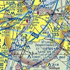
|
CAUTION: Diagram may not be current
 Download PDF
of official airport diagram from the FAA
| Airport distance calculator |
|---|
|
|
| Sunrise and sunset |
|---|
|
Times for 12-Jun-2026
| | Local
(UTC-5) | | Zulu
(UTC) |
|---|
| Morning civil twilight | | 05:05 | | 10:05 |
| Sunrise | | 05:37 | | 10:37 |
| Sunset | | 20:24 | | 01:24 |
| Evening civil twilight | | 20:56 | | 01:56 |
|
| Current date and time |
|---|
| Zulu (UTC) | 12-Jun-2026 22:56:01 |
|---|
| Local (UTC-5) | 12-Jun-2026 17:56:01 |
|---|
|
| METAR |
|---|
| KCPS | 122153Z 31005KT 10SM CLR 29/13 A2998 RMK AO2 SLP148 T02890133 $
|
KSTL
15nm NW | 122151Z 32010KT 10SM FEW060 FEW250 28/14 A3000 RMK AO2 SLP148 T02830139 $
|
KBLV
15nm E | 122155Z AUTO 33008KT 10SM CLR 28/15 A2997 RMK AO2 SLP148 T02840146 $
|
KALN
20nm N | 122145Z 33005KT 10SM CLR 28/13 A3000
|
|
| TAF |
|---|
| KCPS | 121720Z 1218/1318 VRB03KT P6SM SKC FM131200 18006KT P6SM BKN100
|
KSTL
15nm NW | 122105Z 1221/1324 VRB04KT P6SM SKC FM131200 18006KT P6SM BKN100
|
KBLV
15nm E | 121600Z 1216/1322 34009KT 9999 SKC QNH2992INS BECMG 1301/1302 14006KT 9999 SCT060 BKN200 QNH2997INS BECMG 1317/1318 15012KT 9000 -SHRA BKN060 OVC200 QNH2998INS TX29/1221Z TN17/1312Z
|
|
| NOTAMs |
|---|
NOTAMs are issued by the DoD/FAA and will open in a separate window not controlled by AirNav.
|
|


