FAA INFORMATION EFFECTIVE 16 APRIL 2026
Location
| FAA Identifier: | 2H0 |
| Lat/Long: | 39-24-40.6900N 088-50-43.8800W
39-24.678167N 088-50.731333W
39.4113028,-88.8455222
(estimated) |
| Elevation: | 618.9 ft. / 188.6 m (surveyed) |
| Variation: | 02W (2010) |
| From city: | 3 miles W of SHELBYVILLE, IL |
| Time zone: | UTC -5 (UTC -6 during Standard Time) |
| Zip code: | 62565 |
Airport Operations
| Airport use: | Open to the public |
| Activation date: | 11/1947 |
| Control tower: | no |
| ARTCC: | KANSAS CITY CENTER |
| FSS: | SAINT LOUIS FLIGHT SERVICE STATION |
| NOTAMs facility: | STL (NOTAM-D service available) |
| Attendance: | 0800-DUSK |
| Pattern altitude: | 1418.9 ft. MSL |
| Wind indicator: | lighted |
| Segmented circle: | no |
| Lights: | ACTVT PAPI RWY 36; MIRL 18/36 - CTAF. |
| Beacon: | white-green (lighted land airport)
Operates sunset to sunrise. |
Airport Communications
- APCH/DEP SVC PRVDD BY KANSAS CITY ARTCC ON FREQS 124.3/269.15 (DECATUR RCAG).
Nearby radio navigation aids
| VOR radial/distance | | VOR name | | Freq | | Var |
|---|
| AXCr176/19.6 | | ADDERS VORTAC | | 117.20 | | 03E |
| BIBr327/34.0 | | BIBLE GROVE VORTAC | | 109.00 | | 03E |
| NDB name | | Hdg/Dist | | Freq | | Var | | ID |
|---|
| SHELBYVILLE | | at field | | 365 | | 02W | | SYZ | ... -.-- --.. |
Airport Services
| Fuel available: | 100LL JET-A+
100LL:SELF SVC FUEL AVBL 24 HRS WITH CREDIT CARD. |
| Parking: | hangars and tiedowns |
| Airframe service: | MAJOR |
| Powerplant service: | MAJOR |
| Bottled oxygen: | NONE |
| Bulk oxygen: | NONE |
Runway Information
Runway 18/36
| Dimensions: | 4098 x 75 ft. / 1249 x 23 m |
| Surface: | asphalt/porous friction courses, in good condition |
| Weight bearing capacity: | |
| Runway edge lights: | medium intensity |
| RUNWAY 18 | | RUNWAY 36 |
| Latitude: | 39-25.095878N | | 39-24.420897N |
| Longitude: | 088-50.853115W | | 088-50.847975W |
| Elevation: | 618.4 ft. | | 618.5 ft. |
| Traffic pattern: | left | | left |
| Runway heading: | 182 magnetic, 180 true | | 002 magnetic, 360 true |
| Markings: | nonprecision, in good condition | | nonprecision, in good condition |
| Visual slope indicator: | | | 2-light PAPI on left (4.00 degrees glide path) |
| Runway end identifier lights: | no | | no |
| Touchdown point: | yes, no lights | | yes, no lights |
Runway 14/32
| Dimensions: | 2336 x 180 ft. / 712 x 55 m |
| Surface: | turf, in good condition |
| RUNWAY 14 | | RUNWAY 32 |
| Latitude: | 39-24.714563N | | 39-24.421200N |
| Longitude: | 088-50.770798W | | 088-50.449810W |
| Elevation: | 617.0 ft. | | 612.9 ft. |
| Traffic pattern: | left | | left |
| Runway heading: | 142 magnetic, 140 true | | 322 magnetic, 320 true |
| Markings: | none | | none |
| Runway end identifier lights: | no | | no |
| Touchdown point: | yes, no lights | | yes, no lights |
| Obstructions: | none | | 42 ft. tree, 688 ft. from runway, 140 ft. left of centerline, 16:1 slope to clear
APCH RATIO 20:1 TO DSPLCD THLD; 33 FT ANT 665 FT FM DSPLCD THLD 179 FT L OF CNTRLN. |
Runway 4/22
| Dimensions: | 1446 x 180 ft. / 441 x 55 m |
| Surface: | turf, in good condition |
| RUNWAY 4 | | RUNWAY 22 |
| Latitude: | 39-24.537782N | | 39-24.720210N |
| Longitude: | 088-50.687613W | | 088-50.490192W |
| Elevation: | 615.2 ft. | | 612.8 ft. |
| Traffic pattern: | left | | left |
| Runway heading: | 042 magnetic, 040 true | | 222 magnetic, 220 true |
| Markings: | none | | none |
| Runway end identifier lights: | no | | no |
| Touchdown point: | yes, no lights | | yes, no lights |
Airport Ownership and Management from official FAA records
| Ownership: | Publicly-owned |
| Owner: | SHELBY CO ARPT & LNDG CMSN.
PO BOX 174
ASSUMPTION, IL 62510
Phone 217-774-5111 |
| Manager: | SCOTT JEFSON
1147 N 1915 EAST ROAD
SHELBYVILLE, IL 62565
Phone 217-774-5111
ALTERNATE PHONE NUMBER: 217-827-1196 |
Additional Remarks
| - | BOUNDARIES FOR RYS 4/22 & 14/32 ARE MARKED WITH WHITE PAINTED TIRES SPACED AT 400 FT INTERVALS. |
| - | RY 4 RELOCATED THLD NE OF TWYS. NEW RY LENGTHS PENDING RY 4/22. |
| - | WHEN ARPT UNATNDD, PHONE NR FOR ASSISTANCE POSTED ON FBO DOORS. |
| - | FOR CD CTC KANSAS CITY ARTCC AT 913-254-8508. |
| - | WEATHER AVBL 4 CLICKS ON CTAF, SAY WEATHER. |
Instrument Procedures
NOTE: All procedures below are presented as PDF files. If you need a reader for these files, you should download the free Adobe Reader.NOT FOR NAVIGATION. Please procure official charts for flight.
FAA instrument procedures published for use from 16 April 2026 at 0901Z to 14 May 2026 at 0900Z.
IAPs - Instrument Approach Procedures |
|---|
| RNAV (GPS) RWY 36 | |
download (224KB) |
| NDB-A | |
download (177KB) |
| NOTE: Special Take-Off Minimums/Departure Procedures apply | |
download (201KB) |
Other nearby airports with instrument procedures:
KTAZ - Taylorville Municipal Airport (24 nm W)
1H2 - Effingham County Regional Airport (25 nm SE)
KDEC - Decatur Airport (25 nm N)
KMTO - Coles County Memorial Airport (27 nm E)
KVLA - Vandalia Municipal Airport (29 nm SW)
|
|

Road maps at:
MapQuest
Bing
Google
| Aerial photo |
|---|
WARNING: Photo may not be current or correct

Do you have a better or more recent aerial photo of Shelby County Airport that you would like to share? If so, please send us your photo.
|
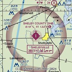
| Sectional chart |
|---|
|
| Airport distance calculator |
|---|
|
|
| Sunrise and sunset |
|---|
|
Times for 18-Apr-2026
| | Local
(UTC-5) | | Zulu
(UTC) |
|---|
| Morning civil twilight | | 05:47 | | 10:47 |
| Sunrise | | 06:15 | | 11:15 |
| Sunset | | 19:35 | | 00:35 |
| Evening civil twilight | | 20:03 | | 01:03 |
|
| Current date and time |
|---|
| Zulu (UTC) | 18-Apr-2026 20:02:22 |
|---|
| Local (UTC-5) | 18-Apr-2026 15:02:22 |
|---|
|
| METAR |
|---|
KTAZ
24nm W | 181939Z AUTO 29016G24KT 10SM CLR 11/02 A3007 RMK AO2
|
K1H2
25nm SE | 181955Z AUTO 28011G19KT 10SM CLR 12/04 A3006 RMK AO2 T01160035
|
KDEC
25nm N | 181954Z 30022G30KT 10SM CLR 12/01 A3004 RMK AO2 PK WND 28030/1933 SLP170 T01170006
|
KMTO
27nm E | 181953Z AUTO 29020G29KT 10SM CLR 11/02 A3003 RMK AO2 PK WND 27032/1854 SLP170 T01060022
|
K3LF
41nm W | 181955Z AUTO 28017G21KT 10SM CLR 12/01 A3009 RMK AO2 T01190013
|
KCMI
46nm NE | 181953Z AUTO 29019G29KT 10SM CLR 11/02 A3001 RMK AO2 PK WND 30029/1902 SLP162 T01060022
|
KSLO
46nm S | 181955Z AUTO 30011G18KT 10SM CLR 13/03 A3007 RMK AO2 T01270033
|
KSPI
47nm NW | 181952Z 30016G32KT 10SM CLR 11/M01 A3006 RMK AO2 PK WND 27032/1946 SLP180 T01111006
|
|
| TAF |
|---|
KDEC
25nm N | 181720Z 1818/1918 30016G24KT P6SM FEW250 FM190200 29008KT P6SM SKC FM191700 28013G22KT P6SM SCT170
|
|
| NOTAMs |
|---|
NOTAMs are issued by the DoD/FAA and will open in a separate window not controlled by AirNav.
|
|

