FAA INFORMATION EFFECTIVE 25 DECEMBER 2025
Location
| FAA Identifier: | FBG |
| Lat/Long: | 35-07-55.5450N 078-56-07.2450W
35-07.925750N 078-56.120750W
35.1320958,-78.9353458
(estimated) |
| Elevation: | 243.3 ft. / 74 m (estimated) |
| Variation: | 09W (2025) |
| From city: | 4 miles E of FORT BRAGG, NC |
| Time zone: | UTC -5 (UTC -4 during Daylight Saving Time) |
| Zip code: | 28311 |
Airport Operations
| Airport use: | Private use. Permission required prior to landing |
| Control tower: | yes |
| ARTCC: | WASHINGTON CENTER |
| FSS: | RALEIGH FLIGHT SERVICE STATION |
| NOTAMs facility: | FBG (NOTAM-D service available) |
| Attendance: | MON-SAT 1200-0500Z++
CLSD HOL, OT BY NOTAM. SEE FLIP AP/1 FLT HAZ AND SUPPLEMENTARY ARPT RMK. |
| Segmented circle: | no |
| Lights: | REIL RWY 28; PAPI RWY 28; MIRL RWY 10/28 - OPER DRNG TWR HRS. |
| Beacon: | white-white-green (lighted military airport)
Operates sunset to sunrise. |
Airport Communications
| CTAF: | 125.9 |
| ATIS: | 139.25 |
| SIMMONS TWR GROUND: | 121.9 229.4 [1310-0500Z++ MON-SAT. CLSD HOL, OTR TIMES BY NOTAM.] |
| SIMMONS TWR TOWER: | 125.9 240.625 [1310-0500Z++ MON-SAT. CLSD HOL, OTR TIMES BY NOTAM.] |
| FAYETTEVILLE APPROACH: | 133.0 |
| FAYETTEVILLE DEPARTURE: | 133.0 |
| CLEARANCE DELIVERY: | 121.9 229.4 |
| ADZY: | 125.9 240.625 |
| BASE OPS: | 142.35 245.5 |
| EMERG: | 121.5 243.0 |
| PAR: | 124.2 |
| PMSV METRO: | 141.25 265.6 |
| WX ASOS at FAY (9 nm S): | 121.25 (910-484-1546) |
| WX AWOS-3 at HRJ (18 nm NE): | 119.025 (910-814-3946) |
- FULL SVC DUR OPR HR, OT REMOTE BRIEFING FR 28TH OWS, SHAW AFB, SC, DSN 965-0940, C803-895-0940.
Nearby radio navigation aids
| VOR radial/distance | | VOR name | | Freq | | Var |
|---|
| FAYr345/9.3 | | FAYETTEVILLE VOR/DME | | 114.85 | | 04W |
| SDZr102/32.4 | | SANDHILLS VORTAC | | 111.80 | | 03W |
| NDB name | | Hdg/Dist | | Freq | | Var | | ID |
|---|
| HARNETT | | 223/22.1 | | 417 | | 08W | | HQT | .... --.- - |
| CLINTON | | 297/29.7 | | 412 | | 09W | | CTZ | -.-. - --.. |
Airport Services
| Fuel available: | A+ |
| Oil available: | CTAF WHEN TWR CLSD. |
Runway Information
Runway 10/28
| Dimensions: | 4121 x 100 ft. / 1256 x 30 m |
| Surface: | asphalt, in good condition
RSTD: RWY R/W ACFT ONLY. |
| Weight bearing capacity: | |
| Runway edge lights: | medium intensity |
| RUNWAY 10 | | RUNWAY 28 |
| Latitude: | 35-07.901667N | | 35-07.949833N |
| Longitude: | 078-56.533000W | | 078-55.708500W |
| Elevation: | 239.8 ft. | | 223.1 ft. |
| Traffic pattern: | left | | left |
| Runway heading: | 095 magnetic, 086 true | | 275 magnetic, 266 true |
| Markings: | precision, in good condition | | precision, in good condition |
| Visual slope indicator: | | | 2-light PAPI on left (3.00 degrees glide path) |
| Runway end identifier lights: | | | yes |
| Touchdown point: | yes, no lights | | yes, no lights |
Airport Ownership and Management from official FAA records
| Ownership: | U.S. Army |
| Owner: | US ARMY ATCA-ASO
9325 GUNSTON ROAD
FT BELVIOR, VA 22060 |
| Manager: | LARRY E LEWIS
SIMMONS AAAF BLDG P4541
FT BRAGG, NC 28307
Phone 910-396-6605 |
Additional Remarks
| - | FUEL: J8, 24 HR PPR FOR COLD FUEL. HOT REFUEL AVBL MON-FRI 1200Z-0400Z++. |
| - | RSTD: V22 RESTRICTIONS SEE AP/1. |
| - | MISC: ALL WEEKEND FUEL REQUEST ARE REQUIRED TO BE SUBMITTED TO BASE OPS BY TUES 1500L. |
| - | CAUTION: DISTANCE BETWEEN C/L AND 10/28 AND HELIPADS E AND W DOES NOT MEET STANDARDS. DISTANCE BETWEEN C/L AND HELIPADS IS 350 FT. NO SIMULTANEOUS OPS AUTH DUR VFR CONDS WHEN THE TWR IS NOT OPER. A PORTION OF TWY JULIET NORTH IS NOT LIT, AIRCREWS TAXI AT YOUR OWN RISK DURING IFR CONDS AND AT NIGHT. |
| - | FULL WX SVC AVBL 0500Z++ MON THRU 0500Z++ SAT, EXC FEDERAL HOL, DSN 236-7100/7414, C910-396-7100/7414. OT REMOTE BRIEFING FR STAND-BY FCSTR, C910-920-0116. |
| - | RSTD: 24 HR PPR FOR RON AND ALL CIV ACFT, DSN 236-7804, C910-396-7804. |
| - | CAUTION: ARPT PERIMETER LGT MAY CAUSE PILOT DISTRACTION. |
| - | TFC PAT: R/W 1000 FT. |
| - | MISC: PILOTS NOTIFY SIMMONS OPS 20 MIN OUT WITH CODE 6 OR ABV ON BOARD. |
| - | MISC: ALL WHEELED ROTO WING ACFT GND TAXI ON ALL RAMPS AND TWYS. |
| - | WHEN TWR AND/OR SFC VIS IS BLO 4 SM THE LESSER VALUE WILL BE RPRTD AS PVLING. |
| - | CAUTION: BIRD HAZARD. |
| - | MISC: 26 OWS BARKSDALE AFB, LA, DSN 331-2651, C318-529-2651. DSN 331-2651/2/3, C866-223-9328. |
Instrument Procedures
NOTE: All procedures below are presented as PDF files. If you need a reader for these files, you should download the free Adobe Reader.NOT FOR NAVIGATION. Please procure official charts for flight.
FAA instrument procedures published for use from 25 December 2025 at 0901z to 22 January 2026 at 0900z.
IAPs - Instrument Approach Procedures |
|---|
| RNAV (GPS) RWY 10 | |
download (106KB) |
| RNAV (GPS) RWY 28 | |
download (118KB) |
| NOTE: Special Take-Off Minimums/Departure Procedures apply | |
download (393KB) |
Other nearby airports with instrument procedures:
KPOB - Pope Army Airfield (5 nm NW)
KFAY - Fayetteville Regional Airport/Grannis Field (9 nm S)
5W4 - P K Airpark (14 nm SW)
KHRJ - Harnett Regional Jetport Airport (18 nm NE)
KSOP - Moore County Airport (23 nm W)
|
|

Road maps at:
MapQuest
Bing
Google
| Aerial photo |
|---|
WARNING: Photo may not be current or correct

Do you have a better or more recent aerial photo of Simmons Army Airfield that you would like to share? If so, please send us your photo.
|
| Sectional chart |
|---|
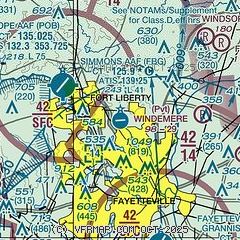
|
 Download PDF
of official airport diagram from the FAA
| Airport distance calculator |
|---|
|
|
| Sunrise and sunset |
|---|
|
Times for 10-Jan-2026
| | Local
(UTC-5) | | Zulu
(UTC) |
|---|
| Morning civil twilight | | 06:58 | | 11:58 |
| Sunrise | | 07:26 | | 12:26 |
| Sunset | | 17:21 | | 22:21 |
| Evening civil twilight | | 17:49 | | 22:49 |
|
| Current date and time |
|---|
| Zulu (UTC) | 10-Jan-2026 08:08:48 |
|---|
| Local (UTC-5) | 10-Jan-2026 03:08:48 |
|---|
|
| METAR |
|---|
| KFBG | 100755Z AUTO 00000KT 6SM BR CLR 17/16 A3014 RMK AO2 SLPNO T01670156 $
|
KPOB
4nm NW | 100755Z AUTO 20004KT 10SM CLR 17/16 A3015 RMK AO2 SLP212 T01700163 $
|
KFAY
9nm S | 100753Z AUTO 20007KT 7SM SCT055 16/16 A3016 RMK AO2 SLP206 T01610156
|
KHRJ
18nm NE | 100755Z AUTO 00000KT 3 1/2SM BR SCT060 SCT085 15/15 A3018 RMK AO2 T01490147
|
|
| TAF |
|---|
| KFBG | 100200Z 1002/1108 22009KT 9999 BKN030 QNH3017INS TEMPO 1003/1006 9000 -DZ OVC010 BECMG 1013/1014 19012G18KT 9999 OVC020 QNH3014INS TEMPO 1014/1018 OVC005 BECMG 1017/1018 19015G25KT 9999 SCT020 QNH3004INS TX24/1021Z TN14/1011Z
|
KPOB
4nm NW | 100200Z 1002/1108 VRB05KT 9999 SCT040 BKN200 QNH3010INS BECMG 1009/1010 20005KT 8000 BR SCT006 OVC010 QNH3008INS BECMG 1012/1013 20009KT 9999 NSW SCT007 OVC012 QNH3006INS BECMG 1014/1015 20012G18KT 9999 OVC015 QNH2998INS BECMG 1016/1017 20015G25KT 9999 SCT020 BKN040 BKN200 QNH2992INS BECMG 1100/1101 23012G22KT 9999 VCSH SCT015 BKN040 BKN120 BKN200 QNH2990INS TX25/1020Z TN14/1008Z LAST NO AMDS AFT 1003 NEXT 1218
|
KFAY
9nm S | 100538Z 1006/1106 18005KT P6SM BKN250 FM100900 18003KT 4SM BR OVC007 FM101100 18003KT 1/2SM FG OVC003 FM101400 19011KT P6SM OVC015 FM101700 20015G25KT P6SM OVC035
|
|
| NOTAMs |
|---|
NOTAMs are issued by the DoD/FAA and will open in a separate window not controlled by AirNav.
|
|


