FAA INFORMATION EFFECTIVE 14 MAY 2026
Location
| FAA Identifier: | 5W4 |
| Lat/Long: | 35-01-11.4950N 079-11-27.6140W
35-01.191583N 079-11.460233W
35.0198597,-79.1910039
(estimated) |
| Elevation: | 304 ft. / 92.7 m (surveyed) |
| Variation: | 09W (2020) |
| From city: | 3 miles NE of RAEFORD, NC |
| Time zone: | UTC -4 (UTC -5 during Standard Time) |
| Zip code: | 28376 |
Airport Operations
| Airport use: | Open to the public |
| Activation date: | 05/1964 |
| Control tower: | no |
| ARTCC: | WASHINGTON CENTER |
| FSS: | RALEIGH FLIGHT SERVICE STATION |
| NOTAMs facility: | RDU (NOTAM-D service available) |
| Attendance: | 0830-DUSK |
| Wind indicator: | lighted |
| Segmented circle: | yes |
| Lights: | SS-SR |
| Beacon: | white-green (lighted land airport)
Operates sunset to sunrise. |
Airport Communications
| CTAF/UNICOM: | 123.0 |
| FAYETTEVILLE APPROACH: | 127.8 |
| FAYETTEVILLE DEPARTURE: | 127.8 |
| WX ASOS at HFF (15 nm W): | 141.25 (910-396-7804) |
| WX ASOS at FAY (15 nm E): | 121.25 (910-484-1546) |
| WX ASOS at MEB (16 nm SW): | 134.125 (910-844-5338) |
| WX AWOS-3PT at SOP (16 nm NW): | 127.575 (910-692-4287) |
Nearby radio navigation aids
| VOR radial/distance | | VOR name | | Freq | | Var |
|---|
| FAYr282/15.7 | | FAYETTEVILLE VOR/DME | | 114.85 | | 04W |
| SDZr124/22.7 | | SANDHILLS VORTAC | | 111.80 | | 03W |
Airport Services
| Fuel available: | 100LL JET-A+ |
| Parking: | tiedowns |
| Airframe service: | NONE |
| Powerplant service: | NONE |
| Bottled oxygen: | NONE |
| Bulk oxygen: | NONE |
Runway Information
Runway 4/22
| Dimensions: | 3402 x 60 ft. / 1037 x 18 m |
| Surface: | asphalt, in excellent condition |
| Weight bearing capacity: | |
| Runway edge lights: | medium intensity |
| RUNWAY 4 | | RUNWAY 22 |
| Latitude: | 35-00.956983N | | 35-01.426050N |
| Longitude: | 079-11.647300W | | 079-11.273650W |
| Elevation: | 292.0 ft. | | 304.0 ft. |
| Traffic pattern: | left | | right |
| Runway heading: | 042 magnetic, 033 true | | 222 magnetic, 213 true |
| Markings: | nonprecision, in good condition | | nonprecision, in good condition |
| Touchdown point: | yes, no lights | | yes, no lights |
| Obstructions: | 56 ft. trees, 589 ft. from runway, 84 ft. right of centerline, 6:1 slope to clear | | 39 ft. trees, 615 ft. from runway, 32 ft. left of centerline, 10:1 slope to clear
20 FT BRUSH 0-200 FT FM THR 121 FT RIGHT OF CNTRLN. |
Airport Ownership and Management from official FAA records
| Ownership: | Privately-owned |
| Owner: | BILLIE THACKER
PO DRAWER 1510
RAEFORD, NC 28376
Phone 910-875-3261 |
| Manager: | JOEY D'ANNUNZIO
155 AIRPORT DRIVE
RAEFORD, NC 28376
Phone (910) 904-0000 |
Additional Remarks
| - | CTN: LOW FLYING MIL ACFT OPS IN VCNTY; ARPT LCTD WI FT. LIBERTY SOUTH B MOA. |
| - | FQT PAJA TO TARGET 300 FT SE OF TRML APN. |
| - | ACFT IN VCNTY MNT 123.5. |
| - | FLY ONE MILE DOWNWIND LEG TO PREVENT CONFLICTS WITH PAJA (DROP ZONE SOUTHEAST FM RWY). |
| - | AFT HRS SVC 910-578-4401. |
| - | MNT FREQ 123.5 FOR PAJA. |
| - | FOR CD CTC WASHINGTON ARTCC AT 703-771-3587. |
| - | CTN DO NOT OVERFLY AIRPORT DUE TO PAJA. |
Instrument Procedures
NOTE: All procedures below are presented as PDF files. If you need a reader for these files, you should download the free Adobe Reader.NOT FOR NAVIGATION. Please procure official charts for flight.
FAA instrument procedures published for use from 14 May 2026 at 0901Z to 11 June 2026 at 0900Z.
IAPs - Instrument Approach Procedures |
|---|
| RNAV (GPS)-A | |
download (137KB) |
| VOR-A | |
download (158KB) |
| NOTE: Special Take-Off Minimums/Departure Procedures apply | |
download (141KB) |
Other nearby airports with instrument procedures:
KPOB - Pope Army Airfield (13 nm NE)
KFBG - Simmons Army Airfield (14 nm NE)
KHFF - Mackall Army Airfield (15 nm W)
KFAY - Fayetteville Regional Airport/Grannis Field (15 nm E)
KMEB - Laurinburg/Maxton Airport (16 nm SW)
KSOP - Moore County Airport (16 nm NW)
|
|

Road maps at:
MapQuest
Bing
Google
| Aerial photo |
|---|
WARNING: Photo may not be current or correct
 Photo by Kelvin Draughon
Photo taken 25-Dec-2016
looking northeast.
Photo by Kelvin Draughon
Photo taken 25-Dec-2016
looking northeast.
Do you have a better or more recent aerial photo of P K Airpark that you would like to share? If so, please send us your photo.
|
| Sectional chart |
|---|
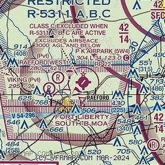
|
| Airport distance calculator |
|---|
|
|
| Sunrise and sunset |
|---|
|
Times for 04-Jun-2026
| | Local
(UTC-4) | | Zulu
(UTC) |
|---|
| Morning civil twilight | | 05:35 | | 09:35 |
| Sunrise | | 06:04 | | 10:04 |
| Sunset | | 20:26 | | 00:26 |
| Evening civil twilight | | 20:55 | | 00:55 |
|
| Current date and time |
|---|
| Zulu (UTC) | 04-Jun-2026 05:43:07 |
|---|
| Local (UTC-4) | 04-Jun-2026 01:43:07 |
|---|
|
| METAR |
|---|
KPOB
12nm NE | 040455Z AUTO 00000KT 10SM CLR 17/10 A3020 RMK AO2 SLP228 T01660100 402850088 $
|
KFBG
15nm NE | 040455Z AUTO 09003KT 10SM CLR 18/11 A3020 RMK AO2 SLP228 T01750106 402860101 $
|
KHFF
15nm W | 040455Z AUTO 00000KT 10SM CLR 13/11 A3019 RMK AO2 SLP224 T01330108 402800073 $
|
KFAY
15nm E | 040453Z 15005KT 10SM CLR 17/09 A3021 RMK AO2 SLP225 T01670094 402830117
|
KSOP
16nm NW | 040456Z AUTO 00000KT 10SM CLR 14/11 A3023 RMK AO2 SLP240 T01440111 $
|
KMEB
17nm SW | 040452Z AUTO 10003KT 10SM CLR 14/10 A3023 RMK AO2 SLP234 T01440100 402830067
|
|
| TAF |
|---|
KPOB
12nm NE | 040100Z 0401/0507 02006KT 9999 SKC QNH3006INS TX31/0420Z TN12/0410Z LAST NO AMDS AFT 0402 NEXT 0417
|
KFBG
15nm NE | 040100Z 0401/0507 03006KT 9999 SKC QNH3008INS TX31/0420Z TN14/0410Z
|
KFAY
15nm E | 031740Z 0318/0418 02009G18KT P6SM SCT080 FM032300 01004KT P6SM SKC
|
|
| NOTAMs |
|---|
NOTAMs are issued by the DoD/FAA and will open in a separate window not controlled by AirNav.
|
|

