FAA INFORMATION EFFECTIVE 14 MAY 2026
Location
| FAA Identifier: | FFL |
| Lat/Long: | 41-03-20.5914N 091-58-50.9585W
41-03.343190N 091-58.849308W
41.0557198,-91.9808218
(estimated) |
| Elevation: | 800.9 ft. / 244.1 m (surveyed) |
| Variation: | 00E (2010) |
| From city: | 3 miles NW of FAIRFIELD, IA |
| Time zone: | UTC -5 (UTC -6 during Standard Time) |
| Zip code: | 52556 |
Airport Operations
| Airport use: | Open to the public |
| Activation date: | 05/1967 |
| Control tower: | no |
| ARTCC: | CHICAGO CENTER |
| FSS: | FORT DODGE FLIGHT SERVICE STATION |
| NOTAMs facility: | FFL (NOTAM-D service available) |
| Attendance: | MON-FRI 0730-1630, ALL SAT - SUN ON CALL
ARPT UNATNDD ALL MAJOR HOLIDAYS |
| Pattern altitude: | 1801.9 ft. MSL |
| Wind indicator: | lighted |
| Segmented circle: | yes |
| Lights: | ACTVT MIRL RY 18/36; PAPI AND REIL RYS 18 & 36 - CTAF. |
| Beacon: | white-green (lighted land airport)
Operates sunset to sunrise. |
Airport Communications
| CTAF/UNICOM: | 122.7 |
| WX AWOS-3: | 132.025 (641-472-4548) |
| WX AWOS-3 at AWG (19 nm NE): | 127.825 (319-653-4149) |
- APCH/DEP SVC PRVDD BY CHICAGO ARTCC ON FREQS 118.15/335.575 (OTTUMWA RCAG).
Nearby radio navigation aids
| VOR radial/distance | | VOR name | | Freq | | Var |
|---|
| IOWr206/32.4 | | IOWA CITY VOR/DME | | 116.20 | | 05E |
Airport Services
| Fuel available: | 100LL JET-A |
| Parking: | hangars and tiedowns |
| Airframe service: | MAJOR |
| Powerplant service: | MAJOR |
| Bottled oxygen: | NONE |
Runway Information
Runway 18/36
| Dimensions: | 5503 x 100 ft. / 1677 x 30 m |
| Surface: | concrete, in good condition |
| Weight bearing capacity: | | PCN 16 /R/C/W/T | | Single wheel: | 30.0 | | Double wheel: | 45.0 |
|
| Runway edge lights: | medium intensity |
| RUNWAY 18 | | RUNWAY 36 |
| Latitude: | 41-03.868753N | | 41-02.962633N |
| Longitude: | 091-58.811235W | | 091-58.803292W |
| Elevation: | 797.2 ft. | | 791.6 ft. |
| Traffic pattern: | left | | left |
| Runway heading: | 180 | | 360 |
| Markings: | nonprecision, in good condition | | nonprecision, in good condition |
| Visual slope indicator: | 4-light PAPI on left (3.00 degrees glide path) | | 4-light PAPI on left (3.00 degrees glide path) |
| Runway end identifier lights: | yes | | yes |
| Touchdown point: | yes, no lights | | yes, no lights |
| Obstructions: | none | | 17 ft. road, 1054 ft. from runway |
Runway 8/26
| Dimensions: | 2505 x 140 ft. / 764 x 43 m |
| Surface: | turf, in good condition |
| Runway edge markings: | 08/26 THRS & EDGES MARKED WITH YELLOW CONES. THR CONES HAVE RED/GREEN REFLECTOR TAPE & EDGE CONES HAVE WHITE. |
| Operational restrictions: | CLSD NOV-MAR. |
| RUNWAY 8 | | RUNWAY 26 |
| Latitude: | 41-03.184873N | | 41-03.182957N |
| Longitude: | 091-59.214143W | | 091-58.669207W |
| Elevation: | 792.8 ft. | | 790.3 ft. |
| Traffic pattern: | left | | left |
| Runway heading: | 090 | | 270 |
| Touchdown point: | yes, no lights | | yes, no lights |
| Obstructions: | 6 ft. fence, 120 ft. from runway, 20:1 slope to clear | | 4 ft. fence, 80 ft. from runway, 20:1 slope to clear |
Airport Ownership and Management from official FAA records
| Ownership: | Publicly-owned |
| Owner: | CITY OF FAIRFIELD
118 SOUTH MAIN
FAIRFIELD, IA 52556
Phone 641-472-6193 |
| Manager: | ROBERT LYONS
2013 AIRPORT RD
FAIRFIELD, IA 52556
Phone 641-472-3166
EMAIL ADDRESS: FFSLYONS@YAHOO.COM (ALL LOWER CASE) |
Additional Remarks
| - | RY 36 IS CALM WIND RY. |
| - | BIRDS ON & INVOF ARPT. |
| - | FOR CD CTC CHICAGO ARTCC AT 630-906-8921. |
Instrument Procedures
NOTE: All procedures below are presented as PDF files. If you need a reader for these files, you should download the free Adobe Reader.NOT FOR NAVIGATION. Please procure official charts for flight.
FAA instrument procedures published for use from 14 May 2026 at 0901Z to 11 June 2026 at 0900Z.
IAPs - Instrument Approach Procedures |
|---|
| RNAV (GPS) RWY 18 | |
download (191KB) |
| RNAV (GPS) RWY 36 | |
download (213KB) |
| NOTE: Special Alternate Minimums apply | |
download (16KB) |
| NOTE: Special Take-Off Minimums/Departure Procedures apply | |
download (158KB) |
Other nearby airports with instrument procedures:
KAWG - Washington Municipal Airport (19 nm NE)
KOTM - Ottumwa Regional Airport (21 nm W)
KMPZ - Mount Pleasant Municipal Airport (22 nm E)
KOOA - Oskaloosa Municipal Airport (25 nm NW)
4K6 - Bloomfield Municipal Airport (28 nm SW)
|
|

Road maps at:
MapQuest
Bing
Google
| Aerial photo |
|---|
WARNING: Photo may not be current or correct
 Photo taken 23-Dec-2006
Do you have a better or more recent aerial photo of Fairfield Municipal Airport that you would like to share? If so, please send us your photo.
|
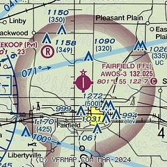
| Sectional chart |
|---|
|
| Airport distance calculator |
|---|
|
|
| Sunrise and sunset |
|---|
|
Times for 23-May-2026
| | Local
(UTC-5) | | Zulu
(UTC) |
|---|
| Morning civil twilight | | 05:12 | | 10:12 |
| Sunrise | | 05:44 | | 10:44 |
| Sunset | | 20:25 | | 01:25 |
| Evening civil twilight | | 20:57 | | 01:57 |
|
| Current date and time |
|---|
| Zulu (UTC) | 23-May-2026 14:02:43 |
|---|
| Local (UTC-5) | 23-May-2026 09:02:43 |
|---|
|
| METAR |
|---|
| KFFL | 231355Z AUTO 21004KT 10SM BKN036 19/16 A2998 RMK A01
|
KAWG
19nm NE | 231355Z AUTO 21006KT OVC029 19/15 A2997 RMK AO2
|
|
| TAF |
|---|
KOTM
21nm W | 231130Z 2312/2412 VRB03KT P6SM SCT030 FM231300 25006KT P6SM BKN018 PROB30 2313/2314 6SM -SHRA BKN025 FM231700 26006KT P6SM BKN026 PROB30 2317/2318 4SM -SHRA OVC026 FM231800 27007KT P6SM SCT060 FM240200 VRB05KT P6SM FEW250
|
|
| NOTAMs |
|---|
NOTAMs are issued by the DoD/FAA and will open in a separate window not controlled by AirNav.
|
|

