FAA INFORMATION EFFECTIVE 14 MAY 2026
Location
| FAA Identifier: | OTM |
| Lat/Long: | 41-06-26.0000N 092-26-49.8000W
41-06.433333N 092-26.830000W
41.1072222,-92.4471667
(estimated) |
| Elevation: | 845.6 ft. / 257.7 m (surveyed) |
| Variation: | 01W (2025) |
| From city: | 5 miles NW of OTTUMWA, IA |
| Time zone: | UTC -5 (UTC -6 during Standard Time) |
| Zip code: | 52501 |
Airport Operations
| Airport use: | Open to the public |
| Activation date: | 04/1944 |
| Control tower: | no |
| ARTCC: | CHICAGO CENTER |
| FSS: | FORT DODGE FLIGHT SERVICE STATION |
| NOTAMs facility: | OTM (NOTAM-D service available) |
| Attendance: | 0700-2000
FOR ATTENDANT AFT HRS CALL 641-799-9120 OR 641-208-5821. |
| Wind indicator: | lighted |
| Segmented circle: | no |
| Lights: | ACTVT MALSR RWY 31; REIL RWY 04, 22 & 13; PAPI RWY 04, 13 & 22; HIRL RWY 13/31 & RWY 04/22 - CTAF. |
| Beacon: | white-green (lighted land airport)
Operates sunset to sunrise. |
Airport Communications
| CTAF/UNICOM: | 123.0 |
| WX ASOS: | 124.175 (641-684-9164) |
| WX AWOS-3 at OOA (7 nm N): | 118.625 (641-933-4312) |
- APCH/DEP SVC PRVDD BY CHICAGO ARTCC ON FREQS 118.15/335.575 (OTTUMWA RCAG).
Airport Services
| Fuel available: | 100LL JET-A |
| Parking: | hangars and tiedowns |
| Airframe service: | MAJOR |
| Powerplant service: | MAJOR |
| Bottled oxygen: | NONE |
| Bulk oxygen: | HIGH/LOW
OXYGEN AVBL DALGT HRS ONLY. |
Runway Information
Runway 13/31
| Dimensions: | 6001 x 100 ft. / 1829 x 30 m |
| Surface: | concrete/grooved, in excellent condition |
| Weight bearing capacity: | | PCN 33 /R/D/W/U | | Single wheel: | 80.0 | | Double wheel: | 105.0 | | Double tandem: | 175.0 |
|
| Runway edge lights: | high intensity |
| RUNWAY 13 | | RUNWAY 31 |
| Latitude: | 41-06.670502N | | 41-05.972110N |
| Longitude: | 092-27.366793W | | 092-26.442537W |
| Elevation: | 840.0 ft. | | 838.4 ft. |
| Traffic pattern: | left | | left |
| Runway heading: | 136 magnetic, 135 true | | 316 magnetic, 315 true |
| Markings: | precision, in good condition | | precision, in good condition |
| Visual slope indicator: | 4-light PAPI on left (3.00 degrees glide path) | | |
| Approach lights: | | | MALSR: 1,400 foot medium intensity approach lighting system with runway alignment indicator lights |
| Runway end identifier lights: | yes | | no |
| Touchdown point: | yes, no lights | | yes, no lights |
| Instrument approach: | | | ILS/DME |
Runway 4/22
| Dimensions: | 4601 x 100 ft. / 1402 x 30 m |
| Surface: | asphalt/concrete, in good condition |
| Weight bearing capacity: | | PCN 13 /F/D/X/U | | Single wheel: | 42.0 | | Double wheel: | 65.0 | | Double tandem: | 120.0 |
|
| Runway edge lights: | high intensity |
| RUNWAY 4 | | RUNWAY 22 |
| Latitude: | 41-06.311808N | | 41-06.847653N |
| Longitude: | 092-27.086697W | | 092-26.378678W |
| Elevation: | 841.4 ft. | | 832.7 ft. |
| Traffic pattern: | left | | left |
| Runway heading: | 046 magnetic, 045 true | | 226 magnetic, 225 true |
| Markings: | nonprecision, in good condition | | nonprecision, in good condition |
| Visual slope indicator: | 2-light PAPI on left (3.00 degrees glide path) | | 2-light PAPI on left (3.00 degrees glide path) |
| Runway end identifier lights: | yes | | yes |
| Touchdown point: | yes, no lights | | yes, no lights |
Airport Ownership and Management from official FAA records
| Ownership: | Publicly-owned |
| Owner: | CITY OF OTTUMWA
CITY HALL
OTTUMWA, IA 52501
Phone 641-683-0619 |
| Manager: | JAY WHEATON
14802 TERMINAL ST
OTTUMWA, IA 52501
Phone 641-683-0619 |
Additional Remarks
| - | RY 31 IS PREFERRED CALM WIND RY. |
| - | REMOTE CTL ACFT OPNS IN AREA. |
| - | FOR CD IF UNA TO CTC ON FSS FREQ, CTC CHICAGO ARTCC AT 630-906-8921. |
Instrument Procedures
NOTE: All procedures below are presented as PDF files. If you need a reader for these files, you should download the free Adobe Reader.NOT FOR NAVIGATION. Please procure official charts for flight.
FAA instrument procedures published for use from 14 May 2026 at 0901Z to 11 June 2026 at 0900Z.
IAPs - Instrument Approach Procedures |
|---|
| ILS OR LOC RWY 31 | |
download (201KB) |
| RNAV (GPS) RWY 13 | |
download (194KB) |
| RNAV (GPS) RWY 31 | |
download (211KB) |
| NOTE: Special Alternate Minimums apply | |
download (146KB) |
| NOTE: Special Take-Off Minimums/Departure Procedures apply | |
download (432KB) |
Other nearby airports with instrument procedures:
KOOA - Oskaloosa Municipal Airport (7 nm N)
4C8 - Albia Municipal Airport (16 nm SW)
KFFL - Fairfield Municipal Airport (21 nm E)
4K6 - Bloomfield Municipal Airport (23 nm S)
KPEA - Pella Municipal Airport (29 nm NW)
|
|

Road maps at:
MapQuest
Bing
Google
| Aerial photo |
|---|
WARNING: Photo may not be current or correct

Do you have a better or more recent aerial photo of Ottumwa Regional Airport that you would like to share? If so, please send us your photo.
|
| Sectional chart |
|---|
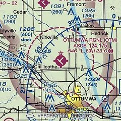
|
 Download PDF
of official airport diagram from the FAA
| Airport distance calculator |
|---|
|
|
| Sunrise and sunset |
|---|
|
Times for 24-May-2026
| | Local
(UTC-5) | | Zulu
(UTC) |
|---|
| Morning civil twilight | | 05:13 | | 10:13 |
| Sunrise | | 05:45 | | 10:45 |
| Sunset | | 20:28 | | 01:28 |
| Evening civil twilight | | 21:00 | | 02:00 |
|
| Current date and time |
|---|
| Zulu (UTC) | 25-May-2026 01:51:41 |
|---|
| Local (UTC-5) | 24-May-2026 20:51:41 |
|---|
|
| METAR |
|---|
| KOTM | 250053Z AUTO 18005KT 10SM CLR 24/12 A3001 RMK AO2 SLP159 T02390122
|
KOOA
7nm N | 250135Z AUTO 18007KT 10SM CLR 23/12 A3002 RMK AO2 T02300120
|
|
| TAF |
|---|
| KOTM | 241733Z 2418/2518 VRB03KT P6SM SKC FM242000 23009KT P6SM SKC FM242300 19007KT P6SM FEW120
|
|
| NOTAMs |
|---|
NOTAMs are issued by the DoD/FAA and will open in a separate window not controlled by AirNav.
|
|


