FAA INFORMATION EFFECTIVE 14 MAY 2026
Location
| FAA Identifier: | GZH |
| Lat/Long: | 31-24-54.0000N 087-02-36.1000W
31-24.900000N 087-02.601667W
31.4150000,-87.0433611
(estimated) |
| Elevation: | 259 ft. / 78.9 m (surveyed) |
| Variation: | 03W (2015) |
| From city: | 5 miles W of EVERGREEN, AL |
| Time zone: | UTC -5 (UTC -6 during Standard Time) |
| Zip code: | 36401 |
Airport Operations
| Airport use: | Open to the public |
| Activation date: | 08/1945 |
| Control tower: | no |
| ARTCC: | JACKSONVILLE CENTER |
| FSS: | ANNISTON FLIGHT SERVICE STATION |
| NOTAMs facility: | GZH (NOTAM-D service available) |
| Attendance: | MON-FRI 0800-1700 |
| Wind indicator: | yes |
| Segmented circle: | no |
| Lights: | ACTVT PAPI RWY 10; MIRL RWYS 01/19 & 10/28 - CTAF. |
| Beacon: | white-green (lighted land airport)
Operates sunset to sunrise. |
| Landing fee: | yes |
Airport Communications
| CTAF/UNICOM: | 122.7 |
| WX ASOS: | 133.425 (251-578-1438) |
- APCH/DEP SVC PRVDD BY JACKSONVILLE ARTCC ON FREQS 134.15/338.3 (CRESTVIEW RCAG).
Nearby radio navigation aids
| VOR radial/distance | | VOR name | | Freq | | Var |
|---|
| MVCr096/16.0 | | MONROEVILLE VORTAC | | 116.80 | | 04E |
| CEWr329/40.0 | | CRESTVIEW VORTAC | | 115.90 | | 03E |
Airport Services
| Fuel available: | 100LL JET-A+ |
| Parking: | hangars and tiedowns |
| Bottled oxygen: | NONE |
| Bulk oxygen: | NONE |
Runway Information
Runway 1/19
| Dimensions: | 5005 x 150 ft. / 1526 x 46 m |
| Surface: | asphalt, in good condition |
| Runway edge lights: | medium intensity |
| Runway edge markings: | MARKINGS FADED. |
| RUNWAY 1 | | RUNWAY 19 |
| Latitude: | 31-24.391348N | | 31-25.213648N |
| Longitude: | 087-02.866167W | | 087-02.776508W |
| Elevation: | 251.7 ft. | | 257.8 ft. |
| Traffic pattern: | left | | left |
| Runway heading: | 008 magnetic, 005 true | | 188 magnetic, 185 true |
| Markings: | nonprecision, in fair condition | | nonprecision, in fair condition |
| Touchdown point: | yes, no lights | | yes, no lights |
| Obstructions: | 41 ft. tree, 1054 ft. from runway, 368 ft. left of centerline, 20:1 slope to clear | | 77 ft. tree, 1323 ft. from runway, 402 ft. left of centerline, 14:1 slope to clear |
Runway 10/28
| Dimensions: | 5004 x 150 ft. / 1525 x 46 m |
| Surface: | asphalt, in good condition |
| Weight bearing capacity: | | Single wheel: | 30.0 | | Double wheel: | 50.0 |
|
| Runway edge lights: | medium intensity |
| Runway edge markings: | MARKINGS FADED. |
| RUNWAY 10 | | RUNWAY 28 |
| Latitude: | 31-25.065077N | | 31-24.928672N |
| Longitude: | 087-02.855833W | | 087-01.906662W |
| Elevation: | 258.9 ft. | | 248.8 ft. |
| Traffic pattern: | left | | left |
| Runway heading: | 103 magnetic, 100 true | | 283 magnetic, 280 true |
| Markings: | nonprecision, in fair condition | | nonprecision, in fair condition |
| Visual slope indicator: | 4-light PAPI on left (3.00 degrees glide path) | | |
| Touchdown point: | yes, no lights | | yes, no lights |
| Obstructions: | 45 ft. tree, 1095 ft. from runway, 116 ft. left of centerline, 19:1 slope to clear | | 62 ft. tree, 1438 ft. from runway, 181 ft. left of centerline, 19:1 slope to clear |
Airport Ownership and Management from official FAA records
| Ownership: | Publicly-owned |
| Owner: | CITY OF EVERGREEN
355 EAST FRONT ST PO BOX 229
EVERGREEN, AL 36401
Phone 251-578-1574 |
| Manager: | BRIAN MARTIN
14134 US HWY 84 WEST
EVERGREEN, AL 36401
Phone 251-369-2448 |
Additional Remarks
| - | INTENSIVE NAVY PROP TRNG MON-FRI SR-SS. |
| - | DIST MKRS ON BOTH SIDES OF RWYS 10/28 & 01/19 ARE US NAVY EQUIP. |
| - | MILITARY: MISC: TRAILER MANNED BY USN RWY DUTY OFFICER WHEN A110-01 ACTIVE. PERM USN CRASH CREW. |
| - | FOR CD CTC JACKSONVILLE ARTCC AT 904-845-1592. |
| - | FOR AFT HRS SVC CALL 251-369-2091. |
| - | MILITARY: MISC: OPR 1400-2300Z++ MON-FRI. (MIL OPR 1245-2230Z++ MON-FRI; 1430-2300Z++ SAT. |
Instrument Procedures
NOTE: All procedures below are presented as PDF files. If you need a reader for these files, you should download the free Adobe Reader.NOT FOR NAVIGATION. Please procure official charts for flight.
FAA instrument procedures published for use from 14 May 2026 at 0901Z to 11 June 2026 at 0900Z.
IAPs - Instrument Approach Procedures |
|---|
| RNAV (GPS) RWY 01 | |
download (189KB) |
| RNAV (GPS) RWY 10 | |
download (219KB) |
| RNAV (GPS) RWY 19 | |
download (213KB) |
| RNAV (GPS) RWY 28 | |
download (197KB) |
| NOTE: Special Alternate Minimums apply | |
download (160KB) |
| NOTE: Special Take-Off Minimums/Departure Procedures apply | |
download (524KB) |
Other nearby airports with instrument procedures:
KMVC - Monroe County Aeroplex Airport (16 nm W)
12J - Brewton Municipal Airport (22 nm S)
0R1 - Atmore Municipal Airport (32 nm SW)
79J - South Alabama Regional Airport at Bill Benton Field (34 nm E)
KPRN - Mac Crenshaw Memorial Airport (34 nm NE)
|
|

Road maps at:
MapQuest
Bing
Google
| Aerial photo |
|---|
WARNING: Photo may not be current or correct
 Photo taken 11-Feb-2011
looking north.
Photo taken 11-Feb-2011
looking north.
Do you have a better or more recent aerial photo of Evergreen Regional Airport/Middleton Field that you would like to share? If so, please send us your photo.
|
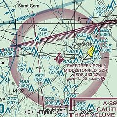
| Sectional chart |
|---|
|
| Airport distance calculator |
|---|
|
|
| Sunrise and sunset |
|---|
|
Times for 20-May-2026
| | Local
(UTC-5) | | Zulu
(UTC) |
|---|
| Morning civil twilight | | 05:23 | | 10:23 |
| Sunrise | | 05:50 | | 10:50 |
| Sunset | | 19:39 | | 00:39 |
| Evening civil twilight | | 20:06 | | 01:06 |
|
| Current date and time |
|---|
| Zulu (UTC) | 20-May-2026 05:05:58 |
|---|
| Local (UTC-5) | 20-May-2026 00:05:58 |
|---|
|
| METAR |
|---|
| KGZH | 200453Z AUTO 00000KT 10SM CLR 22/21 A3011 RMK AO2 SLP191 T02170206
|
|
| TAF |
|---|
KNSE
42nm S | 192300Z 1923/2023 19008KT 9999 SCT040 SCT250 QNH3006INS BECMG 2004/2006 17006KT 8000 BR SCT005 BKN250 QNH3007INS TEMPO 2007/2013 1600 BR OVC004 FM201400 15007KT 9999 VCSH SCT015 SCT200 QNH3009INS FM201700 18012G18KT 9999 VCSH SCT045CB SCT100 BKN200 QNH3000INS FM202200 20010KT 9999 SCT050 SCT250 QNH2998INS AUTOMATED SENSOR METWATCH 2004 TIL 2011 TX31/2019Z TN21/2009Z FN20029
|
|
| NOTAMs |
|---|
NOTAMs are issued by the DoD/FAA and will open in a separate window not controlled by AirNav.
|
|

