FAA INFORMATION EFFECTIVE 14 MAY 2026
Location
| FAA Identifier: | IJX |
| Lat/Long: | 39-46-28.6000N 090-14-17.8000W
39-46.476667N 090-14.296667W
39.7746111,-90.2382778
(estimated) |
| Elevation: | 623.9 ft. / 190.2 m (surveyed) |
| Variation: | 03E (1980) |
| From city: | 3 miles N of JACKSONVILLE, IL |
| Time zone: | UTC -5 (UTC -6 during Standard Time) |
| Zip code: | 62650 |
Airport Operations
| Airport use: | Open to the public |
| Activation date: | 07/1950 |
| Control tower: | no |
| ARTCC: | KANSAS CITY CENTER |
| FSS: | SAINT LOUIS FLIGHT SERVICE STATION |
| NOTAMs facility: | IJX (NOTAM-D service available) |
| Attendance: | 0700-DUSK |
| Wind indicator: | lighted |
| Segmented circle: | no |
| Lights: | ACTVT MIRL RY 13/31, 04/22, REIL RYS 22, 13 & 31, & TWY LGTS - CTAF. |
| Beacon: | white-green (lighted land airport)
Operates sunset to sunrise. |
Airport Communications
| CTAF/UNICOM: | 122.8 |
| WX AWOS-3PT: | 120.525 (217-243-6379) |
| SAINT LOUIS APPROACH: | 126.15 |
| SAINT LOUIS DEPARTURE: | 126.15 |
| CLEARANCE DELIVERY: | 118.45 |
Nearby radio navigation aids
| VOR radial/distance | | VOR name | | Freq | | Var |
|---|
| SPIr262/26.1 | | SPINNER VORTAC | | 112.70 | | 01W |
Airport Services
| Fuel available: | 100LL JET-A |
| Parking: | hangars and tiedowns |
| Airframe service: | MAJOR |
| Powerplant service: | MAJOR |
| Bottled oxygen: | NONE |
| Bulk oxygen: | NONE |
Runway Information
Runway 13/31
| Dimensions: | 5000 x 75 ft. / 1524 x 23 m |
| Surface: | asphalt, in good condition |
| Weight bearing capacity: | | Single wheel: | 22.0 | | Double wheel: | 28.0 |
|
| Runway edge lights: | medium intensity |
| RUNWAY 13 | | RUNWAY 31 |
| Latitude: | 39-46.759463N | | 39-46.175672N |
| Longitude: | 090-14.683270W | | 090-13.930680W |
| Elevation: | 616.6 ft. | | 621.0 ft. |
| Traffic pattern: | left | | left |
| Runway heading: | 132 magnetic, 135 true | | 312 magnetic, 315 true |
| Markings: | nonprecision, in fair condition | | nonprecision, in fair condition |
| Visual slope indicator: | 4-box VASI on left (3.00 degrees glide path) | | |
| Runway end identifier lights: | yes | | yes |
| Touchdown point: | yes, no lights | | yes, no lights |
Runway 4/22
| Dimensions: | 4001 x 75 ft. / 1220 x 23 m |
| Surface: | asphalt, in good condition |
| Runway edge lights: | medium intensity |
| RUNWAY 4 | | RUNWAY 22 |
| Latitude: | 39-46.254518N | | 39-46.720515N |
| Longitude: | 090-14.584780W | | 090-13.980903W |
| Elevation: | 617.1 ft. | | 618.2 ft. |
| Traffic pattern: | left | | left |
| Runway heading: | 042 magnetic, 045 true | | 222 magnetic, 225 true |
| Markings: | basic, in fair condition | | basic, in fair condition |
| Runway end identifier lights: | no | | yes |
| Touchdown point: | yes, no lights | | yes, no lights |
Airport Ownership and Management from official FAA records
| Ownership: | Publicly-owned |
| Owner: | JACKSONVILLE AIRPORT AUTH
1956 BALDWIN RD
JACKSONVILLE, IL 62650
Phone 217-243-5824 |
| Manager: | SHASTIN SAXER
1956 BALDWIN RD, JACKSONVILLE AIRPORT
JACKSONVILLE, IL 62650
Phone 217-243-5824
EMAIL ADDRESS: MANAGER@FLYIJX.COM. (ALL LOWER CASE) |
Additional Remarks
| - | DEER ON & INVOF OF ARPT. |
| - | FOR CD CTC ST LOUIS APCH 314-890-1017. |
Instrument Procedures
NOTE: All procedures below are presented as PDF files. If you need a reader for these files, you should download the free Adobe Reader.NOT FOR NAVIGATION. Please procure official charts for flight.
FAA instrument procedures published for use from 14 May 2026 at 0901Z to 11 June 2026 at 0900Z.
IAPs - Instrument Approach Procedures |
|---|
| RNAV (GPS) RWY 04 | |
download (190KB) |
| RNAV (GPS) RWY 13 | |
download (180KB) |
| RNAV (GPS) RWY 22 | |
download (194KB) |
| RNAV (GPS) RWY 31 | |
download (186KB) |
| NOTE: Special Alternate Minimums apply | |
download (61KB) |
| NOTE: Special Take-Off Minimums/Departure Procedures apply | |
download (513KB) |
Other nearby airports with instrument procedures:
KSPI - Abraham Lincoln Capital Airport (26 nm E)
KPPQ - Pittsfield Penstone Municipal Airport (26 nm W)
I63 - Mount Sterling Municipal Airport (29 nm NW)
KTAZ - Taylorville Municipal Airport (44 nm E)
3LF - Litchfield Municipal Airport (45 nm SE)
|
|

Road maps at:
MapQuest
Bing
Google
| Aerial photo |
|---|
WARNING: Photo may not be current or correct

Do you have a better or more recent aerial photo of Jacksonville Municipal Airport that you would like to share? If so, please send us your photo.
|
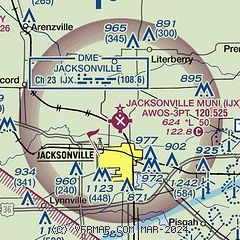
| Sectional chart |
|---|
|
| Airport distance calculator |
|---|
|
|
| Sunrise and sunset |
|---|
|
Times for 02-Jun-2026
| | Local
(UTC-5) | | Zulu
(UTC) |
|---|
| Morning civil twilight | | 05:03 | | 10:03 |
| Sunrise | | 05:35 | | 10:35 |
| Sunset | | 20:22 | | 01:22 |
| Evening civil twilight | | 20:54 | | 01:54 |
|
| Current date and time |
|---|
| Zulu (UTC) | 02-Jun-2026 21:15:31 |
|---|
| Local (UTC-5) | 02-Jun-2026 16:15:31 |
|---|
|
| METAR |
|---|
| KIJX | 022055Z AUTO 09010G15KT 10SM CLR 28/08 A3025 RMK AO2 T02820076
|
|
| TAF |
|---|
KSPI
26nm E | 021720Z 0218/0318 09011KT P6SM FEW250 FM030000 10006KT P6SM SCT250
|
|
| NOTAMs |
|---|
NOTAMs are issued by the DoD/FAA and will open in a separate window not controlled by AirNav.
|
|

