FAA INFORMATION EFFECTIVE 14 MAY 2026
Location
| FAA Identifier: | INF |
| Lat/Long: | 28-48-13.0060N 082-19-05.8470W
28-48.216767N 082-19.097450W
28.8036128,-82.3182908
(estimated) |
| Elevation: | 64.5 ft. / 19.7 m (surveyed) |
| Variation: | 05W (2010) |
| From city: | 2 miles SE of INVERNESS, FL |
| Time zone: | UTC -4 (UTC -5 during Standard Time) |
| Zip code: | 34436 |
Airport Operations
| Airport use: | Open to the public |
| Activation date: | 01/1946 |
| Control tower: | no |
| ARTCC: | JACKSONVILLE CENTER |
| FSS: | SAINT PETERSBURG FLIGHT SERVICE STATION |
| NOTAMs facility: | PIE (NOTAM-D service available) |
| Attendance: | 0600-2000 |
| Wind indicator: | lighted |
| Segmented circle: | yes |
| Lights: | ACTVT REIL RWY 01 & 19; MIRL RWY 01/19 - CTAF. |
| Beacon: | white-green (lighted land airport)
Operates sunset to sunrise. |
Airport Communications
| CTAF/UNICOM: | 122.725 |
| WX AWOS-3: | 119.975 (352-560-6012) |
| JACKSONVILLE APPROACH: | 118.6 [0700-2300] |
| JACKSONVILLE DEPARTURE: | 118.6 [0700-2300] |
| WX AWOS-3 at CGC (14 nm W): | 118.325 (352-563-6600) |
Nearby radio navigation aids
| VOR radial/distance | | VOR name | | Freq | | Var |
|---|
| OCFr192/22.9 | | OCALA VORTAC | | 113.70 | | 00E |
Airport Services
| Fuel available: | 100LL JET-A+
100LL:FUEL 24 HR CREDIT CARD SVC AVBL. |
| Parking: | tiedowns |
| Airframe service: | MAJOR |
| Powerplant service: | MAJOR |
| Bottled oxygen: | NONE |
| Bulk oxygen: | NONE |
Runway Information
Runway 1/19
| Dimensions: | 5000 x 75 ft. / 1524 x 23 m |
| Surface: | asphalt/grooved, in good condition |
| Weight bearing capacity: | | PCN 16 /F/A/X/T | | Single wheel: | 53.0 | | Double wheel: | 75.0 |
|
| Runway edge lights: | medium intensity |
| RUNWAY 1 | | RUNWAY 19 |
| Latitude: | 28-47.806592N | | 28-48.626948N |
| Longitude: | 082-19.147542W | | 082-19.047355W |
| Elevation: | 64.4 ft. | | 40.2 ft. |
| Traffic pattern: | right | | left |
| Runway heading: | 011 magnetic, 006 true | | 191 magnetic, 186 true |
| Markings: | nonprecision, in good condition | | nonprecision, in good condition |
| Visual slope indicator: | 4-light PAPI on left (3.50 degrees glide path) | | 4-light PAPI on left (3.50 degrees glide path) |
| Runway end identifier lights: | yes | | yes |
| Touchdown point: | yes, no lights | | yes, no lights |
| Obstructions: | 43 ft. tree, 900 ft. from runway, 200 ft. left of centerline, 16:1 slope to clear | | 98 ft. trees, 1665 ft. from runway, 315 ft. right of centerline, 14:1 slope to clear |
Airport Ownership and Management from official FAA records
| Ownership: | Publicly-owned |
| Owner: | CITRUS COUNTY
110 NORTH APOPKA AVE
INVERNESS, FL 34450
Phone 352-527-5478 |
| Manager: | TODD REGAN
3600 W SOVEREIGN PATH, SUITE 210
INVERNESS, FL 34450
Phone 352-527-5488 |
Additional Remarks
| - | RWY 19 300' AGL TOWER 5600' N OF THR 2500' R OF CL. |
| - | FOR CD CTC JACKSONVILLE APCH AT 904-741-0284. |
| - | UNLGTD OBSTNS IN RWY 01 APCH, TREES 89 FT TALL, 2140 FT FM AER RWY 01. |
| - | UNLGTD OBSTNS IN RWY 19 APPCH, TREES 98 FT TALL, 1,655 FT FM AER RWY 19. |
Instrument Procedures
NOTE: All procedures below are presented as PDF files. If you need a reader for these files, you should download the free Adobe Reader.NOT FOR NAVIGATION. Please procure official charts for flight.
FAA instrument procedures published for use from 14 May 2026 at 0901Z to 11 June 2026 at 0900Z.
IAPs - Instrument Approach Procedures |
|---|
| RNAV (GPS) RWY 01 | |
download (195KB) |
| RNAV (GPS) RWY 19 | |
download (173KB) |
| NOTE: Special Alternate Minimums apply | |
download (22KB) |
| NOTE: Special Take-Off Minimums/Departure Procedures apply | |
download (162KB) |
Other nearby airports with instrument procedures:
KCGC - Crystal River Airport/Davis Field (14 nm W)
X35 - Marion County Airport (16 nm N)
KBKV - Brooksville-Tampa Bay Regional Airport (21 nm S)
KOCF - Ocala International Airport-Jim Taylor Field (23 nm N)
KLEE - Leesburg International Airport (27 nm E)
|
|

Road maps at:
MapQuest
Bing
Google
| Aerial photo |
|---|
WARNING: Photo may not be current or correct
 Photo by Banning Sherman
Photo taken 08-Sep-2019
looking south.
Photo by Banning Sherman
Photo taken 08-Sep-2019
looking south.
Do you have a better or more recent aerial photo of Inverness Airport that you would like to share? If so, please send us your photo.
|
| Sectional chart |
|---|
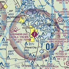
|
| Airport distance calculator |
|---|
|
|
| Sunrise and sunset |
|---|
|
Times for 01-Jun-2026
| | Local
(UTC-4) | | Zulu
(UTC) |
|---|
| Morning civil twilight | | 06:06 | | 10:06 |
| Sunrise | | 06:32 | | 10:32 |
| Sunset | | 20:22 | | 00:22 |
| Evening civil twilight | | 20:48 | | 00:48 |
|
| Current date and time |
|---|
| Zulu (UTC) | 01-Jun-2026 10:56:08 |
|---|
| Local (UTC-4) | 01-Jun-2026 06:56:08 |
|---|
|
| METAR |
|---|
| KINF | 011035Z AUTO 00000KT 5SM BR CLR 25/25 A2996 RMK AO2
|
KCGC
14nm W | 011035Z AUTO 26008G14KT 10SM SCT021 SCT028 SCT041 27/24 A2996 RMK AO2
|
|
| TAF |
|---|
KLEE
26nm E | 010533Z 0106/0206 VRB04KT P6SM SKC FM011400 30011KT P6SM VCSH SCT035 SCT080 BKN100 FM012000 29010KT P6SM SCT120 FM020200 26004KT P6SM SCT060 BKN250
|
|
| NOTAMs |
|---|
NOTAMs are issued by the DoD/FAA and will open in a separate window not controlled by AirNav.
|
|


