FAA INFORMATION EFFECTIVE 14 MAY 2026
Location
| FAA Identifier: | LEE |
| Lat/Long: | 28-49-22.4330N 081-48-30.3030W
28-49.373883N 081-48.505050W
28.8228981,-81.8084175
(estimated) |
| Elevation: | 76 ft. / 23.2 m (surveyed) |
| Variation: | 05W (2010) |
| From city: | 3 miles NE of LEESBURG, FL |
| Time zone: | UTC -4 (UTC -5 during Standard Time) |
| Zip code: | 34748 |
Airport Operations
| Airport use: | Open to the public |
| Activation date: | 01/1943 |
| Control tower: | yes |
| ARTCC: | JACKSONVILLE CENTER |
| FSS: | SAINT PETERSBURG FLIGHT SERVICE STATION |
| NOTAMs facility: | LEE (NOTAM-D service available) |
| Attendance: | 0700-1900 |
| Wind indicator: | lighted |
| Segmented circle: | yes |
| Lights: | ACTVT REILS 13 & 31; PAPI RWYS 04, 22, 13 & 31; MIRL RWYS 04/22 & 13/31 - CTAF. TWY LGTS OPR DUSK - 2200; AFT 2200 ACTVT - CTAF. |
| Beacon: | white-green (lighted land airport)
Operates sunset to sunrise. |
| International operations: | US CUSTOMS USER FEE ARPT. |
Airport Communications
| CTAF: | 119.35 |
| UNICOM: | 122.725 |
| ATIS: | 134.325 |
| WX ASOS: | PHONE 352-787-1565 |
| LEESBURG GROUND: | 121.725 [0700-1900] |
| LEESBURG TOWER: | 119.35 [0700-1900] |
| ORLANDO APPROACH: | 120.225 135.3 |
| ORLANDO DEPARTURE: | 120.225 135.3 |
| CLEARANCE DELIVERY: | 120.225 ;WHEN TWR CLSD |
| ALYNA STAR: | 124.8 |
| IC: | 135.3 |
| JOKRS STAR: | 134.05 |
| MINEE STAR: | 134.05 |
| MUNGI STAR: | 128.375 |
| PRICY STAR: | 134.05 |
| TTHOR STAR: | 118.85 125.225 |
Nearby radio navigation aids
| VOR radial/distance | | VOR name | | Freq | | Var |
|---|
| ORLr304/30.1 | | ORLANDO VORTAC | | 112.20 | | 00E |
| OCFr134/30.6 | | OCALA VORTAC | | 113.70 | | 00E |
Airport Services
| Fuel available: | 100LL JET-A
100LL:24 HR SELF SERVE. |
| Parking: | hangars and tiedowns |
| Airframe service: | MAJOR |
| Powerplant service: | MAJOR |
| Bottled oxygen: | LOW |
| Bulk oxygen: | NONE |
Runway Information
Runway 13/31
| Dimensions: | 6300 x 100 ft. / 1920 x 30 m |
| Surface: | asphalt/grooved, in good condition |
| Weight bearing capacity: | | PCN 17 /F/B/Y/T | | Double wheel: | 60.0 |
|
| Runway edge lights: | medium intensity |
| Operational restrictions: | 25 FT PAVED SHOULDERS EACH SIDE. TREES ALG SW SIDE OF RWY IN TRSN SFC. |
| RUNWAY 13 | | RUNWAY 31 |
| Latitude: | 28-49.761120N | | 28-49.095703N |
| Longitude: | 081-49.008717W | | 081-48.101953W |
| Elevation: | 72.1 ft. | | 66.3 ft. |
| Traffic pattern: | left | | left |
| Runway heading: | 135 magnetic, 130 true | | 315 magnetic, 310 true |
| Displaced threshold: | 290 ft. | | 400 ft. |
| Declared distances: | TORA:6300 TODA:6300 ASDA:5500 LDA:5211 | | TORA:6300 TODA:6300 ASDA:6000 LDA:5600 |
| Markings: | nonprecision, in good condition | | nonprecision, in good condition |
| Visual slope indicator: | 4-light PAPI on left (3.00 degrees glide path) | | 4-light PAPI on left (3.00 degrees glide path) |
| Runway end identifier lights: | yes | | yes |
| Touchdown point: | yes, no lights | | yes, no lights |
| Obstructions: | 64 ft. trees, 1870 ft. from runway, 250 ft. left of centerline, 26:1 slope to clear
APCH SLP 34:1 TO DTHR. | | 5 ft. brush, 200 ft. from runway, 170 ft. left of centerline
BRUSH 5 FT TALL 200 FT BEFORE TO 920 FT AFTER AER INSIDE PRI SFC. |
Runway 4/22
| Dimensions: | 4957 x 100 ft. / 1511 x 30 m |
| Surface: | asphalt, in good condition |
| Weight bearing capacity: | | PCN 14 /F/B/Y/T | | Single wheel: | 21.0 |
|
| Runway edge lights: | medium intensity |
| RUNWAY 4 | | RUNWAY 22 |
| Latitude: | 28-48.969548N | | 28-49.639602N |
| Longitude: | 081-48.707430W | | 081-48.174872W |
| Elevation: | 66.7 ft. | | 75.2 ft. |
| Traffic pattern: | left | | left |
| Runway heading: | 040 magnetic, 035 true | | 220 magnetic, 215 true |
| Displaced threshold: | no | | 310 ft. |
| Declared distances: | TORA:4957 TODA:4957 ASDA:4688 LDA:4688 | | TORA:4957 TODA:4957 ASDA:4957 LDA:4647 |
| Markings: | nonprecision, in good condition | | basic, in good condition |
| Visual slope indicator: | 4-light PAPI on left (3.00 degrees glide path) | | 4-light PAPI on right (3.00 degrees glide path) |
| Touchdown point: | yes, no lights | | yes, no lights |
| Obstructions: | 9 ft. brush, 200 ft. from runway, 80 ft. left of centerline
25 FT TREES 235 FT LEFT OF CNTRLN 100 FT FM RWY END. | | 11 ft. berm, marked and lighted, 81 ft. from runway
11 FT BERM FULL WID OF RWY 81 FT FM RWY END. |
Runway 3W/21W
| Dimensions: | 15000 x 2000 ft. / 4572 x 610 m |
| Surface: | water |
| RUNWAY 3W | | RUNWAY 21W |
| Elevation: | 63.0 ft. | | 63.0 ft. |
| Traffic pattern: | left | | left |
Airport Ownership and Management from official FAA records
| Ownership: | Publicly-owned |
| Owner: | CITY OF LEESBURG
PO BOX 490630
LEESBURG, FL 34749-0630
Phone 352-516-7236 |
| Manager: | TRACEY DEAN
PO BOX 490630
LEESBURG, FL 34749
Phone 352-728-9801
EXT 1130 OR 352-728-9786. |
Additional Remarks
| A30A-04 | TREES 235 FT W OF CNTRLN FOR FIRST 1000 FT INSIDE PRI SFC. |
| - | BIRD ACT INVOF ARPT. |
| - | UNLGTD 30 FT OBSTNS 440 FT BFR AER RWY 04. |
| - | 24 HR PPR FOR ACFT EQUIPPED WITH WEATHER MODIFICATION OR GEOENGINEERING EQPT 352-516-7236. |
Instrument Procedures
NOTE: All procedures below are presented as PDF files. If you need a reader for these files, you should download the free Adobe Reader.NOT FOR NAVIGATION. Please procure official charts for flight.
FAA instrument procedures published for use from 14 May 2026 at 0901Z to 11 June 2026 at 0900Z.
STARs - Standard Terminal Arrivals |
|---|
| ALYNA FOUR (RNAV) | |
download (276KB) |
| JOKRS FOUR (RNAV) | |
2 pages:
[1] [2] (333KB) |
| MINEE SIX | |
2 pages:
[1] [2] (327KB) |
| MUNGI ONE (RNAV) | |
2 pages:
[1] [2] (503KB) |
| PRICY FIVE (RNAV) | |
2 pages:
[1] [2] (404KB) |
| PRICY FIVE (RNAV), CONT.2 | |
download (152KB) |
| SLOAO ONE (RNAV) | |
download (163KB) |
| TTHOR THREE (RNAV) | |
2 pages:
[1] [2] (335KB) |
IAPs - Instrument Approach Procedures |
|---|
| RNAV (GPS) RWY 04 **CHANGED** | |
download (220KB) |
| RNAV (GPS) RWY 13 **CHANGED** | |
download (261KB) |
| RNAV (GPS) RWY 31 **CHANGED** | |
download (275KB) |
| NOTE: Special Alternate Minimums apply | |
download (127KB) |
| NOTE: Special Take-Off Minimums/Departure Procedures apply | |
download (403KB) |
Other nearby airports with instrument procedures:
X23 - Umatilla Municipal Airport (10 nm NE)
X04 - Orlando Apopka Airport (14 nm SE)
KINF - Inverness Airport (27 nm W)
KORL - Orlando Executive Airport (30 nm SE)
KOCF - Ocala International Airport-Jim Taylor Field (30 nm NW)
|
|

Road maps at:
MapQuest
Bing
Google
| Aerial photo |
|---|
WARNING: Photo may not be current or correct
 Photo courtesy of Ashlan Air Services, LLC
Photo taken 17-Nov-2016
looking west
Photo courtesy of Ashlan Air Services, LLC
Photo taken 17-Nov-2016
looking west
Do you have a better or more recent aerial photo of Leesburg International Airport that you would like to share? If so, please send us your photo.
|
| Sectional chart |
|---|
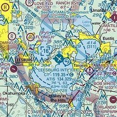
|
CAUTION: Diagram may not be current

| Airport distance calculator |
|---|
|
|
| Sunrise and sunset |
|---|
|
Times for 16-May-2026
| | Local
(UTC-4) | | Zulu
(UTC) |
|---|
| Morning civil twilight | | 06:11 | | 10:11 |
| Sunrise | | 06:36 | | 10:36 |
| Sunset | | 20:11 | | 00:11 |
| Evening civil twilight | | 20:37 | | 00:37 |
|
| Current date and time |
|---|
| Zulu (UTC) | 16-May-2026 11:29:29 |
|---|
| Local (UTC-4) | 16-May-2026 07:29:29 |
|---|
|
| METAR |
|---|
| KLEE | 161053Z 04007KT 10SM CLR 22/21 A3010 RMK AO2 SLP190 T02170206
|
|
| TAF |
|---|
| KLEE | 160520Z 1606/1706 07006KT P6SM FEW030 FEW040 FM161400 13009KT P6SM SCT050 FM162200 12009KT P6SM VCTS SCT050CB SCT300 FM170200 12006KT P6SM SCT080 SCT300
|
|
| NOTAMs |
|---|
NOTAMs are issued by the DoD/FAA and will open in a separate window not controlled by AirNav.
|
|


