FAA INFORMATION EFFECTIVE 09 JULY 2026
Location
| FAA Identifier: | CGC |
| Lat/Long: | 28-52-03.4000N 082-34-26.8000W
28-52.056667N 082-34.446667W
28.8676111,-82.5741111
(estimated) |
| Elevation: | 8.9 ft. / 2.7 m (surveyed) |
| Variation: | 05W (2010) |
| From city: | 3 miles SE of CRYSTAL RIVER, FL |
| Time zone: | UTC -4 (UTC -5 during Standard Time) |
| Zip code: | 34429 |
Airport Operations
| Airport use: | Open to the public |
| Activation date: | 04/1940 |
| Control tower: | no |
| ARTCC: | JACKSONVILLE CENTER |
| FSS: | SAINT PETERSBURG FLIGHT SERVICE STATION |
| NOTAMs facility: | CGC (NOTAM-D service available) |
| Attendance: | 0800-1800 |
| Wind indicator: | lighted |
| Segmented circle: | yes |
| Lights: | ACTVT REIL RWY 09, 27; MIRL RWY 09/27 - CTAF. |
| Beacon: | white-green (lighted land airport)
Operates sunset to sunrise. |
Airport Communications
| CTAF/UNICOM: | 122.725 |
| WX AWOS-3: | 118.325 (352-563-6600) |
| JACKSONVILLE APPROACH: | 118.6 |
| JACKSONVILLE DEPARTURE: | 118.6 |
| WX AWOS-3 at INF (14 nm E): | 119.975 (352-560-6012) |
Nearby radio navigation aids
| VOR radial/distance | | VOR name | | Freq | | Var |
|---|
| OCFr224/26.0 | | OCALA VORTAC | | 113.70 | | 00E |
Airport Services
| Fuel available: | 100LL JET-A |
| Parking: | tiedowns |
| Airframe service: | MINOR |
| Powerplant service: | MINOR |
| Bottled oxygen: | NONE |
| Bulk oxygen: | NONE |
Runway Information
Runway 9/27
| Dimensions: | 4557 x 75 ft. / 1389 x 23 m |
| Surface: | asphalt, in excellent condition |
| Weight bearing capacity: | | PCN 23 /F/A/X/T | | Single wheel: | 68.0 | | Double wheel: | 97.0 |
|
| Runway edge lights: | medium intensity |
| RUNWAY 9 | | RUNWAY 27 |
| Latitude: | 28-52.038235N | | 28-52.031545N |
| Longitude: | 082-34.705598W | | 082-33.851877W |
| Elevation: | 6.6 ft. | | 7.8 ft. |
| Traffic pattern: | left | | left |
| Runway heading: | 096 magnetic, 091 true | | 276 magnetic, 271 true |
| Markings: | nonprecision, in good condition | | nonprecision, in good condition |
| Visual slope indicator: | 4-light PAPI on left (3.00 degrees glide path) | | 2-light PAPI on right (3.00 degrees glide path) |
| Runway end identifier lights: | yes | | yes |
| Touchdown point: | yes, no lights | | yes, no lights |
| Obstructions: | 18 ft. road, 350 ft. from runway, 8:1 slope to clear
RWY 09 APRCH RATIO 22:1 TO DTHR. | | 18 ft. brush, 405 ft. from runway, 185 ft. right of centerline, 11:1 slope to clear |
Runway 18/36
| Dimensions: | 2666 x 100 ft. / 813 x 30 m |
| Surface: | turf, in fair condition
RWY 18/36 SOFT & WET AFT RAIN. |
| Runway edge markings: | 18/36 MKD WITH WHITE PIPES EVERY 200 FT. |
| RUNWAY 18 | | RUNWAY 36 |
| Latitude: | 28-52.315840N | | 28-51.875858N |
| Longitude: | 082-34.733695W | | 082-34.732702W |
| Elevation: | 6.1 ft. | | 5.7 ft. |
| Traffic pattern: | left | | left |
| Runway heading: | 185 magnetic, 180 true | | 005 magnetic, 360 true |
| Displaced threshold: | 192 ft.
18/36 DTHR MKD WITH GREEN PIPES. | | 819 ft. |
| Touchdown point: | yes, no lights | | yes, no lights |
| Obstructions: | 15 ft. bldg, 104 ft. from runway, 85 ft. right of centerline, 6:1 slope to clear
RWY 18 APCH RATIO 20:1 TO DTHR. | | 7 ft. fence, 15 ft. from runway, 2:1 slope to clear
RWY 36 APCH RATIO 22:1 TO DTHR. |
Airport Ownership and Management from official FAA records
| Ownership: | Publicly-owned |
| Owner: | CITRUS COUNTY
110 NORTH APOPKA AVE
INVERNESS, FL 34450
Phone 352-527-5477
CONTACT PERSON: TODD REGAN 3600 WEST SOVEREIGN PATH, SUITE 241, LACANTO FL, 34461 352-527-5247 FAX; 352-527-5482. |
| Manager: | TODD REGAN
3600 W SOVEREIGN PATH, STE 241
LECANTO, FL 34461
Phone 352-527-5488
AIRPORT PHYSICAL ADDRESS: 718 NORTH LINDBERGH DRIVE, CRYSTAL RIVER, FL 34429 352-795-6868 FAX: 352-795-1730 |
Additional Remarks
| - | GLIDER OPNS WITHIN 25 NM. |
| - | BLDG 30-85 FT W OF AER RWY 18 100 FT R OF CNTRLN. |
| - | AEROBATIC ACTVT ALONG N SIDE OF RWY 09/27 & 4 NM SW OF ARPT. CTC UNICOM FOR TFC INFO, AND NOTAMS OR FSS FOR SPECIFIC TIMES. |
| - | RWY 09/27 TREES SOUTH SIDE OF RWY IN PRIMARY & TRANSITION SFC. |
| - | FOR CD CTC JACKSONVILLE APCH AT 904-741-0284. |
| - | STANDING WATER INSIDE RWY SAFETY AREAS FOR ALL RWYS AFTER HVY RNFL. |
Instrument Procedures
NOTE: All procedures below are presented as PDF files. If you need a reader for these files, you should download the free Adobe Reader.NOT FOR NAVIGATION. Please procure official charts for flight.
FAA instrument procedures published for use from 09 July 2026 at 0901Z to 06 August 2026 at 0900Z.
IAPs - Instrument Approach Procedures |
|---|
| RNAV (GPS) RWY 09 | |
download (234KB) |
| RNAV (GPS) RWY 27 | |
download (233KB) |
| NOTE: Special Alternate Minimums apply | |
download (149KB) |
| NOTE: Special Take-Off Minimums/Departure Procedures apply | |
download (412KB) |
Other nearby airports with instrument procedures:
KINF - Inverness Airport (14 nm E)
X35 - Marion County Airport (16 nm NE)
KBKV - Brooksville-Tampa Bay Regional Airport (24 nm S)
KOCF - Ocala International Airport-Jim Taylor Field (26 nm NE)
X60 - Williston Regional Airport (30 nm N)
|
|

Road maps at:
MapQuest
Bing
Google
| Aerial photo |
|---|
WARNING: Photo may not be current or correct
 Photo courtesy of Buz Heuchan Aerial Photos, Inc.
Photo taken 07-Oct-2010
looking east.
Photo courtesy of Buz Heuchan Aerial Photos, Inc.
Photo taken 07-Oct-2010
looking east.
Do you have a better or more recent aerial photo of Crystal River Airport/Davis Field that you would like to share? If so, please send us your photo.
|
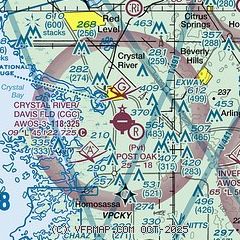
| Sectional chart |
|---|
|
| Airport distance calculator |
|---|
|
|
| Sunrise and sunset |
|---|
|
Times for 28-Jul-2026
| | Local
(UTC-4) | | Zulu
(UTC) |
|---|
| Morning civil twilight | | 06:24 | | 10:24 |
| Sunrise | | 06:50 | | 10:50 |
| Sunset | | 20:23 | | 00:23 |
| Evening civil twilight | | 20:49 | | 00:49 |
|
| Current date and time |
|---|
| Zulu (UTC) | 29-Jul-2026 02:17:48 |
|---|
| Local (UTC-4) | 28-Jul-2026 22:17:48 |
|---|
|
| METAR |
|---|
| KCGC | 290155Z AUTO 00000KT 10SM CLR 27/25 A2987 RMK AO2
|
KINF
14nm E | 290155Z AUTO 00000KT 10SM CLR 27/27 A2988 RMK AO2
|
|
| TAF |
|---|
KLEE
40nm E | 281722Z 2818/2918 23008KT P6SM VCTS SCT045CB SCT250 FM290000 23006KT P6SM SCT060 SCT250 FM291400 24010KT P6SM SCT040 SCT250
|
|
| NOTAMs |
|---|
NOTAMs are issued by the DoD/FAA and will open in a separate window not controlled by AirNav.
|
|


