FAA INFORMATION EFFECTIVE 14 MAY 2026
Location
| FAA Identifier: | IWA |
| Lat/Long: | 33-18-28.1660N 111-39-19.6530W
33-18.469433N 111-39.327550W
33.3078239,-111.6554592
(estimated) |
| Elevation: | 1384.1 ft. / 421.9 m (surveyed) |
| Variation: | 13E (1980) |
| From city: | 20 miles SE of PHOENIX, AZ |
| Time zone: | UTC -7 (year round; does not observe DST) |
| Zip code: | 85212 |
Airport Operations
| Airport use: | Open to the public |
| Activation date: | 12/1993 |
| Control tower: | yes |
| ARTCC: | ALBUQUERQUE CENTER |
| FSS: | PRESCOTT FLIGHT SERVICE STATION |
| NOTAMs facility: | IWA (NOTAM-D service available) |
| Attendance: | CONTINUOUS |
| Pattern altitude: | 2602.1 ft. MSL
TPA FIXED WING 1218 FT AGL, JET 1718 FT AGL, ROTORCRAFT 718 FT AGL. |
| Wind indicator: | yes |
| Segmented circle: | yes |
| Lights: | WHEN ATCT CLSD LGTS ON CONSLY. |
| Beacon: | white-green (lighted land airport)
Operates sunset to sunrise. |
| Landing fee: | yes, US GOV OWNED, NON REVENUE & FLT TRNG UP TO 12500 LB LNDG FEE NA. |
| Fire and rescue: | ARFF index C |
| International operations: | US CUSTOMS USER FEE ARPT. |
Airport Communications
| CTAF: | 120.6 |
| ATIS: | 133.5 270.275 |
| WX AWOS-3: | 133.5 (480-988-9428) |
| GATEWAY GROUND: | 128.25 275.8 [0500-2400] |
| GATEWAY TOWER: | 120.6 289.4 [0500-2400] |
| PHOENIX APPROACH: | 124.9 |
| PHOENIX DEPARTURE: | 124.9 |
| CLEARANCE DELIVERY: | 135.05 |
| BLYTHE STAR: | 124.1 |
| DSERT STAR: | 120.7 |
| EMERG: | 121.5 243.0 |
| HUUTY STAR: | 124.9 |
| SUNSS STAR: | 124.1 |
| WX AWOS-3PT at CHD (8 nm W): | PHONE 480-814-9952 |
| WX ASOS at FFZ (10 nm N): | PHONE 480-641-4111 |
| WX ASOS at PHX (19 nm NW): | PHONE 602-551-6092 |
- ATCT OPERATED BY SERCO MGT SERVICES.
Nearby radio navigation aids
| VOR radial/distance | | VOR name | | Freq | | Var |
|---|
| IWA at field | | WILLIE VORTAC | | 113.30 | | 13E |
| PXRr103/17.5 | | PHOENIX VORTAC | | 115.60 | | 12E |
| TFDr015/28.3 | | STANFIELD VORTAC | | 114.80 | | 12E |
Airport Services
| Fuel available: | 100LL JET-A |
| Parking: | hangars and tiedowns |
| Airframe service: | MINOR |
| Powerplant service: | MAJOR |
| Bottled oxygen: | HIGH/LOW |
Runway Information
Runway 12R/30L
| Dimensions: | 10401 x 150 ft. / 3170 x 46 m |
| Surface: | concrete, in good condition |
| Weight bearing capacity: | | Single wheel: | 55.0 | | Double wheel: | 95.0 | | Double tandem: | 185.0 | | Dual double tandem: | 550.0 |
|
| Runway edge lights: | medium intensity |
| RUNWAY 12R | | RUNWAY 30L |
| Latitude: | 33-19.060280N | | 33-17.835740N |
| Longitude: | 111-40.372085W | | 111-38.942150W |
| Elevation: | 1341.2 ft. | | 1374.2 ft. |
| Traffic pattern: | right | | left |
| Runway heading: | 123 magnetic, 136 true | | 303 magnetic, 316 true |
| Declared distances: | TORA:10401 TODA:10401 ASDA:10401 LDA:10401 | | TORA:10401 TODA:10401 ASDA:10401 LDA:10401 |
| Markings: | precision, in good condition | | precision, in good condition |
| Visual slope indicator: | 4-light PAPI on left (3.00 degrees glide path) | | 4-light PAPI on left (3.00 degrees glide path) |
| Touchdown point: | yes, no lights | | yes, no lights |
Runway 12C/30C
| Dimensions: | 10201 x 150 ft. / 3109 x 46 m |
| Surface: | asphalt/concrete, in good condition |
| Weight bearing capacity: | | Single wheel: | 55.0 | | Double wheel: | 95.0 | | Double tandem: | 185.0 | | Dual double tandem: | 550.0 |
|
| Runway edge lights: | high intensity |
| RUNWAY 12C | | RUNWAY 30C |
| Latitude: | 33-19.056775N | | 33-17.855625N |
| Longitude: | 111-39.955378W | | 111-38.553167W |
| Elevation: | 1347.7 ft. | | 1380.5 ft. |
| Traffic pattern: | left | | left |
| Runway heading: | 123 magnetic, 136 true | | 303 magnetic, 316 true |
| Declared distances: | TORA:10201 TODA:10201 ASDA:10201 LDA:10201 | | TORA:10201 TODA:10201 ASDA:10201 LDA:10201 |
| Markings: | precision, in good condition | | precision, in good condition |
| Visual slope indicator: | 4-light PAPI on left (3.00 degrees glide path) | | 4-light PAPI on left (3.00 degrees glide path) |
| Touchdown point: | yes, no lights | | yes, no lights |
| Instrument approach: | | | LOC/GS |
Runway 12L/30R
| Dimensions: | 9300 x 150 ft. / 2835 x 46 m |
| Surface: | concrete, in good condition |
| Weight bearing capacity: | | Single wheel: | 75.0 | | Double wheel: | 210.0 | | Double tandem: | 590.0 | | Dual double tandem: | 850.0 |
|
| Runway edge lights: | high intensity |
| RUNWAY 12L | | RUNWAY 30R |
| Latitude: | 33-19.055385N | | 33-17.960248N |
| Longitude: | 111-39.678765W | | 111-38.400427W |
| Elevation: | 1356.3 ft. | | 1384.1 ft. |
| Traffic pattern: | left | | right |
| Runway heading: | 123 magnetic, 136 true | | 303 magnetic, 316 true |
| Declared distances: | TORA:9300 TODA:9300 ASDA:9300 LDA:9300 | | TORA:9300 TODA:9300 ASDA:9300 LDA:9300 |
| Markings: | precision, in good condition | | precision, in good condition |
| Visual slope indicator: | 4-light PAPI on left (3.00 degrees glide path) | | 4-light PAPI on left (3.00 degrees glide path) |
| Runway end identifier lights: | yes | | yes |
| Touchdown point: | yes, no lights | | yes, no lights |
Airport Ownership and Management from official FAA records
| Ownership: | Publicly-owned |
| Owner: | MESA GATEWAY ARPT AUTH
5835 S. SOSSAMAN RD
MESA, AZ 85212-0919
Phone 480-988-7570 |
| Manager: | IVAN SMITH
5835 S. SOSSAMAN ROAD
MESA, AZ 85212-0919
Phone 480-988-7708 |
Additional Remarks
| A39-12L/30R | PCR VALUE: 858/R/C/W/T |
| A39-12R/30L | PCR VALUE: 605/R/C/W/T |
| A39-12C/30C | PCR VALUE: 692/R/D/W/T |
| A30A-30R | SPORT FIELD LGTG E OF APCH. |
| - | NOISE ABATEMENT PROC IN EFCT; AVOID LOW OVR FLT OF NOISE SENSITIVE AREAS SRNDG ARPT. |
| - | TWY Y RSTD TO WINGSPAN LESS THAN 79 FT. |
| - | 7 FT FENCE S PORTION OF TWY W APRON. |
| - | LRG/HVY INBOARD ENGINE TAX ONLY. |
| - | NON EMERG AV-8 MODEL OPS LMTD TO RWY 12L/30R. |
| - | 24 HR PPR FOR UNSKED ACR GTR THAN 30 PAX SEATS - ARPT OPS. |
| - | FOR CD WHEN ATCT CLSD, CTC PHOENIX APCH AT 602-306-2565. |
| - | FUEL AVBL H24 - 480-988-7700 OR 129.875. |
| - | WILDLIFE INVOF ARPT. |
Instrument Procedures
NOTE: All procedures below are presented as PDF files. If you need a reader for these files, you should download the free Adobe Reader.NOT FOR NAVIGATION. Please procure official charts for flight.
FAA instrument procedures published for use from 14 May 2026 at 0901Z to 11 June 2026 at 0900Z.
STARs - Standard Terminal Arrivals |
|---|
| ARLIN FOUR | |
download (286KB) |
| BLYTHE FIVE | |
download (255KB) |
| DSERT TWO (RNAV) | |
2 pages:
[1] [2] (312KB) |
| HUUTY ONE (RNAV) | |
download (234KB) |
| SUNSS EIGHT | |
download (237KB) |
IAPs - Instrument Approach Procedures |
|---|
| ILS OR LOC RWY 30C | |
download (449KB) |
| RNAV (RNP) Z RWY 30C | |
download (241KB) |
| RNAV (GPS) RWY 12C | |
download (275KB) |
| RNAV (GPS) RWY 12R | |
download (286KB) |
| RNAV (GPS) RWY 30L | |
download (275KB) |
| RNAV (GPS) RWY 30R | |
download (472KB) |
| RNAV (GPS) Y RWY 30C | |
download (338KB) |
| VOR OR TACAN RWY 30C | |
download (458KB) |
| NOTE: Special Alternate Minimums apply | |
download (143KB) |
Departure Procedures |
|---|
| BNYRD SIX (RNAV) | |
download (171KB) |
| FTHLS SIX (RNAV) | |
download (224KB) |
| IZZZO EIGHT (RNAV) | |
download (215KB) |
| JUDTH SEVEN (RNAV) | |
download (167KB) |
| KATMN SIX (RNAV) | |
download (169KB) |
| LALUZ SIX (RNAV) | |
download (228KB) |
| MAYSA SEVEN (RNAV) | |
download (168KB) |
| SNOBL SIX (RNAV) | |
download (229KB) |
| YOTES SIX (RNAV) | |
download (195KB) |
|
|---|
| PHOENIX ONE (OBSTACLE) | |
download (144KB) |
| NOTE: Special Take-Off Minimums/Departure Procedures apply | |
download (391KB) |
Other nearby airports with instrument procedures:
KCHD - Chandler Municipal Airport (8 nm W)
KFFZ - Falcon Field Airport (10 nm N)
P19 - Stellar Airpark (13 nm W)
KPHX - Phoenix Sky Harbor International Airport (19 nm NW)
KCGZ - Casa Grande Municipal Airport (22 nm S)
|
|

Road maps at:
MapQuest
Bing
Google
| Aerial photo |
|---|
WARNING: Photo may not be current or correct
 Taken in May 2019
looking north.
Taken in May 2019
looking north.
Do you have a better or more recent aerial photo of Mesa Gateway Airport that you would like to share? If so, please send us your photo.
|
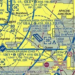
| Sectional chart |
|---|
|
CAUTION: Diagram may not be current
 Download PDF
of official airport diagram from the FAA
| Airport distance calculator |
|---|
|
|
| Sunrise and sunset |
|---|
|
Times for 30-May-2026
| | Local
(UTC-7) | | Zulu
(UTC) |
|---|
| Morning civil twilight | | 04:51 | | 11:51 |
| Sunrise | | 05:20 | | 12:20 |
| Sunset | | 19:29 | | 02:29 |
| Evening civil twilight | | 19:57 | | 02:57 |
|
| Current date and time |
|---|
| Zulu (UTC) | 31-May-2026 05:32:37 |
|---|
| Local (UTC-7) | 30-May-2026 22:32:37 |
|---|
|
| METAR |
|---|
| KIWA | 310450Z 00000KT 10SM CLR 27/00 A2987
|
KCHD
8nm W | 310515Z AUTO 00000KT 9SM CLR 27/03 A2986 RMK AO2 T02660025
|
KFFZ
10nm N | 310454Z 00000KT 10SM CLR 26/05 A2986 RMK AO2 SLP088 T02610050
|
|
| TAF |
|---|
| KIWA | 301720Z 3018/3118 28007KT P6SM SKC FM310600 12006KT P6SM SKC
|
|
| NOTAMs |
|---|
NOTAMs are issued by the DoD/FAA and will open in a separate window not controlled by AirNav.
|
|


