FAA INFORMATION EFFECTIVE 16 APRIL 2026
Location
| FAA Identifier: | MKE |
| Lat/Long: | 42-56-48.9550N 087-53-49.4320W
42-56.815917N 087-53.823867W
42.9469319,-87.8970644
(estimated) |
| Elevation: | 728.4 ft. / 222.0 m (surveyed) |
| Variation: | 04W (2020) |
| From city: | 5 miles S of MILWAUKEE, WI |
| Time zone: | UTC -5 (UTC -6 during Standard Time) |
| Zip code: | 53207 |
Airport Operations
| Airport use: | Open to the public |
| Control tower: | yes |
| ARTCC: | CHICAGO CENTER |
| FSS: | GREEN BAY FLIGHT SERVICE STATION |
| NOTAMs facility: | MKE (NOTAM-D service available) |
| Attendance: | CONTINUOUS |
| Wind indicator: | lighted |
| Segmented circle: | no |
| Beacon: | white-green (lighted land airport)
Operates sunset to sunrise. |
| Fire and rescue: | ARFF index C |
| Airline operations: | ARFF INDEX D EQUIP AVBL UPON REQUEST. |
| International operations: | customs landing rights airport |
Airport Communications
| UNICOM: | 122.95 |
| WX ASOS: | 126.4 (414-400-9402) |
| MILWAUKEE GROUND: | 121.8 263.125 |
| MILWAUKEE TOWER: | 124.575 269.05 |
| MILWAUKEE APPROACH: | 118.0 ;B SE 126.5 ;A NW 307.0 ;A NW 317.725 ;B SE |
| MILWAUKEE DEPARTURE: | 125.35 ;A NW 135.875 ;B SE 307.0 ;A NW 317.725 ;B SE |
| CLEARANCE DELIVERY: | 120.8 |
| CLASS C: | 118.0 ;B SE 126.5 ;A NW 307.0 ;A NW 317.725 ;B SE |
| COMD POST: | 321.0 ;128 ARW ANG UPSET CTL 6761 ;28 ARW ANG UPSET CON |
| D-ATIS: | 126.4 |
| EMERG: | 121.5 243.0 |
| GOPAC STAR: | 126.5 307.0 |
| IC: | 126.5 ;A NW 307.0 ;A NW |
| OPS: | 139.5 311.0 |
| RAMP CTL: | 129.05 ;CARGO RAMP DEICE/FOLLOW ME 129.05 ;SOUTH RAMP DEICE/FOLLOW ME 129.05 ;WEST RAMP DEICE/FOLLOW ME |
| WX AWOS-3 at MWC (12 nm NW): | PHONE 414-461-2954 |
| WX ASOS at RAC (12 nm S): | 121.425 (262-635-0959) |
| WX AWOS-3 at UES (16 nm W): | 118.875 (262-521-5226) |
- (A) WEST OF 1L-19R EXTENDED LOC CRS OF ACTIVE RWY AND NORTH OF 7R-25L EXTENDED CRS OF ACTIVE RWY.
- (B) EAST OF 1L-19R EXTENDED LOC CRS OF ACTIVE RWY AND SOUTH OF 7R-25L EXTENDED CRS OF ACTIVE RWY.
- ASDE-X IN USE. OPERATE TRANSPONDERS WITH ALTITUDE REPORTING MODE AND ADS-B (IF EQUIPPED) ENABLED ON ALL AIRPORT SURFACES.
Nearby radio navigation aids
| VOR radial/distance | | VOR name | | Freq | | Var |
|---|
| BAEr119/19.8 | | BADGER VOR/DME | | 116.40 | | 02E |
| BJBr162/(30.2) | | WEST BEND VOR | | 109.80 | | 01W |
| NDB name | | Hdg/Dist | | Freq | | Var | | ID |
|---|
| ROCK RIVER | | 112/38.8 | | 371 | | 01W | | RYV | .-. -.-- ...- |
Airport Services
| Fuel available: | 100LL JET-A
100LL:SERVICE-FUEL: A++ (MIL ANG) |
| Parking: | hangars |
| Airframe service: | MAJOR |
| Powerplant service: | MAJOR |
| Bottled oxygen: | NONE |
| Bulk oxygen: | HIGH |
Runway Information
Runway 1L/19R
| Dimensions: | 9990 x 200 ft. / 3045 x 61 m |
| Surface: | asphalt/concrete/grooved, in fair condition |
| Weight bearing capacity: | | Single wheel: | 100.0 | | Double wheel: | 185.0 | | Double tandem: | 350.0 |
|
| Runway edge lights: | high intensity |
| RUNWAY 1L | | RUNWAY 19R |
| Latitude: | 42-55.829938N | | 42-57.461650N |
| Longitude: | 087-53.858600W | | 087-53.579588W |
| Elevation: | 705.8 ft. | | 672.7 ft. |
| Traffic pattern: | left | | left |
| Runway heading: | 011 magnetic, 007 true | | 191 magnetic, 187 true |
| Displaced threshold: | 300 ft. | | 785 ft. |
| Declared distances: | TORA:9990 TODA:9990 ASDA:9380 LDA:9080 | | TORA:9990 TODA:9990 ASDA:9990 LDA:9205 |
| Markings: | precision, in good condition | | precision, in good condition |
| Visual slope indicator: | 4-light PAPI on right (3.00 degrees glide path) | | 4-light PAPI on right (3.00 degrees glide path) |
| RVR equipment: | touchdown, midfield, rollout | | touchdown, midfield, rollout |
| Approach lights: | ALSF2: standard 2,400 foot high intensity approach lighting system with centerline sequenced flashers (category II or III) | | MALSR: 1,400 foot medium intensity approach lighting system with runway alignment indicator lights |
| Runway end identifier lights: | no | | no |
| Centerline lights: | yes | | yes |
| Touchdown point: | yes, lighted | | yes, no lights |
| Instrument approach: | ILS/DME | | ILS/DME |
| Obstructions: | 82 ft. tree, 3758 ft. from runway, 985 ft. left of centerline, 44:1 slope to clear | | 6 ft. fence, 249 ft. from runway, 404 ft. right of centerline, 8:1 slope to clear
FENCE 148 FT FM THLD; 391 FT R OF CNTRLN. |
Runway 7R/25L
| Dimensions: | 8300 x 150 ft. / 2530 x 46 m |
| Surface: | asphalt/concrete/grooved, in fair condition |
| Weight bearing capacity: | | Single wheel: | 100.0 | | Double wheel: | 185.0 | | Double tandem: | 350.0 |
|
| Runway edge lights: | high intensity |
| RUNWAY 7R | | RUNWAY 25L |
| Latitude: | 42-56.344420N | | 42-56.774550N |
| Longitude: | 087-55.065195W | | 087-53.300005W |
| Elevation: | 728.4 ft. | | 669.9 ft. |
| Traffic pattern: | left | | left |
| Runway heading: | 076 magnetic, 072 true | | 256 magnetic, 252 true |
| Displaced threshold: | no | | 433 ft. |
| Declared distances: | TORA:8300 TODA:8300 ASDA:8012 LDA:8012 | | TORA:8300 TODA:8300 ASDA:8300 LDA:7867 |
| Markings: | precision, in good condition | | precision, in good condition |
| Visual slope indicator: | 4-light PAPI on left (3.00 degrees glide path) | | 4-light PAPI on left (3.00 degrees glide path) |
| RVR equipment: | touchdown | | rollout |
| Approach lights: | MALSR: 1,400 foot medium intensity approach lighting system with runway alignment indicator lights | | |
| Runway end identifier lights: | no | | yes |
| Touchdown point: | yes, no lights | | yes, no lights |
| Instrument approach: | ILS/DME | | LOC/DME |
| Obstructions: | 80 ft. tree, 3220 ft. from runway, 305 ft. left of centerline, 37:1 slope to clear | | 41 ft. pole, lighted, 456 ft. from runway, 464 ft. left of centerline, 8:1 slope to clear
APCH RATIO 29:1 TO DSPLCD THLD; 39 FT POLE, 1140 FT TO DSPLCD THLD; 544 FT L. |
Runway 13/31
| Dimensions: | 5537 x 150 ft. / 1688 x 46 m |
| Surface: | asphalt/concrete/grooved, in good condition |
| Weight bearing capacity: | | Single wheel: | 80.0 | | Double wheel: | 110.0 | | Double tandem: | 170.0 |
|
| Runway edge lights: | medium intensity |
| RUNWAY 13 | | RUNWAY 31 |
| Latitude: | 42-57.487945N | | 42-56.875123N |
| Longitude: | 087-54.204910W | | 087-53.286398W |
| Elevation: | 671.4 ft. | | 668.6 ft. |
| Traffic pattern: | left | | left |
| Runway heading: | 136 magnetic, 132 true | | 316 magnetic, 312 true |
| Displaced threshold: | 738 ft. | | 205 ft. |
| Declared distances: | TORA:5537 TODA:5537 ASDA:5537 LDA:4797 | | TORA:5537 TODA:5537 ASDA:5537 LDA:5152 |
| Markings: | nonprecision, in good condition | | nonprecision, in good condition |
| Visual slope indicator: | 4-light PAPI on left (3.00 degrees glide path) | | 4-light PAPI on right (3.00 degrees glide path) |
| Runway end identifier lights: | yes | | yes |
| Touchdown point: | yes, no lights | | yes, no lights |
| Obstructions: | 33 ft. pole, lighted, 816 ft. from runway, 69 ft. left of centerline, 18:1 slope to clear
APCH RATIO 27:1 TO DSPLCD THLD; 87 FT TREE 2375 FT TO DSPLCD THLD; 490 FT LEFT. | | 42 ft. rr, lighted, 626 ft. from runway, 295 ft. right of centerline, 10:1 slope to clear
APCH RATIO 27:1 TO DSPLCD THLD; 42 FT RR 1160 FT TO DSPLCD THLD; 290 FT R. |
Runway 7L/25R
| Dimensions: | 4797 x 100 ft. / 1462 x 30 m |
| Surface: | asphalt/concrete/grooved, in good condition |
| Weight bearing capacity: | | Single wheel: | 30.0 | | Double wheel: | 35.0 | | Double tandem: | 55.0 |
|
| Runway edge lights: | medium intensity |
| Operational restrictions: | RWY 07L/25R NOT AVBL FOR PART 121/PART 380 OPS WITH SKED PAX CARRYING OPS MORE THAN 9 PAX SEATS AND NON-SKED PAX CARRYING OPS MORE THAN 30 PAX SEATS. |
| RUNWAY 7L | | RUNWAY 25R |
| Latitude: | 42-57.164827N | | 42-57.413385N |
| Longitude: | 087-54.318502W | | 087-53.298217W |
| Elevation: | 671.5 ft. | | 674.6 ft. |
| Traffic pattern: | left | | left |
| Runway heading: | 076 magnetic, 072 true | | 256 magnetic, 252 true |
| Declared distances: | TORA:4797 TODA:4797 ASDA:4797 LDA:4797 | | TORA:4797 TODA:4797 ASDA:4797 LDA:4797 |
| Markings: | nonprecision, in good condition | | nonprecision, in good condition |
| Visual slope indicator: | 4-light PAPI on left (3.00 degrees glide path)
UNUSBL BYD 9 DEGS RIGHT AND LEFT OF CNTRLN. | | 4-light PAPI on right (3.00 degrees glide path) |
| Runway end identifier lights: | yes | | yes |
| Touchdown point: | yes, no lights | | yes, no lights |
| Obstructions: | 44 ft. tree, 1298 ft. from runway, 187 ft. right of centerline, 24:1 slope to clear | | 77 ft. pole, lighted, 1727 ft. from runway, 195 ft. right of centerline, 19:1 slope to clear |
Runway 1R/19L
| Dimensions: | 4182 x 150 ft. / 1275 x 46 m |
| Surface: | asphalt/concrete, in fair condition |
| Weight bearing capacity: | | Single wheel: | 85.0 | | Double wheel: | 115.0 | | Double tandem: | 180.0 |
|
| Runway edge lights: | medium intensity |
| RUNWAY 1R | | RUNWAY 19L |
| Latitude: | 42-56.362767N | | 42-57.045747N |
| Longitude: | 087-53.541693W | | 087-53.424797W |
| Elevation: | 677.7 ft. | | 669.6 ft. |
| Traffic pattern: | left | | left |
| Runway heading: | 011 magnetic, 007 true | | 191 magnetic, 187 true |
| Declared distances: | TORA:4182 TODA:4182 ASDA:4182 LDA:4182 | | TORA:4182 TODA:4182 ASDA:4182 LDA:4182 |
| Markings: | nonprecision, in good condition | | nonprecision, in good condition |
| Runway end identifier lights: | yes | | no |
| Touchdown point: | yes, no lights | | yes, no lights |
| Obstructions: | none | | 125 ft. tree, 4336 ft. from runway, 463 ft. left of centerline, 33:1 slope to clear |
Airport Ownership and Management from official FAA records
| Ownership: | Publicly-owned |
| Owner: | MILWAUKEE COUNTY
907 N 10TH ST
MILWAUKEE, WI 53233
Phone 414-747-5300 |
| Manager: | BRIAN DRANZIK
5300 S HOWELL AVE
MILWAUKEE, WI 53207
Phone 414-747-5775
EMAIL ADDRESS: BDRANZIK@MITCHELLAIRPORT.COM (ALL LOWER CASE) |
Additional Remarks
| A39-07R/25L | PCR VALUE: 1460/R/C/W/T |
| A39-01L/19R | PCR VALUE: 1280/R/C/W/T |
| A39-13/31 | PCR VALUE: 580/R/C/W/T |
| A39-07L/25R | PCR VALUE: 370/F/B/X/T |
| A39-01R/19L | PCR VALUE: 1540/R/C/W/T |
| - | RY 07L/25R CLSD TO ALL JET ACFT. |
| - | ALL APCHS ARE OVER NOISE SENSITIVE AREAS; ALL TURBOJET ACFT SHOULD REFRAIN FM CONDUCTING MULTI VFR TFC PATTERN APCHS & DEPS WO PRIOR APVL FM AMGR CALL C414-747-5325. |
| - | RY 13/31 CLSD JET ACFT, UNLESS PMSN FROM TWR OR AMGR 414-747-5325. |
| - | TRNG FLGTS INVOLVING SUCCESSIVE USE OF ANY RY PROHIBITED 2200-0600. |
| - | ACFT WITH WINGSPAN GREATER THAN 175 FT CANNOT PASS SIMULTANEOUSLY ON TWY 'E' & TWY 'Z'. |
| - | TWY F (WEST OF TWY Z) CLSD TO ACFT WITH WINGSPAN GREATER THAN OR EQUAL TO 118 FT UNLESS PERMISSION FROM ARPT DIR AT 414-747-5325. |
| - | RY 19R TODA 8,750 FT FROM INT TWY V. |
| - | TWY V BTN TWY D AND RY 7L/25R CLSD TO ACFT WITH WINGSPAN GREATER THAN 170 FT WHEN RY 7L/25R IN USE. |
| - | TWY B BTN TWY V AND TWY P CLSD TO AFCT WITH WINGSPAN GREATER THAN 170 FT. |
| - | RWY 13/31 & 07L/25R CLSD EXC LGT WT SNGL ENG ACFT 0400-1200Z DLY. |
| - | HOLDING BAY AT RY 19R WHEN IN USE, TWY Z ADJACENT TO BAY IS LIMITED TO ACFT WITH WINGSPAN UP TO 170 FT. |
| - | RWY 07L/25R NO ACFT 65,000 LBS OR GTR PMTD TO TAXI BTN TWY D & RWY 13/31 AND EAST OF RWY 19R UNLESS PMSN FROM AMGR. |
| - | RWY 01R-19L CLSD EXC TAX. |
| - | TWY S & TWY T BTN TWY R & RY 07R/25L AND RY 07R/25L BTN RY 1R/19L & TWY R CLSD DURG CAT II & III OPNS. |
| - | HOLDING BAY AT RY 01L CLSD EXCP ACFT WITH WINGSPAN LESS THAN 118 FT. |
| - | TWY A CLSD BTN TWY A4 AND TWY A5 TO ACFT WITH WINGSPAN GREATER THAN OR EQUAL TO 214' UNLESS PERMISSION FROM ARPT MGR 414-747-5325 |
| - | ALL ACFT PUSHBACKS FM GATES C20, C21, C22, C23, D39 D41 D43, D45, D48, D51, D53, D54, D55, RQR CLNC FM GC. PUSHBACKS FM ALL OTR GATES ARE AT RAMP/ PILOT DISCRETION; CTC GC WHEN READY TO TAXI. |
| - | TWY C CLSD BTWN APCH END OF RWY 7L AND WEST RAMP NORTH TXL TO ACFT WITH WINGSPAN GTR THAN OR EQUAL TO 118 FT UNLESS PMSN FM ARPT MGR 414-747-5325. |
| - | DEICE PAD FOR RWY 07R NOT AUTH FOR THRU TAXI. |
| - | TWY B BTN TWY R AND 750' WEST OF TWY R CLSD TO ACFT WINGSPAN MORE THAN 118 FT EXC PPR 414-747-5325. |
| - | TWY A BTN TWY R AND TWY A1 CLSD TO ACFT WINGSPAN MORE THAN 171 FT EXC PPR 414-747-5325. |
| - | TWY A CLSD FM TWY R TO TWY E AND TWY E CLSD FM TWY T TO TWY E1 AND TWY T CLSD N OF RWY 07R/25L, AND TWY M CLSD FM TWY E TO RWY 01R/19L TO ACFT WITH TAIL HGT GTR THAN 54.5 FT DURG CAT II AND CAT III OPS. |
| - | BIRDS ON & INVOF ARPT. |
| - | ACFT ARE NOT PERMITTED TO MAKE LEFT TURN ONTO TWY E WHEN EXITING TWY E2. |
| - | TWY F (E OF RWY 19R), TWY H, TWY J, AND TWY P CLSD TO ACFT WITH WINGSPAN GTR THAN 78 FT UNLESS PMSN FM AMGR AT 414-747-5325. |
| - | ANG: PPR ALL ACFT 48HR PN, CTC AFLD MGMT DSN 580-8241, C414-944-8241. AFLD MGMT HR 1200Z-2030Z++ MON-THURS, CLSD HOL, FRI-SUN EXC UNIT TMG. MAINT OPS (MOCC) FREQ - 379.85. ANY MDS (OTHER THAN KC-135) LTD TO STD TRAN MARSHALLING AND PRK. NO TECH DATA AVBL FOR TRAN MAINT. FUEL AND AGE SUPPORT AVBL FOR SELF-SVC. NO ADNL CONFIGN ITEMS SUPPORTED SUCH AS LANTIRN PODS, EDM PODS, ETC. ANG: EOR FAC, ACFT SHELTERS/REVETMENTS UNAVBL. APN HAS LTD STATIC GND POINTS AND TIE DOWN POINTS. FLEET SVC/HAZ CARGO CLASS 1.1., 1.2.1, 1.2.3. PRKG UNAVBL. PRE-COORD ALL TRANSPORTATION REQUIREMENTS AND HAZ CARGO WITH PPR REQ. CTC UPSET CTL ON 321.0 30 MIN PRIOR TO LDG. NSTD MRK ON APN FOR WINGTIP CLNC USED BY BASE ASGND ACFT, AND VEHICLE PRKG LINES PAINTED ON SE CORNER. |
| - | PREFERRED USAGE BY ACFT BTN 2200-0600 IS TKOF RY 19R & LNDG RY 01L. |
Instrument Procedures
NOTE: All procedures below are presented as PDF files. If you need a reader for these files, you should download the free Adobe Reader.NOT FOR NAVIGATION. Please procure official charts for flight.
FAA instrument procedures published for use from 16 April 2026 at 0901Z to 14 May 2026 at 0900Z.
STARs - Standard Terminal Arrivals |
|---|
| GOPAC THREE (RNAV) | |
download (234KB) |
IAPs - Instrument Approach Procedures |
|---|
| ILS OR LOC RWY 01L | |
download (277KB) |
| ILS OR LOC RWY 07R | |
download (270KB) |
| ILS OR LOC RWY 19R | |
download (283KB) |
| ILS RWY 01L (CAT II - III) | |
download (250KB) |
| RNAV (RNP) Y RWY 07R | |
download (313KB) |
| RNAV (RNP) Y RWY 25L | |
download (256KB) |
| RNAV (GPS) RWY 01L | |
download (268KB) |
| RNAV (GPS) RWY 01R | |
download (258KB) |
| RNAV (GPS) RWY 07L | |
download (256KB) |
| RNAV (GPS) RWY 13 | |
download (244KB) |
| RNAV (GPS) RWY 19L | |
download (250KB) |
| RNAV (GPS) RWY 19R | |
download (258KB) |
| RNAV (GPS) RWY 25R | |
download (220KB) |
| RNAV (GPS) RWY 31 | |
download (228KB) |
| RNAV (GPS) Z RWY 07R | |
download (240KB) |
| RNAV (GPS) Z RWY 25L | |
download (235KB) |
| LOC RWY 25L | |
download (237KB) |
Departure Procedures |
|---|
| ACCRA FIVE (RNAV) | |
download (188KB) |
| MITCHELL NINE | |
download (188KB) |
| UECKR SIX (RNAV) | |
download (203KB) |
| NOTE: Special Take-Off Minimums/Departure Procedures apply | |
download (483KB) |
Other nearby airports with instrument procedures:
KMWC - Lawrence J Timmerman Airport (12 nm NW)
KRAC - Batten International Airport (12 nm S)
KUES - Waukesha County Airport (16 nm W)
KENW - Kenosha Regional Airport (21 nm S)
57C - East Troy Municipal Airport (23 nm SW)
|
|

Road maps at:
MapQuest
Bing
Google
| Aerial photo |
|---|
WARNING: Photo may not be current or correct
 Photo by Dan Weber
Photo taken 23-Oct-2012
looking west.
Photo by Dan Weber
Photo taken 23-Oct-2012
looking west.
Do you have a better or more recent aerial photo of General Mitchell International Airport that you would like to share? If so, please send us your photo.
|
| Sectional chart |
|---|
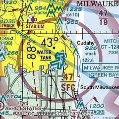
|
CAUTION: Diagram may not be current
 Download PDF
of official airport diagram from the FAA
| Airport distance calculator |
|---|
|
|
| Sunrise and sunset |
|---|
|
Times for 05-May-2026
| | Local
(UTC-5) | | Zulu
(UTC) |
|---|
| Morning civil twilight | | 05:10 | | 10:10 |
| Sunrise | | 05:41 | | 10:41 |
| Sunset | | 19:55 | | 00:55 |
| Evening civil twilight | | 20:27 | | 01:27 |
|
| Current date and time |
|---|
| Zulu (UTC) | 05-May-2026 08:27:48 |
|---|
| Local (UTC-5) | 05-May-2026 03:27:48 |
|---|
|
| METAR |
|---|
| KMKE | 050752Z 33015G24KT 10SM CLR 11/M03 A2963 RMK AO2 PK WND 34027/0727 SLP032 T01061028
|
KUES
11nm W | 050815Z AUTO 31006G15KT 10SM CLR 08/M02 A2968 RMK AO2
|
KRAC
11nm S | 050653Z AUTO 34015G21KT 10SM CLR 12/M01 A2963 RMK AO2 SLP030 T01171006
|
KMWC
11nm NW | 050815Z AUTO 32008KT 10SM CLR 07/M03 A2968 RMK AO2
|
|
| TAF |
|---|
| KMKE | 050520Z 0506/0612 31011G18KT P6SM SCT120 FM050800 32006KT P6SM BKN200 FM051000 31005KT P6SM BKN250 FM051700 29007KT P6SM BKN070 FM060300 VRB03KT P6SM SCT200
|
KUES
11nm W | 050520Z 0506/0606 31010G15KT P6SM SCT120 FM050800 31006KT P6SM SCT200 FM051600 29008KT P6SM BKN070 FM060000 31005KT P6SM BKN070 FM060300 00000KT P6SM SCT200
|
|
| NOTAMs |
|---|
NOTAMs are issued by the DoD/FAA and will open in a separate window not controlled by AirNav.
|
|


