FAA INFORMATION EFFECTIVE 19 MARCH 2026
Location
| FAA Identifier: | ONM |
| Lat/Long: | 34-01-20.9000N 106-54-11.3000W
34-01.348333N 106-54.188333W
34.0224722,-106.9031389
(estimated) |
| Elevation: | 4875.2 ft. / 1486.0 m (surveyed) |
| Variation: | 09E (2010) |
| From city: | 3 miles S of SOCORRO, NM |
| Time zone: | UTC -6 (UTC -7 during Standard Time) |
| Zip code: | 87801 |
Airport Operations
| Airport use: | Open to the public |
| Activation date: | 04/1940 |
| Control tower: | no |
| ARTCC: | ALBUQUERQUE CENTER |
| FSS: | ALBUQUERQUE FLIGHT SERVICE STATION |
| NOTAMs facility: | ABQ (NOTAM-D service available) |
| Attendance: | UNATNDD
EMERG - 505-507-2800. |
| Wind indicator: | lighted |
| Segmented circle: | yes |
| Lights: | ACTVT PAPI RWY 15; PAPI RWY 33; MIRL RWY 06/24 & 15/33 - CTAF. MIRL RWY 15/33 PRESET LOW INTST; INCR INTST - CTAF. |
| Beacon: | white-green (lighted land airport)
Operates sunset to sunrise. |
Airport Communications
| CTAF/UNICOM: | 122.8 |
| WX AWOS-3: | 118.325 (575-838-3993) |
- APCH/DEP SVC PRVDD BY ALBUQUERQUE ARTCC (ZAB) ON FREQS 124.325/288.25 (ZUNI RCAG).
Nearby radio navigation aids
| VOR radial/distance | | VOR name | | Freq | | Var |
|---|
| ONMr179/19.4 | | SOCORRO VORTAC | | 116.80 | | 13E |
Airport Services
| Fuel available: | 100LL
100LL:AVBL H24 WITH CREDIT CARD. |
| Parking: | tiedowns |
Runway Information
Runway 15/33
| Dimensions: | 5841 x 75 ft. / 1780 x 23 m |
| Surface: | asphalt, in good condition |
| Weight bearing capacity: | | PCN 9 /F/D/Y/T | | Single wheel: | 50.0 | | Double wheel: | 75.0 |
|
| Runway edge lights: | medium intensity |
| Operational restrictions: | +4-7 FT BRUSH IN PRIM SFC 70-250 FT FM CNTRLN W SIDE & S OF RWY 06/24. |
| RUNWAY 15 | | RUNWAY 33 |
| Latitude: | 34-01.764417N | | 34-00.841200N |
| Longitude: | 106-54.165650W | | 106-53.837583W |
| Elevation: | 4798.5 ft. | | 4744.2 ft. |
| Traffic pattern: | left | | left |
| Runway heading: | 155 magnetic, 164 true | | 335 magnetic, 344 true |
| Displaced threshold: | 186 ft. | | 182 ft. |
| Markings: | nonprecision, in good condition | | nonprecision, in good condition |
| Visual slope indicator: | 2-light PAPI on left (4.00 degrees glide path) | | 2-light PAPI on left (4.00 degrees glide path) |
| Touchdown point: | yes, no lights | | yes, no lights |
Runway 6/24
| Dimensions: | 4590 x 60 ft. / 1399 x 18 m |
| Surface: | asphalt, in good condition |
| Weight bearing capacity: | |
| Runway edge lights: | medium intensity |
| Operational restrictions: | 4-8 FT BRUSH IN PRIM SFC 50-125 FT FM CNTRLN S SIDE & 60-125 FT FM CNTRLN N SIDE. |
| RUNWAY 6 | | RUNWAY 24 |
| Latitude: | 34-01.298750N | | 34-01.513300N |
| Longitude: | 106-54.861367W | | 106-53.990267W |
| Elevation: | 4875.2 ft. | | 4785.4 ft. |
| Traffic pattern: | left | | left |
| Runway heading: | 065 magnetic, 074 true | | 245 magnetic, 254 true |
| Markings: | basic, in good condition | | basic, in good condition |
| Touchdown point: | yes, no lights | | yes, no lights |
Airport Ownership and Management from official FAA records
| Ownership: | Publicly-owned |
| Owner: | CITY OF SOCORRO
PO BOX K
SOCORRO, NM 87801
Phone 575-835-2490 |
| Manager: | ISAAC ANGEL
PO BOX K
SOCORRO, NM 87801
Phone 505-507-2800 |
Additional Remarks
| A30A-33 | -20 FT DROP OFF 100 FT FM THR BOTH SIDES. |
| A30A-15 | -40 FT DROP OFF 175 FT FM THR BOTH SIDES. |
| A57-33 | 0:1 TO DTHR DUE TO 3-4 FT BRUSH 120-250 FT L OF CNTRLN AT DTHR. |
| A57-15 | 50:1 TO DTHR. |
| - | GATE CODE 4850. |
| - | FOR CD CTC ALBUQUERQUE ARTCC AT 505-856-4561. |
| A58-33 | 1-2 FT BRUSH 20-100 FT FM THR L & R OF CNTRLN. |
| A58-15 | 1-3FT BRUSH 20-80 FT FM THR BOTH SIDES; 3 FT FENCE 80 FT FM THR 60 FT L OF CNTRLN. |
Instrument Procedures
NOTE: All procedures below are presented as PDF files. If you need a reader for these files, you should download the free Adobe Reader.NOT FOR NAVIGATION. Please procure official charts for flight.
FAA instrument procedures published for use from 19 March 2026 at 0901Z to 16 April 2026 at 0900Z.
IAPs - Instrument Approach Procedures |
|---|
| RNAV (GPS) RWY 33 | |
download (326KB) |
| VOR/DME-A | |
download (248KB) |
| NOTE: Special Take-Off Minimums/Departure Procedures apply | |
download (105KB) |
Other nearby airports with instrument procedures:
KBRG - Belen Regional Airport (38 nm N)
KTCS - Truth or Consequences Municipal Airport (51 nm S)
KABQ - Albuquerque International Sunport Airport (63 nm N)
KAEG - Double Eagle II Airport (68 nm N)
0E0 - Moriarty Municipal Airport (73 nm NE)
|
|

Road maps at:
MapQuest
Bing
Google
| Aerial photo |
|---|
WARNING: Photo may not be current or correct

Do you have a better or more recent aerial photo of Socorro Municipal Airport that you would like to share? If so, please send us your photo.
|
| Sectional chart |
|---|
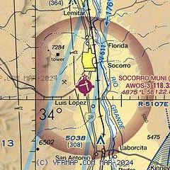
|
| Airport distance calculator |
|---|
|
|
| Sunrise and sunset |
|---|
|
Times for 14-Apr-2026
| | Local
(UTC-6) | | Zulu
(UTC) |
|---|
| Morning civil twilight | | 06:13 | | 12:13 |
| Sunrise | | 06:39 | | 12:39 |
| Sunset | | 19:37 | | 01:37 |
| Evening civil twilight | | 20:03 | | 02:03 |
|
| Current date and time |
|---|
| Zulu (UTC) | 14-Apr-2026 17:31:08 |
|---|
| Local (UTC-6) | 14-Apr-2026 11:31:08 |
|---|
|
| METAR |
|---|
| KONM | 141715Z AUTO 20010G16KT 10SM CLR 20/M03 A2999 RMK AO2 T01981035
|
|
| NOTAMs |
|---|
NOTAMs are issued by the DoD/FAA and will open in a separate window not controlled by AirNav.
|
|


