FAA INFORMATION EFFECTIVE 16 APRIL 2026
Location
| FAA Identifier: | PGV |
| Lat/Long: | 35-38-08.5000N 077-23-02.7000W
35-38.141667N 077-23.045000W
35.6356944,-77.3840833
(estimated) |
| Elevation: | 26.4 ft. / 8.0 m (surveyed) |
| Variation: | 09W (2000) |
| From city: | 2 miles N of GREENVILLE, NC |
| Time zone: | UTC -4 (UTC -5 during Standard Time) |
| Zip code: | 27834 |
Airport Operations
| Airport use: | Open to the public |
| Activation date: | 06/1941 |
| Control tower: | no |
| ARTCC: | WASHINGTON CENTER |
| FSS: | RALEIGH FLIGHT SERVICE STATION |
| NOTAMs facility: | PGV (NOTAM-D service available) |
| Attendance: | CONTINUOUS |
| Wind indicator: | lighted |
| Segmented circle: | yes |
| Lights: | ACTVT MALSR RWY 20; PAPI RWYS 02, 20, 08 & 26; HIRL RWY 02/20; MIRL RWY 08/26 - CTAF. |
| Beacon: | white-green (lighted land airport)
Operates sunset to sunrise. |
| Fire and rescue: | ARFF index B |
| Airline operations: | ARPT CLSD TO UNSKED ACR OPS EXCP 8 HRS PPR 252-902-2026 DAILY 0200-1000. INDEX C ARFF EQUIP AVBL UPON REQ. |
Airport Communications
| CTAF/UNICOM: | 122.8 |
| WX AWOS-3: | 128.425 (252-758-6485) |
| WX AWOS-3 at OCW (17 nm E): | 120.175 (252-975-6133) |
| WX AWOS-3P at MCZ (17 nm NE): | 118.65 (252-802-4261) |
| WX AWOS-3P at ETC (20 nm NW): | 119.575 (252-641-1640) |
- CLEARANCE DELIVERY PRVDD BY RALEIGH RADIO ON FREQ 122.2 (PITT-GREENVILLE RCO).
- APCH/DEP SVC PRVDD BY WASHINGTON ARTCC (ZDC) ON 123.85/279.65 (NEW BERN RCAG).
Nearby radio navigation aids
| VOR radial/distance | | VOR name | | Freq | | Var |
|---|
| ISOr033/18.0 | | KINSTON VORTAC | | 117.50 | | 05W |
| TYIr148/25.7 | | TAR RIVER VORTAC | | 117.80 | | 05W |
| EWNr342/37.6 | | NEW BERN VOR/DME | | 113.60 | | 08W |
| NDB name | | Hdg/Dist | | Freq | | Var | | ID |
|---|
| ALWOOD | | 197/4.3 | | 230 | | 09W | | AQE | .- --.- . |
| CHOCOWINITY | | 307/15.5 | | 388 | | 08W | | RNW | .-. -. .-- |
Airport Services
| Fuel available: | 100LL JET-A |
| Parking: | hangars and tiedowns |
| Airframe service: | MAJOR |
| Powerplant service: | MAJOR |
| Bottled oxygen: | NONE |
| Bulk oxygen: | NONE |
Runway Information
Runway 2/20
| Dimensions: | 7175 x 150 ft. / 2187 x 46 m |
| Surface: | asphalt/grooved, in good condition |
| Weight bearing capacity: | | Single wheel: | 85.0 | | Double wheel: | 140.0 |
|
| Runway edge lights: | high intensity |
| RUNWAY 2 | | RUNWAY 20 |
| Latitude: | 35-37.552045N | | 35-38.724362N |
| Longitude: | 077-23.148038W | | 077-22.957177W |
| Elevation: | 20.7 ft. | | 26.3 ft. |
| Traffic pattern: | left | | left |
| Runway heading: | 017 magnetic, 008 true | | 197 magnetic, 188 true |
| Displaced threshold: | 271 ft. | | no |
| Declared distances: | TORA:7175 TODA:7175 ASDA:7175 LDA:6905 | | TORA:7175 TODA:7175 ASDA:6505 LDA:6505 |
| Markings: | precision, in good condition | | precision, in good condition |
| Visual slope indicator: | 4-light PAPI on left (3.10 degrees glide path) | | 4-light PAPI on left (3.00 degrees glide path) |
| Approach lights: | | | MALSR: 1,400 foot medium intensity approach lighting system with runway alignment indicator lights |
| Runway end identifier lights: | yes | | no |
| Touchdown point: | yes, no lights | | yes, no lights |
| Instrument approach: | | | ILS/DME |
| Obstructions: | 13 ft. trees, 1000 ft. from runway, 200 ft. right of centerline, 33:1 slope to clear | | 65 ft. trees, 2800 ft. from runway, 800 ft. left of centerline, 40:1 slope to clear |
Runway 8/26
| Dimensions: | 4997 x 150 ft. / 1523 x 46 m |
| Surface: | asphalt, in poor condition
RUNWAY 8-26 NOT AVAILABLE FOR AIR CARRIER USE; UNEVEN SURFACE. |
| Weight bearing capacity: | | Single wheel: | 45.0 | | Double wheel: | 73.0 |
|
| Runway edge lights: | medium intensity |
| Runway edge markings: | RUNWAY 8-26 MARKINGS LACK VISIBILITY |
| Operational restrictions: | RWY 08/26 NOT AVBL FOR PART 121/PART 380 OPS WITH SKED PAX CARRYING OPS MORE THAN 9 PAX SEATS AND NON-SKED PAX CARRYING OPS MORE THAN 30 PAX SEATS. |
| RUNWAY 8 | | RUNWAY 26 |
| Latitude: | 35-37.984022N | | 35-38.309412N |
| Longitude: | 077-23.497195W | | 077-22.570305W |
| Elevation: | 24.0 ft. | | 23.3 ft. |
| Traffic pattern: | left | | left |
| Runway heading: | 076 magnetic, 067 true | | 256 magnetic, 247 true |
| Declared distances: | TORA:4997 TODA:4997 ASDA:4997 LDA:4997 | | TORA:4997 TODA:4997 ASDA:4997 LDA:4997 |
| Markings: | nonprecision, in poor condition | | nonprecision, in poor condition |
| Visual slope indicator: | 4-light PAPI on left (4.00 degrees glide path) | | 4-light PAPI on left (3.00 degrees glide path) |
| Runway end identifier lights: | yes | | yes |
| Touchdown point: | yes, no lights | | yes, no lights |
| Obstructions: | 110 ft. trees, 1526 ft. from runway, 200 ft. right of centerline, 12:1 slope to clear | | 37 ft. pole, lighted, 1441 ft. from runway, 77 ft. right of centerline, 33:1 slope to clear |
Airport Ownership and Management from official FAA records
| Ownership: | Publicly-owned |
| Owner: | PITT CO & GREENVILLE CITY
400 AIRPORT RD
GREENVILLE, NC 27834
Phone 252-902-2026 |
| Manager: | KIM W BILL HOPPER
400 AIRPORT RD
GREENVILLE, NC 27834
Phone 252-902-2026 |
Additional Remarks
| A39-02/20 | PCR VALUE: 326/F/B/X/T |
| A39-08/26 | PCR VALUE: 153/F/B/X/T |
| - | 24 HR HELICOPTER OPNS AT HOSPITAL 1.5 NM SSW OF ARPT; MONITORING CTAF. |
| - | JET ACFT DEPARTING FROM RWY 20 SHALL HOLD ON AIR CARRIER OR GA APRON UNTIL TAKE OFF CLEARANCE IS RECEIVED. |
| - | FOR CD IF UNA TO CTC ON FSS FREQ, CTC WASHINGTON ARTCC AT 703-771-3587. |
Instrument Procedures
NOTE: All procedures below are presented as PDF files. If you need a reader for these files, you should download the free Adobe Reader.NOT FOR NAVIGATION. Please procure official charts for flight.
FAA instrument procedures published for use from 16 April 2026 at 0901Z to 14 May 2026 at 0900Z.
IAPs - Instrument Approach Procedures |
|---|
| ILS Y OR LOC Y RWY 20 | |
download (282KB) |
| ILS Z OR LOC Z RWY 20 | |
download (292KB) |
| RNAV (GPS) RWY 02 | |
download (239KB) |
| RNAV (GPS) RWY 08 | |
download (202KB) |
| RNAV (GPS) RWY 20 | |
download (247KB) |
| RNAV (GPS) RWY 26 | |
download (242KB) |
| NOTE: Special Alternate Minimums apply | |
download (143KB) |
| NOTE: Special Take-Off Minimums/Departure Procedures apply | |
download (209KB) |
Other nearby airports with instrument procedures:
KOCW - Washington-Warren Airport (17 nm E)
KMCZ - Martin County Airport (17 nm NE)
KETC - Tarboro-Edgecombe Airport (20 nm NW)
KISO - Kinston Regional Jetport at Stallings Field (21 nm SW)
KRWI - Rocky Mount/Wilson Regional Airport (28 nm NW)
|
|

Road maps at:
MapQuest
Bing
Google
| Aerial photo |
|---|
WARNING: Photo may not be current or correct
 Photo by Blue Line Aviation
Photo taken 11-Aug-2013
from 7,000 ft looking northeast.
Photo by Blue Line Aviation
Photo taken 11-Aug-2013
from 7,000 ft looking northeast.
Do you have a better or more recent aerial photo of Pitt-Greenville Airport that you would like to share? If so, please send us your photo.
|
| Sectional chart |
|---|
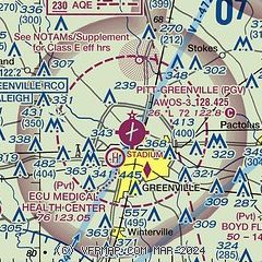
|
 Download PDF
of official airport diagram from the FAA
| Airport distance calculator |
|---|
|
|
| Sunrise and sunset |
|---|
|
Times for 19-Apr-2026
| | Local
(UTC-4) | | Zulu
(UTC) |
|---|
| Morning civil twilight | | 06:06 | | 10:06 |
| Sunrise | | 06:33 | | 10:33 |
| Sunset | | 19:45 | | 23:45 |
| Evening civil twilight | | 20:11 | | 00:11 |
|
| Current date and time |
|---|
| Zulu (UTC) | 19-Apr-2026 21:51:18 |
|---|
| Local (UTC-4) | 19-Apr-2026 17:51:18 |
|---|
|
| METAR |
|---|
| KPGV | 192135Z AUTO 36007KT 10SM FEW080 13/09 A3003 RMK AO2
|
KOCW
17nm E | 192130Z AUTO 32008KT 10SM SCT019 BKN065 OVC075 12/08 A3003 RMK AO2 T01240083
|
KMCZ
17nm NE | 192135Z AUTO 33005KT 10SM SCT100 13/10 A3004 RMK AO2 T01250101
|
KETC
20nm NW | 192130Z AUTO 36003KT 7SM CLR 13/08 A3003 RMK AO2 T01330083
|
|
| TAF |
|---|
| KPGV | 191745Z 1918/2018 34012G22KT P6SM -RA OVC040 TEMPO 1918/1921 BKN025 FM192100 01010KT P6SM OVC060 FM192300 VRB03KT P6SM SKC FM201500 27008G16KT P6SM SCT070 AMD LTD TO CLD VIS AND WIND
|
|
| NOTAMs |
|---|
NOTAMs are issued by the DoD/FAA and will open in a separate window not controlled by AirNav.
|
|


