FAA INFORMATION EFFECTIVE 14 MAY 2026
Location
| FAA Identifier: | MRJ |
| Lat/Long: | 42-53-12.7680N 090-14-11.9970W
42-53.212800N 090-14.199950W
42.8868800,-90.2366658
(estimated) |
| Elevation: | 1170.7 ft. / 356.8 m (surveyed) |
| Variation: | 00W (2000) |
| From city: | 3 miles NW of MINERAL POINT, WI |
| Time zone: | UTC -5 (UTC -6 during Standard Time) |
| Zip code: | 53565 |
Airport Operations
| Airport use: | Open to the public |
| Activation date: | 04/1962 |
| Control tower: | no |
| ARTCC: | CHICAGO CENTER |
| FSS: | GREEN BAY FLIGHT SERVICE STATION |
| NOTAMs facility: | MRJ (NOTAM-D service available) |
| Attendance: | MON-FRI 0600-1600, ALL SAT-SUN ON CALL |
| Wind indicator: | yes |
| Segmented circle: | no |
| Lights: | MIRL RWY 11/29 PRESET TO LOW SS-SR; TO INCR INTST AND ACTVT PAPI RWY 04, 11, 22 & 29; MIRL RWY 04/22 - CTAF. |
| Beacon: | white-green (lighted land airport)
Operates sunset to sunrise. |
Airport Communications
| CTAF/UNICOM: | 122.8 |
| WX AWOS-3: | 118.525 (608-987-2157) |
| WX AWOS-3 at PVB (15 nm SW): | 120.575 (608-348-3637) |
| WX ASOS at LNR (20 nm N): | 119.425 (608-583-2576) |
- APCH/DEP SVC PRVDD BY CHICAGO ARTCC ON FREQS 133.95/281.4 (DUBUQUE RCAG).
Nearby radio navigation aids
| VOR radial/distance | | VOR name | | Freq | | Var |
|---|
| DBQr032/35.8 | | DUBUQUE VORTAC | | 115.80 | | 04E |
Airport Services
| Fuel available: | 100LL JET-A+
100LL:FUEL AVBL 24 HR SELF SVC. |
| Parking: | hangars and tiedowns |
| Airframe service: | MAJOR |
| Powerplant service: | MAJOR |
| Bottled oxygen: | LOW |
| Bulk oxygen: | NONE |
Runway Information
Runway 11/29
| Dimensions: | 5001 x 75 ft. / 1524 x 23 m |
| Surface: | asphalt, in excellent condition |
| Runway edge lights: | medium intensity |
| RUNWAY 11 | | RUNWAY 29 |
| Latitude: | 42-53.425132N | | 42-53.133677N |
| Longitude: | 090-14.926112W | | 090-13.879382W |
| Elevation: | 1129.1 ft. | | 1163.9 ft. |
| Traffic pattern: | left | | left |
| Runway heading: | 111 magnetic, 111 true | | 291 magnetic, 291 true |
| Markings: | nonprecision, in good condition | | nonprecision, in good condition |
| Visual slope indicator: | 2-light PAPI on left (3.00 degrees glide path) | | 2-light PAPI on left (3.00 degrees glide path) |
| Runway end identifier lights: | no | | no |
| Touchdown point: | yes, no lights | | yes, no lights |
Runway 4/22
| Dimensions: | 3600 x 60 ft. / 1097 x 18 m |
| Surface: | asphalt, in good condition |
| Weight bearing capacity: | |
| Runway edge lights: | medium intensity |
| RUNWAY 4 | | RUNWAY 22 |
| Latitude: | 42-52.893905N | | 42-53.346570N |
| Longitude: | 090-14.178320W | | 090-13.658295W |
| Elevation: | 1163.7 ft. | | 1170.6 ft. |
| Traffic pattern: | left | | left |
| Runway heading: | 040 magnetic, 040 true | | 220 magnetic, 220 true |
| Markings: | nonprecision, in good condition | | nonprecision, in good condition |
| Visual slope indicator: | 2-light PAPI on left (3.00 degrees glide path) | | 2-light PAPI on left (3.00 degrees glide path) |
| Touchdown point: | yes, no lights | | yes, no lights |
Airport Ownership and Management from official FAA records
| Ownership: | Publicly-owned |
| Owner: | IOWA COUNTY
222 N. IOWA STREET
DODGEVILLE, WI 53533
Phone 608-987-9931 |
| Manager: | CODY WILLIAMS
3151 STATE RD 39
MINERAL POINT, WI 53565
Phone 608-553-7571 |
Additional Remarks
| - | BIRDS ON & INVOF ARPT. |
| - | FOR NOISE ABATEMENT PREFERED NO WIND RY IS RY 29. |
| - | FOR CD CTC CHICAGO ARTCC AT 630-906-8921. |
Instrument Procedures
NOTE: All procedures below are presented as PDF files. If you need a reader for these files, you should download the free Adobe Reader.NOT FOR NAVIGATION. Please procure official charts for flight.
FAA instrument procedures published for use from 14 May 2026 at 0901Z to 11 June 2026 at 0900Z.
IAPs - Instrument Approach Procedures |
|---|
| RNAV (GPS) RWY 04 | |
download (223KB) |
| RNAV (GPS) RWY 11 | |
download (205KB) |
| RNAV (GPS) RWY 22 | |
download (236KB) |
| RNAV (GPS) RWY 29 | |
download (225KB) |
| NOTE: Special Alternate Minimums apply | |
download (59KB) |
| NOTE: Special Take-Off Minimums/Departure Procedures apply | |
download (201KB) |
Other nearby airports with instrument procedures:
KPVB - Platteville Municipal Airport (15 nm SW)
KLNR - Tri-County Regional Airport (20 nm N)
93C - Richland Airport (24 nm N)
KOVS - Boscobel Airport (25 nm NW)
91C - Sauk/Prairie Airport (32 nm NE)
|
|

Road maps at:
MapQuest
Bing
Google
| Aerial photo |
|---|
WARNING: Photo may not be current or correct
 Taken in the Summer of 2002
Do you have a better or more recent aerial photo of Iowa County Airport that you would like to share? If so, please send us your photo.
|
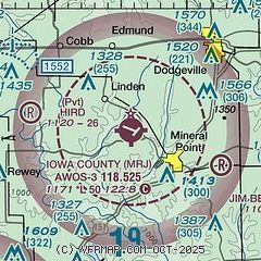
| Sectional chart |
|---|
|
| Airport distance calculator |
|---|
|
|
| Sunrise and sunset |
|---|
|
Times for 25-May-2026
| | Local
(UTC-5) | | Zulu
(UTC) |
|---|
| Morning civil twilight | | 04:56 | | 09:56 |
| Sunrise | | 05:30 | | 10:30 |
| Sunset | | 20:26 | | 01:26 |
| Evening civil twilight | | 20:59 | | 01:59 |
|
| Current date and time |
|---|
| Zulu (UTC) | 25-May-2026 11:55:24 |
|---|
| Local (UTC-5) | 25-May-2026 06:55:24 |
|---|
|
| METAR |
|---|
KPVB
15nm SW | 251135Z AUTO 00000KT 10SM SCT120 17/10 A3011 RMK AO1 T01650101
|
KLNR
20nm N | 251056Z AUTO 00000KT 10SM FEW120 13/12 A3007 RMK AO2 SLP177 T01330122
|
|
| TAF |
|---|
KDBQ
36nm SW | 250520Z 2506/2606 20009KT P6SM SCT100 FM251700 20013G22KT P6SM FEW080 FM260000 19009KT P6SM SKC
|
KMSN
42nm E | 250857Z 2509/2606 19003KT P6SM SCT200 FM251200 19003KT P6SM BKN150 FM251500 22006KT P6SM BKN100 FM251900 22010KT P6SM SCT100 FM260000 21007KT P6SM SKC
|
|
| NOTAMs |
|---|
NOTAMs are issued by the DoD/FAA and will open in a separate window not controlled by AirNav.
|
|

