FAA INFORMATION EFFECTIVE 14 MAY 2026
Location
| FAA Identifier: | RDU |
| Lat/Long: | 35-52-39.5000N 078-47-14.9000W
35-52.658333N 078-47.248333W
35.8776389,-78.7874722
(estimated) |
| Elevation: | 435.2 ft. / 132.6 m (surveyed) |
| Variation: | 09W (2020) |
| From city: | 9 miles NW of central business district of the associated city |
| Time zone: | UTC -4 (UTC -5 during Standard Time) |
| Zip code: | 27612 |
Airport Operations
| Airport use: | Open to the public |
| Activation date: | 04/1943 |
| Control tower: | yes |
| ARTCC: | WASHINGTON CENTER |
| FSS: | RALEIGH FLIGHT SERVICE STATION |
| NOTAMs facility: | RDU (NOTAM-D service available) |
| Attendance: | CONTINUOUS |
| Wind indicator: | lighted |
| Segmented circle: | no |
| Lights: | SS-SR |
| Beacon: | white-green (lighted land airport)
VISIBILITY OF BCN SHIELDED TO THE NORTH. Operates sunset to sunrise. |
| Fire and rescue: | ARFF index D |
| International operations: | customs landing rights airport |
Airport Communications
| UNICOM: | 122.95 |
| WX ASOS: | PHONE 919-244-2891 |
| RALEIGH GROUND: | 121.9 348.6 |
| RALEIGH TOWER: | 127.45 257.8 |
| RALEIGH APPROACH: | 124.95 ;055-229 127.675 ;230-054 307.9 ;230-054 318.2 ;055-229 |
| RALEIGH DEPARTURE: | 125.3 ;055-229 132.35 ;230-054 256.9 ;230-054 353.675 ;055-229 353.675 ;SOUTH |
| CLEARANCE DELIVERY: | 120.1 |
| BEXGO DP: | 132.35 256.9 |
| BLOGS STAR: | 124.95 318.2 |
| BRADE STAR: | 124.95 318.2 |
| BUZZY STAR: | 127.675 307.9 |
| CLASS C: | 125.3 ;055-229 132.35 ;230-054 256.9 ;230-054 353.675 ;055-229 |
| D-ATIS: | 123.8 |
| DMSTR STAR: | 127.675 307.9 |
| EMERG: | 121.5 |
| FINAL: | 285.425 ;EAST |
| HOOKZ DP: | 125.3 353.675 |
| HURIC DP: | 125.3 353.675 |
| IC: | 127.675 ;230-054 307.9 ;230-054 |
| LWOOD DP: | 132.35 256.9 |
| OXFRD DP: | 132.35 256.9 |
| PACKK DP: | 125.3 ;055-229 132.35 ;230-054 256.9 ;230-054 353.675 ;055-229 |
| RALEIGH DP: | 125.3 ;055-229 132.35 ;230-054 256.9 ;230-054 353.675 ;055-229 |
| ROZBO DP: | 125.3 353.675 |
| SHPRD DP: | 132.35 256.9 |
| TAQLE STAR: | 124.95 318.2 |
Nearby radio navigation aids
| VOR radial/distance | | VOR name | | Freq | | Var |
|---|
| RDU at field | | RALEIGH/DURHAM VORTAC | | 117.20 | | 09W |
| NDB name | | Hdg/Dist | | Freq | | Var | | ID |
|---|
| HUNTSBORO | | 207/26.7 | | 271 | | 09W | | HXO | .... -..- --- |
Airport Services
| Fuel available: | 100LL JET-A |
| Parking: | hangars and tiedowns |
| Airframe service: | MAJOR |
| Powerplant service: | MAJOR |
| Bottled oxygen: | NONE |
| Bulk oxygen: | HIGH/LOW |
Runway Information
Runway 5L/23R
| Dimensions: | 10000 x 150 ft. / 3048 x 46 m |
| Surface: | concrete/wired/combed, in good condition |
| Weight bearing capacity: | | Single wheel: | 75.0 | | Double wheel: | 190.0 | | Double tandem: | 355.0 | | Dual double tandem: | 750.0 |
|
| Runway edge lights: | high intensity |
| Operational restrictions: | RWY 05L/23R UNGROOVED. |
| RUNWAY 5L | | RUNWAY 23R |
| Latitude: | 35-52.466933N | | 35-53.629428N |
| Longitude: | 078-48.117817W | | 078-46.681997W |
| Elevation: | 366.8 ft. | | 408.6 ft. |
| Traffic pattern: | left | | right |
| Runway heading: | 054 magnetic, 045 true | | 234 magnetic, 225 true |
| Declared distances: | TORA:10000 TODA:10000 ASDA:10000 LDA:10000 | | TORA:10000 TODA:10000 ASDA:10000 LDA:10000 |
| Markings: | precision, in good condition | | precision, in good condition |
| Visual slope indicator: | 4-light PAPI on left (3.00 degrees glide path) | | 4-light PAPI on left (3.00 degrees glide path) |
| RVR equipment: | touchdown, midfield, rollout | | touchdown, midfield, rollout |
| Approach lights: | MALSR: 1,400 foot medium intensity approach lighting system with runway alignment indicator lights | | ALSF2: standard 2,400 foot high intensity approach lighting system with centerline sequenced flashers (category II or III) |
| Centerline lights: | yes | | yes |
| Touchdown point: | yes, lighted | | yes, lighted |
| Instrument approach: | ILS/DME | | ILS/DME |
Runway 5R/23L
| Dimensions: | 7500 x 150 ft. / 2286 x 46 m |
| Surface: | asphalt/grooved, in good condition |
| Weight bearing capacity: | | Single wheel: | 75.0 | | Double wheel: | 176.0 | | Double tandem: | 335.0 | | Dual double tandem: | 750.0 |
|
| Runway edge lights: | high intensity |
| RUNWAY 5R | | RUNWAY 23L |
| Latitude: | 35-51.877807N | | 35-52.749720N |
| Longitude: | 078-47.840290W | | 078-46.763618W |
| Elevation: | 397.5 ft. | | 430.7 ft. |
| Traffic pattern: | right | | left |
| Runway heading: | 054 magnetic, 045 true | | 234 magnetic, 225 true |
| Declared distances: | TORA:7500 TODA:7500 ASDA:7500 LDA:7500 | | TORA:7500 TODA:7500 ASDA:7500 LDA:7500 |
| Markings: | precision, in good condition | | precision, in good condition |
| Visual slope indicator: | 4-light PAPI on left (3.00 degrees glide path) | | 4-light PAPI on left (3.00 degrees glide path) |
| RVR equipment: | touchdown, rollout | | touchdown, rollout |
| Approach lights: | MALSR: 1,400 foot medium intensity approach lighting system with runway alignment indicator lights | | MALSR: 1,400 foot medium intensity approach lighting system with runway alignment indicator lights |
| Runway end identifier lights: | no | | no |
| Centerline lights: | yes | | yes |
| Touchdown point: | yes, no lights | | yes, lighted |
| Instrument approach: | ILS/DME | | ILS/DME |
Runway 14/32
| Dimensions: | 3570 x 100 ft. / 1088 x 30 m |
| Surface: | asphalt, in good condition |
| Weight bearing capacity: | | PCN 16 /F/A/X/T | | Single wheel: | 12.0 |
|
| Runway edge lights: | medium intensity |
| RUNWAY 14 | | RUNWAY 32 |
| Latitude: | 35-52.501865N | | 35-52.084653N |
| Longitude: | 078-46.960712W | | 078-46.450832W |
| Elevation: | 432.1 ft. | | 424.7 ft. |
| Traffic pattern: | left | | left |
| Runway heading: | 144 magnetic, 135 true | | 324 magnetic, 315 true |
| Markings: | nonprecision, in good condition | | nonprecision, in good condition |
| Visual slope indicator: | | | 4-light PAPI on left (3.50 degrees glide path) |
| Runway end identifier lights: | no | | yes |
| Touchdown point: | yes, no lights | | yes, no lights |
| Obstructions: | none | | 120 ft. trees, 3046 ft. from runway, 1 ft. left of centerline, 24:1 slope to clear |
Airport Ownership and Management from official FAA records
| Ownership: | Publicly-owned |
| Owner: | RALEIGH-DURHAM ARPT AUTH
P.O. BOX 80001
RDU AIRPORT, NC 27623
Phone 919-840-7700 |
| Manager: | MICHAEL LANDGUTH
RALEIGH-DURHAM ARPT AUTH, P.O. BOX 80001
RDU AIRPORT, NC 27623
Phone (919) 840-7701 |
Additional Remarks
| A39-05L/23R | PCR VALUE: 801/R/B/W/T |
| A39-05R/23L | PCR VALUE: 783/F/C/X/T |
| - | NO JET ENGINE MAINTENANCE RUNS BETWEEN 0000-0600. |
| - | RSTD: PPR FOR ALL MILITARY AIRCRAFT F/W - R/W & UNSCHEDULED CHARTER FLIGHTS WITH 30 OR MORE PASSENGERS. 24 HR PN RQR FOR MIL PRACTICE APCH. CTC ARPT OPS 919-840-7510 OR RDU APP C919-380-3125. 24 HR PN RQR FOR PPR FOR ALL F/W AND R/W MIL ACFT GOING TO ARNG RAMP, POC C984-661-6200. OSACOM FLT DET C984-661-6202. |
| - | ARPT CLSD TO AIRSHIPS. |
| - | TWY E BEHIND SOUTH CARGO 4 & TWY J BEHIND CORPORATE HANGARS NOT VSBL FM ATCT. |
| - | ARNG: LTD PRK. ARNG OPS C984-661-6200. CTC FORECAST BASE 10 MIN PRIOR LDG. RAMP CLSD TO ALL F/W EXCEPT ARMY & MIL TRANSPORT WITH PPR, FACILITY HRS 1300-2130Z++ MON-FRI EXC HOL. MAKE APPT FOR AFTER DUTY HRS. OSACOM FLT DET C984-661-6202. |
| - | TWY F4 & F5 IS CLSD UFN. |
| - | ALL TDG V AIRCRAFT TXG ON TWY A ARE RSTD TO TAXI SPD OF 15 MPH. |
| - | APN TXL F BTN TWY T1 AND TWY T7 CLSD TO ACFT WITH WINGSPAN MORE THAN 171 FT. |
| - | NG PPR FOR LDG CTC V582-9181 C(919)664-9181. |
| - | TWY D CLSD TO ACFT WITH WINGSPAN MORE THAN 171 FT WHEN TWY G AND H ARE OCCUPIED. |
| - | TRML 1 ACFT MUST CTC ATC ON 121.9 PRIOR TO PUSH ONTO TWY A. TRML 2 ACFT MUST CTC RAMP TWR ON 130.175 PRIOR TO PUSH. NORTH CARGO APRON ADG IV OR V ACFT MUST CTC ATC ON 121.9 PRIOR TO PUSH. |
| - | TWY C BTN TWY F AND G IS RSTRD TO ACFT LESS THAN A MAX GROSS TKOF WEIGHT OF 490000 LBS. |
| - | TWY E CLSD TO AFCT WITH WINGSPAN MORE THAN 171 FT. |
| - | NG 24 HR PPR FOR JET ACFT & TRANS MIL ACFT - 919-840-7510. |
Instrument Procedures
NOTE: All procedures below are presented as PDF files. If you need a reader for these files, you should download the free Adobe Reader.NOT FOR NAVIGATION. Please procure official charts for flight.
FAA instrument procedures published for use from 14 May 2026 at 0901Z to 11 June 2026 at 0900Z.
STARs - Standard Terminal Arrivals |
|---|
| ALDAN FOUR (RNAV) | |
2 pages:
[1] [2] (335KB) |
| BLOGS THREE (RNAV) | |
download (278KB) |
| BRADE SIX | |
download (177KB) |
| BUZZY ONE | |
download (145KB) |
| DMSTR TWO (RNAV) | |
2 pages:
[1] [2] (483KB) |
| TAQLE THREE (RNAV) | |
2 pages:
[1] [2] (432KB) |
IAPs - Instrument Approach Procedures |
|---|
| ILS OR LOC RWY 05L | |
download (326KB) |
| ILS OR LOC RWY 05R | |
download (343KB) |
| ILS OR LOC RWY 23L | |
download (310KB) |
| ILS OR LOC RWY 23R | |
download (310KB) |
| ILS RWY 05R (SA CAT I - II) | |
download (329KB) |
| ILS RWY 23R (CAT II - III) | |
download (276KB) |
| RNAV (RNP) Z RWY 05L | |
download (250KB) |
| RNAV (RNP) Z RWY 05R | |
download (250KB) |
| RNAV (RNP) Z RWY 23L | |
download (236KB) |
| RNAV (RNP) Z RWY 23R | |
download (251KB) |
| RNAV (GPS) RWY 32 | |
download (240KB) |
| RNAV (GPS) Y RWY 05L | |
download (277KB) |
| RNAV (GPS) Y RWY 05R | |
download (271KB) |
| RNAV (GPS) Y RWY 23L | |
download (264KB) |
| RNAV (GPS) Y RWY 23R | |
download (272KB) |
| NOTE: Special Alternate Minimums apply | |
download (157KB) |
Departure Procedures |
|---|
| BEXGO FIVE (RNAV) | |
download (182KB) |
| HOOKZ FIVE (RNAV) | |
download (178KB) |
| HURIC FOUR (RNAV) | |
download (181KB) |
| LWOOD FIVE (RNAV) | |
download (185KB) |
| OXFRD FIVE (RNAV) | |
download (184KB) |
| PACKK NINE | |
2 pages:
[1] [2] (328KB) |
| RALEIGH ONE | |
2 pages:
[1] [2] (364KB) |
| ROZBO FIVE (RNAV) | |
download (176KB) |
| SHPRD FOUR (RNAV) | |
download (164KB) |
| NOTE: Special Take-Off Minimums/Departure Procedures apply | |
download (368KB) |
Other nearby airports with instrument procedures:
KTTA - Raleigh Executive Jetport at Sanford-Lee County Airport (23 nm SW)
KLHZ - Triangle North Executive Airport (24 nm E)
KTDF - Raleigh Regional Airport at Person County (26 nm N)
KJNX - Johnston Regional Airport (28 nm SE)
KHRJ - Harnett Regional Jetport Airport (30 nm S)
|
|

Road maps at:
MapQuest
Bing
Google
| Aerial photo |
|---|
WARNING: Photo may not be current or correct

Do you have a better or more recent aerial photo of Raleigh-Durham International Airport that you would like to share? If so, please send us your photo.
|
| Sectional chart |
|---|
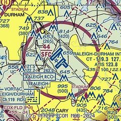
|
CAUTION: Diagram may not be current
 Download PDF
of official airport diagram from the FAA
| Airport distance calculator |
|---|
|
|
| Sunrise and sunset |
|---|
|
Times for 27-May-2026
| | Local
(UTC-4) | | Zulu
(UTC) |
|---|
| Morning civil twilight | | 05:34 | | 09:34 |
| Sunrise | | 06:03 | | 10:03 |
| Sunset | | 20:22 | | 00:22 |
| Evening civil twilight | | 20:51 | | 00:51 |
|
| Current date and time |
|---|
| Zulu (UTC) | 27-May-2026 23:29:53 |
|---|
| Local (UTC-4) | 27-May-2026 19:29:53 |
|---|
|
| METAR |
|---|
| KRDU | 272251Z 21014KT 10SM FEW035TCU FEW120 BKN250 30/22 A2993 RMK AO2 SLP130 CB SW MOV E AND DSNT W-NE TCU SE T03000217
|
|
| TAF |
|---|
| KRDU | 271727Z 2718/2818 24010G17KT P6SM SCT025 BKN035 BKN090 FM271900 24012G19KT P6SM BKN035 BKN090 TEMPO 2722/2802 2SM SHRA BR BKN025 BKN150 FM280200 25004KT P6SM FEW020 BKN040 BKN150 TEMPO 2802/2806 BKN020 FM281300 32008KT P6SM SCT040 BKN090
|
|
| NOTAMs |
|---|
NOTAMs are issued by the DoD/FAA and will open in a separate window not controlled by AirNav.
|
|


