FAA INFORMATION EFFECTIVE 14 MAY 2026
Location
| FAA Identifier: | SET |
| Lat/Long: | 38-55-46.9000N 090-25-47.9000W
38-55.781667N 090-25.798333W
38.9296944,-90.4299722
(estimated) |
| Elevation: | 436.7 ft. / 133.1 m (surveyed) |
| Variation: | 01E (1995) |
| From city: | 9 miles NE of ST CHARLES, MO |
| Time zone: | UTC -5 (UTC -6 during Standard Time) |
| Zip code: | 63373 |
Airport Operations
| Airport use: | Open to the public |
| Activation date: | 05/1941 |
| Control tower: | no |
| ARTCC: | KANSAS CITY CENTER |
| FSS: | SAINT LOUIS FLIGHT SERVICE STATION |
| NOTAMs facility: | SET (NOTAM-D service available) |
| Attendance: | APR-OCT 0730-1630 DUSK, NOV-MAR 0730-1630 |
| Wind indicator: | lighted |
| Segmented circle: | yes |
| Lights: | ACTVT MIRL RWY 18/36 AND RWY 09/27 & REIL RWY 18, PAPI RWY 18 - CTAF. DUSK TO DAWN ONLY. |
| Beacon: | white-green (lighted land airport)
Operates sunset to sunrise. |
Airport Communications
| CTAF/UNICOM: | 122.7 |
| WX ASOS: | 118.075 (636-250-4590) |
| SAINT LOUIS APPROACH: | 124.2 [OPR 1300-0500Z++ MON-FRI; 1400-2300Z++ SAT-SUN; CLSD HOL.] |
| SAINT LOUIS DEPARTURE: | 124.2 [OPR 1300-0500Z++ MON-FRI; 1400-2300Z++ SAT-SUN; CLSD HOL.] |
| CLEARANCE DELIVERY: | 121.6 |
| WX ASOS at STL (11 nm S): | PHONE 314-238-8419 |
| WX AWOS-3PT at ALN (18 nm E): | 128.0 (618-259-7231) |
| WX ASOS at SUS (19 nm SW): | 134.8 (314-890-7255) |
Nearby radio navigation aids
| VOR radial/distance | | VOR name | | Freq | | Var |
|---|
| STLr030/4.8 | | ST LOUIS VORTAC | | 117.40 | | 01E |
| TOYr292/26.5 | | TROY VORTAC | | 116.00 | | 04E |
| FTZr056/29.0 | | FORISTELL VORTAC | | 114.35 | | 05E |
Airport Services
| Fuel available: | 100LL |
| Parking: | hangars and tiedowns |
| Airframe service: | MAJOR |
| Powerplant service: | MAJOR |
| Bottled oxygen: | NONE |
| Bulk oxygen: | NONE |
Runway Information
Runway 18/36
| Dimensions: | 3800 x 75 ft. / 1158 x 23 m |
| Surface: | asphalt, in fair condition |
| Weight bearing capacity: | |
| Runway edge lights: | medium intensity |
| RUNWAY 18 | | RUNWAY 36 |
| Latitude: | 38-56.010505N | | 38-55.384538N |
| Longitude: | 090-25.849568W | | 090-25.859158W |
| Elevation: | 432.9 ft. | | 436.4 ft. |
| Traffic pattern: | left | | left |
| Runway heading: | 180 magnetic, 181 true | | 000 magnetic, 001 true |
| Markings: | nonprecision, in good condition | | nonprecision, in fair condition |
| Visual slope indicator: | 4-light PAPI on left (3.00 degrees glide path) | | 4-box VASI on left
RWY 36 VASI OUT OF SERVICE INDEFINITELY |
| Runway end identifier lights: | yes | | |
| Touchdown point: | yes, no lights | | yes, no lights |
Runway 9/27
| Dimensions: | 2000 x 75 ft. / 610 x 23 m |
| Surface: | asphalt, in good condition |
| Weight bearing capacity: | |
| Runway edge lights: | medium intensity |
| RUNWAY 9 | | RUNWAY 27 |
| Latitude: | 38-55.942975N | | 38-55.938820N |
| Longitude: | 090-25.900885W | | 090-25.479025W |
| Elevation: | 433.9 ft. | | 435.6 ft. |
| Traffic pattern: | left | | left |
| Runway heading: | 090 magnetic, 091 true | | 270 magnetic, 271 true |
| Markings: | basic, in good condition | | basic, in good condition |
| Touchdown point: | yes, no lights | | yes, no lights |
Airport Ownership and Management from official FAA records
| Ownership: | Publicly-owned |
| Owner: | ST CHARLES COUNTY
201 N. 2ND ST.
ST CHARLES, MO 63301
Phone 636-949-7500 |
| Manager: | DENNIS WISS
6390 GRAFTON FERRY RD
PORTAGE DES SIOUX, MO 63373
Phone 636-949-1893 |
Additional Remarks
| - | HEAVY STUDENT TRNG. |
| - | ARPT CONDS NOT REPORTED MON-FRI 1630L-0800L DLY, FRI 1630L THRU MON 0800L. |
| - | FOR CD CTC ST LOUIS APCH AT 314-890-1017. |
Instrument Procedures
NOTE: All procedures below are presented as PDF files. If you need a reader for these files, you should download the free Adobe Reader.NOT FOR NAVIGATION. Please procure official charts for flight.
FAA instrument procedures published for use from 14 May 2026 at 0901Z to 11 June 2026 at 0900Z.
IAPs - Instrument Approach Procedures |
|---|
| RNAV (GPS) RWY 18 | |
download (229KB) |
| NOTE: Special Alternate Minimums apply **CHANGED** | |
download (147KB) |
| NOTE: Special Take-Off Minimums/Departure Procedures apply | |
download (432KB) |
Other nearby airports with instrument procedures:
KSTL - St Louis Lambert International Airport (11 nm S)
1H0 - Creve Coeur Airport (13 nm S)
KALN - St Louis Regional Airport (18 nm E)
KSUS - Spirit of St Louis Airport (19 nm SW)
KCPS - St Louis Downtown Airport (25 nm SE)
|
|

Road maps at:
MapQuest
Bing
Google
| Aerial photo |
|---|
WARNING: Photo may not be current or correct

Do you have a better or more recent aerial photo of St Charles County Regional Airport/Smartt Field that you would like to share? If so, please send us your photo.
|
| Sectional chart |
|---|
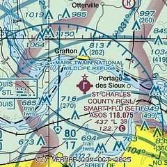
|
| Airport distance calculator |
|---|
|
|
| Sunrise and sunset |
|---|
|
Times for 27-May-2026
| | Local
(UTC-5) | | Zulu
(UTC) |
|---|
| Morning civil twilight | | 05:10 | | 10:10 |
| Sunrise | | 05:41 | | 10:41 |
| Sunset | | 20:16 | | 01:16 |
| Evening civil twilight | | 20:47 | | 01:47 |
|
| Current date and time |
|---|
| Zulu (UTC) | 28-May-2026 03:40:38 |
|---|
| Local (UTC-5) | 27-May-2026 22:40:38 |
|---|
|
| METAR |
|---|
| KSET | 280254Z AUTO 03003KT 10SM CLR 22/19 A2998 RMK AO2 SLP146 T02170194 53012
|
KSTL
11nm S | 280251Z 08004KT 10SM BKN250 24/18 A2999 RMK AO2 SLP145 T02390178 53009 $
|
KALN
19nm E | 280315Z AUTO 00000KT 10SM CLR 21/19 A3001 RMK AO2 T02090190 TSNO
|
KSUS
20nm SW | 280254Z 26003KT 10SM CLR 21/18 A2997 RMK AO2 SLP143 T02060183 53010
|
|
| TAF |
|---|
KSTL
11nm S | 272059Z 2721/2824 03005KT P6SM VCSH BKN050 FM272300 03005KT P6SM SCT090 FM280200 VRB03KT P6SM FEW070 SCT250 FM281500 07008KT P6SM FEW060 BKN150
|
KSUS
20nm SW | 271729Z 2718/2818 VRB05KT P6SM BKN040 FM280200 00000KT P6SM FEW070 SCT250 TEMPO 2809/2813 3SM BR FEW250 FM281500 07008KT P6SM FEW060 BKN150
|
|
| NOTAMs |
|---|
NOTAMs are issued by the DoD/FAA and will open in a separate window not controlled by AirNav.
|
|

