FAA INFORMATION EFFECTIVE 16 APRIL 2026
Location
| FAA Identifier: | TIK |
| Lat/Long: | 35-24-53.1000N 097-23-11.9000W
35-24.885000N 097-23.198333W
35.4147500,-97.3866389
(estimated) |
| Elevation: | 1290.6 ft. / 393.4 m (surveyed) |
| Variation: | 03E (2020) |
| From city: | 8 miles SE of OKLAHOMA CITY, OK |
| Time zone: | UTC -5 (UTC -6 during Standard Time) |
| Zip code: | 73145 |
Airport Operations
| Airport use: | Private use. Permission required prior to landing |
| Activation date: | 07/1943 |
| Control tower: | yes |
| ARTCC: | FORT WORTH CENTER |
| FSS: | MC ALESTER FLIGHT SERVICE STATION |
| NOTAMs facility: | MLC (NOTAM-D service available) |
| Attendance: | CONTINUOUS |
| Pattern altitude: | RECTANGULAR AND CLSD TFC PAT 3000 FT (INCL FTR/TRAINER ACFT), OVHD TFC PAT O/R 3500 FT. |
| Wind indicator: | yes |
| Segmented circle: | no |
| Lights: | SS-SR |
| Beacon: | white-green (lighted land airport)
Operates sunset to sunrise. |
Airport Communications
| ATIS: | 270.1 |
| TINKER GROUND: | 121.8 275.8 |
| TINKER TOWER: | 124.45 251.05 |
| OKE CITY APPROACH: | 120.45 ;081-170 124.2 ;001-080 124.6 ;261-360 126.65 ;171-260 |
| OKE CITY DEPARTURE: | 120.45 ;081-170 124.2 ;001-080 124.6 ;261-360 126.65 ;171-260 |
| CLEARANCE DELIVERY: | 119.7 335.8 |
| AFMC: | 382.6 |
| AMC/ATOC: | 119.15 |
| BASTS RNAV STAR: | 124.6 |
| CCASH RNAV STAR: | 124.6 |
| CLASS C: | 120.45 ;081-170 124.2 ;001-080 124.6 ;261-360 126.65 ;171-260 |
| COMD POST: | 139.95 ;ARROW CTL 141.65 ;CALL RAYMOND 24 225.875 ;CALL RAYMOND 24 305.6 ;CALL RAYMOND 24 |
| DAWKS RNAV STAR: | 124.6 |
| EMERG: | 121.5 243.0 |
| FAKEY RNAV STAR: | 124.6 |
| IC: | 124.6 ;261-360 |
| JUDDG RNAV STAR: | 124.2 |
| OPS: | 228.45 ;507 ARW |
| PMSV METRO: | 261.025 |
| PTD: | 134.1 372.2 |
| SFA: | 354.125 |
| WAYMAN RNAV STAR: | 124.2 |
| WX ASOS at OKC (11 nm W): | PHONE 405-674-4013 |
| WX AWOS-3PT at OUN (11 nm S): | 119.55 (405-325-7302) |
| WX ASOS at PWA (15 nm NW): | PHONE 405-798-2013 |
| WX AWOS-3 at HSD (19 nm NW): | 120.975 (405-283-9848) |
- PMSV METRO: FCST SVC AVBL DUR AFLD OPR HR.
- AFMC FLT TEST: OC-ALC PDM INPUT ACFT CTC SABRE CONTROL 30 MIN PRIOR ARR.
- PMSV METRO - REMARKS: DSN 884-3196, C405-734-3196, ALTN WX LCTN DSN 884-3529, C405-734-3529.
- (ATIS PHONE NR) C405-734-5152.
- 354.125 CTC OKE CITY APP.
Nearby radio navigation aids
| VOR radial/distance | | VOR name | | Freq | | Var |
|---|
| IRWr066/11.4 | | WILL ROGERS VORTAC | | 114.10 | | 07E |
| PWAr111/14.6 | | WILEY POST VOR/DME | | 113.40 | | 08E |
Airport Services
| Parking: | hangars |
| Airframe service: | MAJOR |
| Powerplant service: | MAJOR |
| Bottled oxygen: | LOW |
| Bulk oxygen: | HIGH/LOW |
Runway Information
Runway 18/36
| Dimensions: | 11100 x 200 ft. / 3383 x 61 m |
| Surface: | PEM |
| Weight bearing capacity: | |
| Runway edge lights: | high intensity |
| RUNWAY 18 | | RUNWAY 36 |
| Latitude: | 35-25.740133N | | 35-23.910350N |
| Longitude: | 097-22.925833W | | 097-22.927900W |
| Elevation: | 1260.3 ft. | | 1290.6 ft. |
| Traffic pattern: | left | | right |
| Runway heading: | 177 magnetic, 180 true | | 357 magnetic, 360 true |
| Markings: | precision, in good condition | | precision, in good condition |
| Visual slope indicator: | 4-light PAPI on left (2.80 degrees glide path) | | 4-light PAPI on left (2.60 degrees glide path) |
| RVR equipment: | touchdown | | touchdown |
| Approach lights: | SALSF | | ALSF1: standard 2,400 foot high intensity approach lighting system with centerline sequenced flashers (category I) |
| Runway end identifier lights: | no | | no |
| Touchdown point: | yes, no lights | | yes, no lights |
| Instrument approach: | ILS | | ILS |
Runway 13/31
| Dimensions: | 10000 x 200 ft. / 3048 x 61 m |
| Surface: | PEM |
| Weight bearing capacity: | |
| Runway edge lights: | high intensity |
| RUNWAY 13 | | RUNWAY 31 |
| Latitude: | 35-25.491183N | | 35-24.408800N |
| Longitude: | 097-24.258450W | | 097-22.739717W |
| Elevation: | 1227.2 ft. | | 1276.4 ft. |
| Traffic pattern: | right | | left |
| Runway heading: | 128 magnetic, 131 true | | 308 magnetic, 311 true |
| Markings: | NSTD, in good condition | | NSTD, in good condition |
| Visual slope indicator: | 4-light PAPI on left (2.80 degrees glide path) | | 4-light PAPI on left (3.00 degrees glide path) |
| Approach lights: | SALS | | SALS |
| Touchdown point: | yes, no lights | | yes, no lights |
| Instrument approach: | LOCALIZER | | LOCALIZER |
Airport Ownership and Management from official FAA records
| Ownership: | U.S. Air Force |
| Owner: | U.S. AIR FORCE
2854TH AIR BASE GP(AFLC)
TINKER AFB,OK.CITY, OK 73145 |
| Manager: | CHIEF AIRFIELD MANAGEMENT
2854TH AIR BASE GP(AFLC)
TINKER AFB OK. CITY, OK 73145
Phone 405-732-1110 |
Additional Remarks
| - | NS ABTMT: PRACTICE CIR APCH TO RWY 18 PROH. NGT QUIET HR IN EFF 0500-1200Z++, PRACTICE APCH ARE RSTD. |
| - | TFC PAT: USE 124.45 WHILE IN TFC PAT, MNT 251.05 TO MAX EXTENT POSSIBLE. |
| - | SERVICE-LGT: ALS RWY 18 NSTD FOR CAT I ILS. ALS RWY 13-31 NSTD. |
| - | CAUTION: UNLGTD BLDGS NW, W, SW AND E OF RWY 18-36. |
| - | JASU: 1(MC-1A) 1(MC-2A) 10(A/M32A-86) 6(AM32A-95) 8(AM32A-60). |
| - | CAUTION: EXER CTN WHILE TAX; PORTIONS OF ALC RAMP, KC-46 RAMP, AND MUNITIONS FAC NOT VIS FM TWR. . HOLD SHORT OF RAMP FOR INDIVIDUAL ACFT FLW-ME ASSISTANCE. |
| - | FLUID: PRESAIR LHOX LOX LHNIT. |
| - | OIL: 7808, 23699 HYD FLUID-5606, 83282 SOAP-RESULTS AVBL 1345-1730Z++, 1830-0600Z++ WKD EXC HOL, RESULTS NOT AVBL OT. |
| - | TRAN ALERT: OPR 1400-0530Z++. LTD FLEET SVC (LAVATORY AND WATER ONLY). |
| - | SEE FLIP AP/1 SUPPLEMENTARY ARPT RMK. |
| - | CAUTION: UNLGTD SECURITY FENCES SURROUND AIRFIELD. |
| - | CSTMS/AG/IMG: SEE FCG KTIK ENTRY. |
| - | SERVICE-FUEL: A++(MIL). |
| - | RSTD: PPR TRAN ACFT, CTC BASE OPS DSN 884-2191, C405-734-2191. NOTIFY BASE OPS OF 1 HR OR MORE ETA CHG AND PPR CNL. NO TRAN ACFT ARR/DEP 0530-1400Z++. TRAN ACFT MAY EXP ONLY ONE APCH DUR PERIODS OF INTS LCL TRNG. |
| - | MISC: VIP ACFT CTC BASE OPS 30 MIN PRIOR TO ETA WITH FIRM CHOCK TIME. RWY 13-31 APCH ENDS 1000' CONC; REMAINING RWY KEEL 75' CONC; NON-KEEL ASPHALT. RWY 18-36 APCH ENDS 1000' CONC, REMAINING RWY KEEL 75' CONC, NON-KEEL ASPHALT; MID 8100' RWY GROOVED. TWY A CLSD E SIDE RWY 18-36. TWY M NSTD DUE TO 50 WIDE. TWY C NSTD SHOULDERS BTN TRIM PAD AND RWY 13-31.HGR SPACE FOR TRAN ACFT DUR INCLEMENT WX EXTREMELY LTD. TRAN SVC FOR B52, B1, C5, C17, C130, KC10 AND C135 EXTREMELY LTD, ACFT SHOULD HAVE CREW CHIEF ON BOARD. |
| - | MISC: ANTI-ICING/DE-ICING CAPABILITIES FOR TRAN ACFT LIMITED, TRAN AIRCREWS MUST CTC BASE OPS WITH DEICING REQ PRIOR TO ARRIVAL.RWY COND CODE(RWYCC) AND FIELD CONDITION NOTAM (FICON) NOT DETERMINED/RPRTD. AIR TERMINAL SVC (ATOC) AND CONTINGENCY/DEPLOYMENT OPR AVBL 1300-0100Z++ DLY. ACFT LOADING/OFFLOADING REQ OUTSIDE PUBL TIMES CTC DSN 339-5553, C405-734-2751. STD USAF RSRS APPLIED. |
| - | CAUTION: N/S VFR CORRIDOR SFC - 3000' 1 NM OFF DEP END RWY 31. |
Instrument Procedures
NOTE: All procedures below are presented as PDF files. If you need a reader for these files, you should download the free Adobe Reader.NOT FOR NAVIGATION. Please procure official charts for flight.
FAA instrument procedures published for use from 16 April 2026 at 0901Z to 14 May 2026 at 0900Z.
STARs - Standard Terminal Arrivals |
|---|
| BASTS ONE (RNAV) | |
download (175KB) |
| CCASH ONE (RNAV) | |
download (177KB) |
| DAWKS ONE (RNAV) | |
download (178KB) |
| FAKEY ONE (RNAV) | |
download (114KB) |
| GULLI THREE | |
2 pages:
[1] [2] (336KB) |
| JUDDG TWO (RNAV) | |
download (249KB) |
| WAYMN ONE (RNAV) | |
download (185KB) |
IAPs - Instrument Approach Procedures |
|---|
| HI-ILS OR LOC/DME Y RWY 18 | |
download (151KB) |
| HI-ILS OR LOC/DME Y RWY 36 | |
download (143KB) |
| ILS OR LOC/DME Z RWY 18 | |
download (145KB) |
| ILS OR LOC/DME Z RWY 36 | |
download (134KB) |
| RNAV (GPS) RWY 18 | |
download (74KB) |
| RNAV (GPS) RWY 36 | |
download (74KB) |
| LOC/DME RWY 31 | |
download (140KB) |
| LOC RWY 13 | |
download (137KB) |
| HI-TACAN Y RWY 18 | |
download (145KB) |
| HI-TACAN Y RWY 36 | |
download (132KB) |
| TACAN Z RWY 18 | |
download (138KB) |
| TACAN Z RWY 36 | |
download (136KB) |
| Radar Approach Procedures available | |
download (186KB) |
| NOTE: Special Take-Off Minimums/Departure Procedures apply | |
download (391KB) |
Other nearby airports with instrument procedures:
KOKC - OKC Will Rogers International Airport (11 nm W)
KOUN - University of Oklahoma Westheimer Airport (11 nm S)
KPWA - Wiley Post Airport (15 nm NW)
1K4 - David Jay Perry Airport (16 nm S)
KHSD - Sundance Airport (19 nm NW)
|
|

Road maps at:
MapQuest
Bing
Google
| Aerial photo |
|---|
WARNING: Photo may not be current or correct
 Photo taken 16-Feb-2014
looking south.
Photo taken 16-Feb-2014
looking south.
Do you have a better or more recent aerial photo of Tinker Air Force Base that you would like to share? If so, please send us your photo.
|
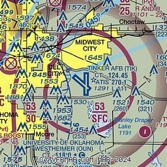
| Sectional chart |
|---|
|
 Download PDF
of official airport diagram from the FAA
| Airport distance calculator |
|---|
|
|
| Sunrise and sunset |
|---|
|
Times for 06-May-2026
| | Local
(UTC-5) | | Zulu
(UTC) |
|---|
| Morning civil twilight | | 06:06 | | 11:06 |
| Sunrise | | 06:34 | | 11:34 |
| Sunset | | 20:19 | | 01:19 |
| Evening civil twilight | | 20:46 | | 01:46 |
|
| Current date and time |
|---|
| Zulu (UTC) | 06-May-2026 19:32:23 |
|---|
| Local (UTC-5) | 06-May-2026 14:32:23 |
|---|
|
| METAR |
|---|
| KTIK | 061855Z AUTO 04007G19KT 10SM CLR 18/05 A3000 RMK AO2 SLP158 T01750051 $
|
KOKC
11nm W | 061852Z 02014G21KT 10SM SCT045 SCT150 SCT250 17/05 A3002 RMK AO2 SLP160 T01720050
|
KOUN
12nm S | 061845Z 07012KT 10SM CLR 16/05 A3000
|
KPWA
15nm NW | 061853Z 04010G17KT 10SM OVC043 16/04 A3002 RMK AO2 SLP163 T01610044
|
KHSD
19nm NW | 061915Z AUTO 03010KT 10SM OVC043 16/05 A3003 RMK A01
|
|
| TAF |
|---|
| KTIK | 061700Z 0617/0723 02012G20KT 9999 SCT030 QNH2995INS BECMG 0621/0622 02012KT 9999 BKN050 BKN075 QNH2997INS TX16/0621Z TN09/0712Z
|
KOKC
11nm W | 061720Z 0618/0718 05013G21KT P6SM BKN035 FM070100 01007KT P6SM BKN050 FM071500 28007KT P6SM BKN250
|
KOUN
12nm S | 061720Z 0618/0718 04013G18KT P6SM BKN035 FM070000 01006KT P6SM BKN050 FM071500 28007KT P6SM BKN250
|
|
| NOTAMs |
|---|
NOTAMs are issued by the DoD/FAA and will open in a separate window not controlled by AirNav.
|
|


