FAA INFORMATION EFFECTIVE 10 JULY 2025
Location
| FAA Identifier: | TUL |
| Lat/Long: | 36-11-54.2160N 095-53-17.1790W
36-11.903600N 095-53.286317W
36.1983933,-95.8881053
(estimated) |
| Elevation: | 677.8 ft. / 206.6 m (surveyed) |
| Variation: | 03E (2020) |
| From city: | 5 miles NE of TULSA, OK |
| Time zone: | UTC -5 (UTC -6 during Standard Time) |
| Zip code: | 74115 |
Airport Operations
| Airport use: | Open to the public |
| Activation date: | 08/1942 |
| Control tower: | yes |
| ARTCC: | KANSAS CITY CENTER |
| FSS: | MC ALESTER FLIGHT SERVICE STATION |
| NOTAMs facility: | TUL (NOTAM-D service available) |
| Attendance: | CONTINUOUS |
| Wind indicator: | lighted |
| Segmented circle: | no |
| Lights: | SS-SR |
| Beacon: | white-green (lighted land airport)
Operates sunset to sunrise. |
| Fire and rescue: | ARFF index C |
| International operations: | customs landing rights airport |
Airport Communications
| UNICOM: | 122.95 |
| WX ASOS: | PHONE 539-399-0187 |
| TULSA GROUND: | 121.9 348.6 |
| TULSA TOWER: | 118.7 ;RWY 18R/36L 121.2 ;RWY 08/26, 18L/36R 257.8 ;RWY 18R/36L 310.8 ;RWY 08/26, 18L/36R |
| TULSA APPROACH: | 119.1 ;355-174 124.0 ;175-354 338.3 ;175-354 360.825 ;355-174 |
| TULSA DEPARTURE: | 119.1 ;355-174 124.0 ;175-354 338.3 ;175-354 360.825 ;355-174 |
| CLEARANCE DELIVERY: | 134.05 284.7 |
| PRE-TAXI CLEARANCE: | 134.05 284.7 |
| ANG OPS: | 335.475 381.1 |
| CLASS C: | 119.1 ;355-174 124.0 ;175-354 338.3 ;175-354 360.825 ;355-174 |
| D-ATIS: | 124.9 377.2 |
| EMERG: | 121.5 243.0 |
| FINAL: | 119.85 ;355-174 132.1 ;175-354 239.275 319.9 ;175-354 381.2 ;355-175 |
| IC: | 124.0 ;175-354 338.3 ;175-354 |
| NG OPS: | 46.9FM |
| PTD: | 260.4 |
| TULSA DP: | 124.0 338.3 |
| VINTA STAR: | 119.1 360.825 |
| WX ASOS at RVS (11 nm SW): | 126.5 (918-299-0740) |
| WX AWOS-3T at OWP (13 nm W): | 118.325 (918-246-2635) |
Nearby radio navigation aids
| VOR radial/distance | | VOR name | | Freq | | Var |
|---|
| TULr264/4.8 | | TULSA VORTAC | | 114.40 | | 08E |
| OKMr350/30.3 | | OKMULGEE VOR/DME | | 114.90 | | 08E |
| BVOr163/38.7 | | BARTLESVILLE VOR/DME | | 117.90 | | 08E |
| NDB name | | Hdg/Dist | | Freq | | Var | | ID |
|---|
| OILLR | | 357/6.1 | | 338 | | 03E | | TU | - ..- |
Airport Services
| Fuel available: | 100LL JET-A |
| Parking: | hangars and tiedowns |
| Airframe service: | MAJOR |
| Powerplant service: | MAJOR |
| Bottled oxygen: | HIGH/LOW |
| Bulk oxygen: | HIGH/LOW |
Runway Information
Runway 18L/36R
| Dimensions: | 10000 x 150 ft. / 3048 x 46 m |
| Surface: | concrete/grooved, in excellent condition |
| Weight bearing capacity: | | Single wheel: | 75.0 | | Double wheel: | 200.0 | | Double tandem: | 400.0 |
|
| Runway edge lights: | high intensity |
| RUNWAY 18L | | RUNWAY 36R |
| Latitude: | 36-12.836092N | | 36-11.190522N |
| Longitude: | 095-52.878657W | | 095-52.988070W |
| Elevation: | 626.6 ft. | | 643.8 ft. |
| Traffic pattern: | left | | right |
| Runway heading: | 180 magnetic, 183 true | | 000 magnetic, 003 true |
| Declared distances: | TORA:10000 TODA:10000 ASDA:10000 LDA:10000 | | TORA:10000 TODA:10000 ASDA:10000 LDA:10000 |
| Markings: | precision, in good condition | | precision, in good condition |
| Visual slope indicator: | 4-light PAPI on left (2.75 degrees glide path) | | 4-light PAPI on left (3.00 degrees glide path) |
| RVR equipment: | touchdown, midfield, rollout | | touchdown, midfield, rollout |
| Approach lights: | MALSR: 1,400 foot medium intensity approach lighting system with runway alignment indicator lights | | ALSF2: standard 2,400 foot high intensity approach lighting system with centerline sequenced flashers (category II or III) |
| Centerline lights: | yes | | yes |
| Touchdown point: | yes, no lights | | yes, lighted |
| Instrument approach: | ILS/DME | | ILS/DME |
| Obstructions: | 41 ft. tree, 1894 ft. from runway, 471 ft. of centerline, 41:1 slope to clear | | 29 ft. tree, 1593 ft. from runway, 127 ft. right of centerline, 48:1 slope to clear |
Runway 8/26
| Dimensions: | 7376 x 150 ft. / 2248 x 46 m |
| Surface: | concrete/grooved, in fair condition |
| Weight bearing capacity: | | Single wheel: | 75.0 | | Double wheel: | 200.0 | | Double tandem: | 350.0 |
|
| Runway edge lights: | high intensity |
| RUNWAY 8 | | RUNWAY 26 |
| Latitude: | 36-11.725905N | | 36-11.738013N |
| Longitude: | 095-53.941832W | | 095-52.442210W |
| Elevation: | 671.2 ft. | | 633.0 ft. |
| Traffic pattern: | left | | left |
| Runway heading: | 086 magnetic, 089 true | | 266 magnetic, 269 true |
| Declared distances: | TORA:7376 TODA:7376 ASDA:7376 LDA:7376 | | TORA:7376 TODA:7376 ASDA:7376 LDA:7376 |
| Markings: | nonprecision, in good condition | | nonprecision, in good condition |
| Visual slope indicator: | 4-light PAPI on left (3.00 degrees glide path)
PAPI UNUSBL BYD 8 DEGS LEFT & RIGHT OF RWY CNTRLN. | | 4-light PAPI on left (3.00 degrees glide path)
PAPI UNUSBL BYD 7 DEGS RIGHT & 9 DEGS LEFT OF CNTRLN. |
| Approach lights: | | | MALSR: 1,400 foot medium intensity approach lighting system with runway alignment indicator lights |
| Runway end identifier lights: | yes | | no |
| Touchdown point: | yes, no lights | | yes, no lights |
| Obstructions: | 36 ft. tree, 1775 ft. from runway, 430 ft. right of centerline, 43:1 slope to clear | | none |
Runway 18R/36L
| Dimensions: | 6101 x 100 ft. / 1860 x 30 m |
| Surface: | asphalt/grooved, in good condition |
| Weight bearing capacity: | | Single wheel: | 100.0 | | Double wheel: | 140.0 |
|
| Runway edge lights: | high intensity |
| RUNWAY 18R | | RUNWAY 36L |
| Latitude: | 36-12.433200N | | 36-11.429263N |
| Longitude: | 095-53.945410W | | 095-54.012225W |
| Elevation: | 634.9 ft. | | 677.2 ft. |
| Traffic pattern: | right | | left |
| Runway heading: | 180 magnetic, 183 true | | 000 magnetic, 003 true |
| Displaced threshold: | 600 ft. | | no |
| Declared distances: | TORA:6101 TODA:6101 ASDA:5741 LDA:5141 | | TORA:6101 TODA:6101 ASDA:5101 LDA:5101 |
| Markings: | precision, in good condition | | nonprecision, in good condition |
| Visual slope indicator: | 4-light PAPI on left (2.75 degrees glide path) | | 4-light PAPI on left (3.00 degrees glide path) |
| Runway end identifier lights: | yes | | yes |
| Touchdown point: | yes, no lights | | yes, no lights |
| Instrument approach: | ILS | | |
| Obstructions: | none | | 10 ft. road, 200 ft. from runway, 419 ft. left of centerline, 1:1 slope to clear |
Airport Ownership and Management from official FAA records
| Ownership: | Publicly-owned |
| Owner: | CITY OF TULSA
TULSA ARPT AUTH. BOX 581838
TULSA, OK 74158
Phone 918-838-5000 |
| Manager: | ALEXIS HIGGINS
PO BOX 581838
TULSA, OK 74158
Phone 918-838-5000 |
Additional Remarks
| A39-18R/36L | PCR VALUE: 427/F/D/X/T |
| A39-18L/36R | PCR VALUE: 1175/R/C/W/T |
| A39-08/26 | PCR VALUE: 626/R/B/W/T |
| A30A-18R | IREG WIND PAT. |
| E60-36R | BAK-14 BAK-12A(B) (1500 FT). |
| E60-08 | BAK-14 BAK-12A(B) (1500 FT). |
| E60-26 | BAK-14 BAK-12A(B) (1500 FT). |
| E60-18L | BAK-14 BAK-12A(B) (1500 FT). |
| - | CTN: 4000 FT BLACKTOP TRACK 1.5 NM E RWY 26; DO NOT MISTAKE FOR RWY. |
| - | TXLS LA, LB, NN & QQ NOT VSB FM ATCT. |
| - | BIRDS ON & INVOF ARPT. |
| - | APVD ACFT RUN UP AREA: 2300-0600 N END TWY J ACFT ORIENTATION N & S. 24 HR APCH END RWY 26 ACFT ORIENTATION E & W. 0600-2300 N END TWY L ACFT ORIENTATION N & S. |
| - | TWY L SOUTH OF TWY L3 NOT VSB TO ATCT. |
| - | TXL LB NOT VSB TO ATCT. |
| - | WT RSTRD AREAS: TWY JJ S-35; TWY M2 S-81/D-140/DT-186; TWY HH S-55/D-60; TWY L NORTH OF RWY 08/26 S-93/D-140/DT 209; TWY L BTN TWY C & TWY L2 S-120/D-250/DT 372; TWY L2 S-70/D-100/DT-166. |
| - | NOISE ABATEMENT ALL RWYS: CLIMB TO 3000 FT ASAP AFT TKOF. |
Instrument Procedures
NOTE: All procedures below are presented as PDF files. If you need a reader for these files, you should download the free Adobe Reader.NOT FOR NAVIGATION. Please procure official charts for flight.
FAA instrument procedures published for use from 10 July 2025 at 0901Z to 07 August 2025 at 0900z.
STARs - Standard Terminal Arrivals |
|---|
| VINTA THREE | |
download (174KB) |
IAPs - Instrument Approach Procedures |
|---|
| ILS OR LOC RWY 18L | |
download (390KB) |
| ILS OR LOC RWY 18R | |
download (274KB) |
| ILS OR LOC RWY 36R | |
download (431KB) |
| ILS RWY 36R (SA CAT I) | |
download (365KB) |
| ILS RWY 36R (CAT II) | |
download (349KB) |
| RNAV (GPS) RWY 08 | |
download (287KB) |
| RNAV (GPS) RWY 18L | |
download (326KB) |
| RNAV (GPS) RWY 18R | |
download (299KB) |
| RNAV (GPS) RWY 26 | |
download (303KB) |
| RNAV (GPS) RWY 36L | |
download (307KB) |
| RNAV (GPS) RWY 36R | |
download (311KB) |
| VOR/DME RWY 08 | |
download (282KB) |
| HI-VOR Z OR TACAN Z RWY 26 | |
download (175KB) |
| VOR Y OR TACAN Y RWY 26 | |
download (295KB) |
| Radar Approach Procedures available | |
download (159KB) |
| NOTE: Special Alternate Minimums apply | |
download (144KB) |
Departure Procedures |
|---|
| TULSA ONE | |
download (224KB) |
| NOTE: Special Take-Off Minimums/Departure Procedures apply | |
download (452KB) |
Other nearby airports with instrument procedures:
KRVS - Tulsa Riverside Airport (11 nm SW)
KOWP - William R Pogue Municipal Airport (13 nm W)
KGCM - Claremore Regional Airport (21 nm E)
H71 - Mid-America Industrial Airport (27 nm E)
H68 - Hefner-Easley Airport (30 nm SE)
|
|

Road maps at:
MapQuest
Bing
Google
| Aerial photo |
|---|
WARNING: Photo may not be current or correct
 Photo by Germaine and Matt
Taken in May 2018
looking north (from 3000ft).
Photo by Germaine and Matt
Taken in May 2018
looking north (from 3000ft).
Do you have a better or more recent aerial photo of Tulsa International Airport that you would like to share? If so, please send us your photo.
|
| Sectional chart |
|---|
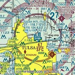
|
CAUTION: Diagram may not be current
 Download PDF
of official airport diagram from the FAA
| Airport distance calculator |
|---|
|
|
| Sunrise and sunset |
|---|
|
Times for 05-Aug-2025
| | Local
(UTC-5) | | Zulu
(UTC) |
|---|
| Morning civil twilight | | 06:07 | | 11:07 |
| Sunrise | | 06:35 | | 11:35 |
| Sunset | | 20:24 | | 01:24 |
| Evening civil twilight | | 20:52 | | 01:52 |
|
| Current date and time |
|---|
| Zulu (UTC) | 05-Aug-2025 08:59:54 |
|---|
| Local (UTC-5) | 05-Aug-2025 03:59:54 |
|---|
|
| METAR |
|---|
| KTUL | 050853Z 31003KT 10SM FEW250 22/20 A3007 RMK AO2 SLP174 T02170200 56003
|
KRVS
10nm SW | 050853Z AUTO 00000KT 8SM CLR 21/21 A3006 RMK AO2 SLP181 T02110211 56002
|
KOWP
13nm W | 050835Z AUTO 00000KT 10SM CLR 22/19 A3010 RMK AO2 T02200190
|
|
| TAF |
|---|
| KTUL | 050522Z 0506/0606 08003KT P6SM SKC FM051500 15006KT P6SM SCT050 FM060100 14005KT P6SM SKC
|
KRVS
10nm SW | 050522Z 0506/0606 00000KT P6SM SKC FM051500 15005KT P6SM SCT050 FM060100 14003KT P6SM SKC
|
|
| NOTAMs |
|---|
NOTAMs are issued by the DoD/FAA and will open in a separate window not controlled by AirNav.
|
|


