FAA INFORMATION EFFECTIVE 27 NOVEMBER 2025
Location
| FAA Identifier: | LCH |
| Lat/Long: | 30-07-33.9400N 093-13-24.2860W
30-07.565667N 093-13.404767W
30.1260944,-93.2234128
(estimated) |
| Elevation: | 14.5 ft. / 4.4 m (surveyed) |
| Variation: | 03E (2005) |
| From city: | 5 miles S of LAKE CHARLES, LA |
| Time zone: | UTC -6 (UTC -5 during Daylight Saving Time) |
| Zip code: | 70607 |
Airport Operations
| Airport use: | Open to the public |
| Activation date: | 11/1961 |
| Control tower: | yes |
| ARTCC: | HOUSTON CENTER |
| FSS: | DE RIDDER FLIGHT SERVICE STATION |
| NOTAMs facility: | LCH (NOTAM-D service available) |
| Attendance: | 0500-2230 |
| Wind indicator: | lighted |
| Segmented circle: | yes |
| Lights: | WHEN ATCT CLSD ACTVT MALSR RWY 15; MALSF RWY 33; HIRL RWY 15/33; MIRL RWY 05/23 - CTAF. PAPI RWY 33 OPR CONSLY. |
| Beacon: | white-green (lighted land airport)
Operates sunset to sunrise. |
| Fire and rescue: | ARFF index B |
| International operations: | customs landing rights airport |
Airport Communications
| CTAF: | 120.7 |
| UNICOM: | 122.95 |
| ATIS: | 118.75 |
| WX ASOS: | PHONE 337-240-9596 |
| LAKE CHARLES GROUND: | 121.8 [0600-2200] |
| LAKE CHARLES TOWER: | 120.7 257.8 [0600-2200] |
| LAKE CHARLES APPROACH: | 119.35 ;WEST 119.8 ;EAST 282.3 ;EAST 353.75 ;WEST [0600-2200] |
| LAKE CHARLES DEPARTURE: | 119.35 ;WEST 119.8 ;EAST 282.3 ;EAST 353.75 ;WEST [0600-2200] |
| CLEARANCE DELIVERY: | 126.25 |
| EMERG: | 121.5 243.0 |
| HEL OPS: | 119.75 ;OFFSHORE HELICOPTER OPERATIO |
| IC: | 119.35 ;WEST 353.75 ;WEST |
| TRSA: | 119.35 ;WEST 119.8 ;EAST 282.3 ;EAST 353.75 ;WEST |
| WX AWOS-3 at CWF (7 nm NE): | 120.0 (337-214-2134) |
| WX AWOS-3PT at UXL (8 nm W): | 118.175 (337-558-5321) |
- APCH/DEP SVC PRVDD BY HOUSTON ARTCC (ZHU) ON FREQS 124.7/317.4 (LAKE CHARLES RCAG) WHEN LAKE CHARLES APCH CTL (LCH) CLSD.
Nearby radio navigation aids
| VOR radial/distance | | VOR name | | Freq | | Var |
|---|
| LCHr254/6.2 | | LAKE CHARLES VORTAC | | 113.40 | | 07E |
| NDB name | | Hdg/Dist | | Freq | | Var | | ID |
|---|
| MOSSY | | 187/10.9 | | 418 | | 00E | | CW | -.-. .-- |
| SULPHUR | | 109/11.1 | | 278 | | 04E | | AUR | .- ..- .-. |
Airport Services
| Fuel available: | 100LL JET-A1+ |
| Parking: | hangars and tiedowns |
| Airframe service: | MAJOR |
| Powerplant service: | MAJOR |
| Bottled oxygen: | NONE |
| Bulk oxygen: | NONE |
Runway Information
Runway 15/33
| Dimensions: | 6500 x 150 ft. / 1981 x 46 m |
| Surface: | concrete/grooved, in good condition
SOUTH 900 FT GRVD. |
| Weight bearing capacity: | | Single wheel: | 100.0 | | Double wheel: | 145.0 | | Double tandem: | 260.0 |
|
| Runway edge lights: | high intensity |
| RUNWAY 15 | | RUNWAY 33 |
| Latitude: | 30-07.723272N | | 30-06.753808N |
| Longitude: | 093-13.675235W | | 093-13.147895W |
| Elevation: | 11.2 ft. | | 9.8 ft. |
| Traffic pattern: | right | | left |
| Runway heading: | 152 magnetic, 155 true | | 332 magnetic, 335 true |
| Declared distances: | TORA:6500 TODA:6500 ASDA:6500 LDA:6500 | | TORA:6500 TODA:6500 ASDA:6500 LDA:6500 |
| Markings: | precision, in good condition | | precision, in good condition |
| Visual slope indicator: | 4-light PAPI on left (3.00 degrees glide path) | | 4-light PAPI on right (3.00 degrees glide path) |
| RVR equipment: | touchdown, midfield | | midfield |
| Approach lights: | MALSR: 1,400 foot medium intensity approach lighting system with runway alignment indicator lights | | MALSF: 1,400 foot medium intensity approach lighting system with sequenced flashers |
| Touchdown point: | yes, no lights | | yes, no lights |
| Instrument approach: | ILS/DME | | |
| Obstructions: | 28 ft. pole, 1412 ft. from runway, 421 ft. left of centerline, 46:1 slope to clear | | none |
Runway 5/23
| Dimensions: | 5200 x 100 ft. / 1585 x 30 m |
| Surface: | asphalt, in good condition |
| Weight bearing capacity: | | Single wheel: | 70.0 | | Double wheel: | 90.0 | | Double tandem: | 140.0 |
|
| Runway edge lights: | medium intensity |
| RUNWAY 5 | | RUNWAY 23 |
| Latitude: | 30-07.709945N | | 30-08.239203N |
| Longitude: | 093-13.784657W | | 093-13.007867W |
| Elevation: | 10.1 ft. | | 14.5 ft. |
| Traffic pattern: | left | | right |
| Runway heading: | 049 magnetic, 052 true | | 229 magnetic, 232 true |
| Declared distances: | TORA:5200 TODA:5200 ASDA:5200 LDA:5200 | | TORA:5200 TODA:5200 ASDA:5200 LDA:5200 |
| Markings: | nonprecision, in fair condition | | nonprecision, in fair condition |
| Visual slope indicator: | 4-light PAPI on left (3.00 degrees glide path) | | 4-box VASI on left (3.00 degrees glide path) |
| Runway end identifier lights: | yes | | yes |
| Touchdown point: | yes, no lights | | yes, no lights |
| Obstructions: | 65 ft. tree, 1620 ft. from runway, 455 ft. right of centerline, 21:1 slope to clear | | none |
Airport Ownership and Management from official FAA records
| Ownership: | Publicly-owned |
| Owner: | CALCASIEU PARISH
PO BOX 5820
LAKE CHARLES, LA 70607
Phone 337-477-6051 |
| Manager: | HEATH ALLEN
PO DRAWER 5820
LAKE CHARLES, LA 70607-5820
Phone 337-477-6051 |
Additional Remarks
| A39-05/23 | PCR VALUE: 89/F/D/X/T |
| A39-15/33 | PCR VALUE: 287/R/D/X/T |
| - | ATCT BLIND SPOT ON TWY J. |
| - | BIRDS ON & INVOF ARPT. |
| - | FOR CD IF UNA TO CTC ON FSS FREQ, CTC HOUSTON ARTCC AT 281-230-5622. |
Instrument Procedures
NOTE: All procedures below are presented as PDF files. If you need a reader for these files, you should download the free Adobe Reader.NOT FOR NAVIGATION. Please procure official charts for flight.
FAA instrument procedures published for use from 27 November 2025 at 0901Z to 25 December 2025 at 0900Z.
IAPs - Instrument Approach Procedures |
|---|
| ILS OR LOC RWY 15 | |
download (275KB) |
| RNAV (GPS) RWY 05 | |
download (222KB) |
| RNAV (GPS) RWY 15 | |
download (229KB) |
| RNAV (GPS) RWY 23 | |
download (225KB) |
| RNAV (GPS) RWY 33 | |
download (228KB) |
| VOR-A | |
download (183KB) |
| VOR-B | |
download (185KB) |
| Radar Approach Procedures available | |
download (184KB) |
| NOTE: Special Alternate Minimums apply | |
download (161KB) |
| NOTE: Special Take-Off Minimums/Departure Procedures apply | |
download (116KB) |
Other nearby airports with instrument procedures:
KCWF - Chennault International Airport (7 nm NE)
KUXL - Southland Field Airport (8 nm W)
6R1 - Welsh Airport (22 nm E)
5R8 - De Quincy Industrial Airpark (23 nm NW)
3R7 - Jennings Airport (29 nm E)
|
|

Road maps at:
MapQuest
Bing
Google
| Aerial photo |
|---|
WARNING: Photo may not be current or correct
 Photo by Tim Cushenberry
Photo taken 18-Jan-2006
looking south
Photo by Tim Cushenberry
Photo taken 18-Jan-2006
looking south
Do you have a better or more recent aerial photo of Lake Charles Regional Airport that you would like to share? If so, please send us your photo.
|
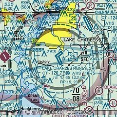
| Sectional chart |
|---|
|
CAUTION: Diagram may not be current
 Download PDF
of official airport diagram from the FAA
| Airport distance calculator |
|---|
|
|
| Sunrise and sunset |
|---|
|
Times for 04-Dec-2025
| | Local
(UTC-6) | | Zulu
(UTC) |
|---|
| Morning civil twilight | | 06:29 | | 12:29 |
| Sunrise | | 06:55 | | 12:55 |
| Sunset | | 17:11 | | 23:11 |
| Evening civil twilight | | 17:38 | | 23:38 |
|
| Current date and time |
|---|
| Zulu (UTC) | 05-Dec-2025 03:07:21 |
|---|
| Local (UTC-6) | 04-Dec-2025 21:07:21 |
|---|
|
| METAR |
|---|
| KLCH | 050253Z 02009KT 10SM OVC022 08/06 A3013 RMK AO2 SLP211 T00780061 53010
|
KCWF
7nm NE | 050245Z 02010KT 10SM OVC015 07/05 A3013
|
KUXL
8nm W | 050255Z AUTO 35009KT 10SM BKN011 OVC023 08/06 A3015 RMK AO2 T00800058
|
|
| TAF |
|---|
| KLCH | 050123Z 0501/0524 01012G22KT 6SM BR OVC005 FM050300 01011KT 5SM BR OVC007 FM051800 02008KT 4SM -RA BR OVC007
|
|
| NOTAMs |
|---|
NOTAMs are issued by the DoD/FAA and will open in a separate window not controlled by AirNav.
|
|


