FAA INFORMATION EFFECTIVE 09 JULY 2026
Location
| FAA Identifier: | LWM |
| Lat/Long: | 42-43-01.3520N 071-07-24.7200W
42-43.022533N 071-07.412000W
42.7170422,-71.1235333
(estimated) |
| Elevation: | 147.6 ft. / 45.0 m (surveyed) |
| Variation: | 15W (1980) |
| From city: | 2 miles E of LAWRENCE, MA |
| Time zone: | UTC -4 (UTC -5 during Standard Time) |
| Zip code: | 01845 |
Airport Operations
| Airport use: | Open to the public |
| Activation date: | 04/1940 |
| Control tower: | yes |
| ARTCC: | BOSTON CENTER |
| FSS: | BRIDGEPORT FLIGHT SERVICE STATION |
| NOTAMs facility: | LWM (NOTAM-D service available) |
| Attendance: | 0700-2200 |
| Wind indicator: | yes |
| Segmented circle: | no |
| Lights: | ACTVT REIL RWY 05, 23, 14 & 32; PAPI RWY 05, 23 & 32; HIRL RWY 05/23; MIRL RWY 14/32 - CTAF. |
| Beacon: | white-green (lighted land airport)
Operates sunset to sunrise. |
| Landing fee: | yes, LNDG FEE FOR ACFT REGISTERED TO CORPORATION ONLY. |
| International operations: | customs landing rights airport |
Airport Communications
| CTAF: | 119.25 |
| UNICOM: | 122.8 |
| ATIS: | 126.75 |
| WX ASOS: | PHONE 978-687-8017 |
| LAWRENCE GROUND: | 124.3 [0700-2200] |
| LAWRENCE TOWER: | 119.25 [0700-2200] |
| BOSTON APPROACH: | 124.4 |
| BOSTON DEPARTURE: | 124.4 |
| CLEARANCE DELIVERY: | 124.3 126.15 ;WHEN LWM TWR CLSD |
| DREEM STAR: | 119.0 124.4 |
| ZELKA STAR: | 124.4 |
| WX ASOS at BVY (12 nm SE): | 119.2 (978-921-5042) |
| WX ASOS at BED (17 nm SW): | 124.6 (781-372-5512) |
| WX AWOS-3PT at ASH (18 nm W): | 125.1 (603-578-0473) |
| WX ASOS at MHT (19 nm NW): | 119.55 (603-626-6902) |
Nearby radio navigation aids
| VOR radial/distance | | VOR name | | Freq | | Var |
|---|
| BOSr001/22.4 | | BOSTON VOR/DME | | 112.70 | | 16W |
| CONr162/36.1 | | CONCORD VOR/DME | | 112.90 | | 15W |
| NDB name | | Hdg/Dist | | Freq | | Var | | ID |
|---|
| ROLLINS | | 219/32.9 | | 260 | | 16W | | ESG | . ... --. |
Airport Services
| Fuel available: | 100LL JET-A JET-A+ |
| Parking: | hangars and tiedowns |
| Airframe service: | MAJOR |
| Powerplant service: | MAJOR |
| Bottled oxygen: | NONE |
| Bulk oxygen: | NONE |
Runway Information
Runway 5/23
| Dimensions: | 5001 x 100 ft. / 1524 x 30 m |
| Surface: | asphalt/grooved, in good condition |
| Weight bearing capacity: | | Single wheel: | 45.0 | | Double wheel: | 62.0 | | Double tandem: | 110.0 |
|
| Runway edge lights: | high intensity |
| RUNWAY 5 | | RUNWAY 23 |
| Latitude: | 42-42.641358N | | 42-43.288565N |
| Longitude: | 071-07.747378W | | 071-07.057322W |
| Elevation: | 134.7 ft. | | 134.1 ft. |
| Traffic pattern: | left | | left |
| Runway heading: | 053 magnetic, 038 true | | 233 magnetic, 218 true |
| Markings: | precision, in good condition | | precision, in good condition |
| Visual slope indicator: | 4-light PAPI on right (3.00 degrees glide path) | | 4-light PAPI on left (3.70 degrees glide path) |
| Runway end identifier lights: | yes | | yes |
| Touchdown point: | yes, no lights | | yes, no lights |
| Instrument approach: | ILS | | |
| Obstructions: | none | | 13 ft. trees, 650 ft. from runway, 34:1 slope to clear |
Runway 14/32
| Dimensions: | 3654 x 100 ft. / 1114 x 30 m |
| Surface: | asphalt, in fair condition |
| Weight bearing capacity: | | Single wheel: | 30.0 | | Double wheel: | 34.0 | | Double tandem: | 53.0 |
|
| Runway edge lights: | medium intensity |
| RUNWAY 14 | | RUNWAY 32 |
| Latitude: | 42-43.259363N | | 42-42.943252N |
| Longitude: | 071-07.772247W | | 071-07.078088W |
| Elevation: | 121.5 ft. | | 147.6 ft. |
| Traffic pattern: | left | | left |
| Runway heading: | 137 magnetic, 122 true | | 317 magnetic, 302 true |
| Displaced threshold: | no | | 80 ft. |
| Markings: | basic, in good condition | | basic, in good condition |
| Visual slope indicator: | | | 4-light PAPI on left (4.00 degrees glide path) |
| Runway end identifier lights: | yes | | yes |
| Touchdown point: | yes, no lights | | yes, no lights |
| Obstructions: | none | | 7 ft. trees, 300 ft. from runway, 125 ft. left of centerline, 14:1 slope to clear
APCH RATIO 50:1 TO DTHR. |
Airport Ownership and Management from official FAA records
| Ownership: | Publicly-owned |
| Owner: | CITY OF LAWRENCE
CITY HALL, 200 COMMON ST
LAWRENCE, MA 08140
Phone 978-620-3014 |
| Manager: | FRANCISCO A. URENA
492 SUTTON ST
NO. ANDOVER, MA 01845
Phone 978-794-5880 |
Additional Remarks
| - | HILL 5400 FT SE & STANDPIPE 7200 FT NE; LGTD. |
| - | WILDLIFE ON & INVOF ARPT. |
| - | LGTD STACK 296 FT MSL 1/2 MI NW AER 23. |
| - | CLSD TFC PAT, INITIATE TURN-OUT AT 700 FT AGL. |
| - | USE RSNBL EFFORTS TO MNTN MANUFACTURER'S RCMDD BEST ROC. |
Instrument Procedures
NOTE: All procedures below are presented as PDF files. If you need a reader for these files, you should download the free Adobe Reader.NOT FOR NAVIGATION. Please procure official charts for flight.
FAA instrument procedures published for use from 09 July 2026 at 0901Z to 06 August 2026 at 0900Z.
STARs - Standard Terminal Arrivals |
|---|
| DREEM THREE (RNAV) **NEW** | |
2 pages:
[1] [2] (348KB) |
| ZELKA TWO (RNAV) **NEW** | |
download (146KB) |
IAPs - Instrument Approach Procedures |
|---|
| ILS OR LOC RWY 05 | |
download (234KB) |
| RNAV (GPS) RWY 05 | |
download (254KB) |
| RNAV (GPS) RWY 14 | |
download (235KB) |
| RNAV (GPS) RWY 23 | |
download (247KB) |
| RNAV (GPS) RWY 32 | |
download (227KB) |
| NOTE: Special Alternate Minimums apply | |
download (150KB) |
Departure Procedures |
|---|
| LAWRENCE TWO | |
2 pages:
[1] [2] (344KB) |
| NOTE: Special Take-Off Minimums/Departure Procedures apply | |
download (178KB) |
Other nearby airports with instrument procedures:
KBVY - Beverly Regional Airport (12 nm SE)
KBED - Laurence G Hanscom Field Airport (17 nm SW)
KASH - Boire Field Airport (18 nm W)
KMHT - Manchester Boston Regional Airport (19 nm NW)
KBOS - General Edward Lawrence Logan International Airport (22 nm S)
|
|

Road maps at:
MapQuest
Bing
Google
| Aerial photo |
|---|
WARNING: Photo may not be current or correct
 Photo by John J. Cronin.
Photo taken 03-Jun-2009
from a Cessna 182.
Photo by John J. Cronin.
Photo taken 03-Jun-2009
from a Cessna 182.
Do you have a better or more recent aerial photo of Lawrence Municipal Airport that you would like to share? If so, please send us your photo.
|
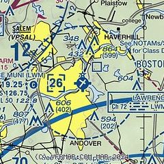
| Sectional chart |
|---|
|
CAUTION: Diagram may not be current
 Download PDF
of official airport diagram from the FAA
| Airport distance calculator |
|---|
|
|
| Sunrise and sunset |
|---|
|
Times for 30-Jul-2026
| | Local
(UTC-4) | | Zulu
(UTC) |
|---|
| Morning civil twilight | | 05:03 | | 09:03 |
| Sunrise | | 05:35 | | 09:35 |
| Sunset | | 20:07 | | 00:07 |
| Evening civil twilight | | 20:39 | | 00:39 |
|
| Current date and time |
|---|
| Zulu (UTC) | 31-Jul-2026 02:10:43 |
|---|
| Local (UTC-4) | 30-Jul-2026 22:10:43 |
|---|
|
| METAR |
|---|
| KLWM | 310154Z 00000KT 10SM SCT006 BKN035 OVC110 18/17 A2989 RMK AO2 SLP122 T01830172
|
KBVY
12nm SE | 310203Z AUTO 32004KT 10SM BKN023 BKN027 OVC035 18/17 A2987 RMK AO2 T01780172
|
KBED
17nm SW | 310203Z 00000KT 10SM SCT028 BKN035 OVC100 18/18 A2986 RMK AO2 T01780178
|
KASH
18nm W | 310156Z AUTO 00000KT 10SM SCT041 BKN070 OVC095 18/18 A2989 RMK AO2 RAB08E41 SLP119 T01830178 PNO $
|
KMHT
19nm NW | 310153Z 26003KT 10SM BKN029 BKN035 OVC070 19/17 A2987 RMK AO2 RAE10 SLP124 P0000 T01940172 $
|
|
| TAF |
|---|
KBED
17nm SW | 302041Z 3021/3118 05006KT P6SM BKN040 FM310000 01004KT P6SM OVC010 TEMPO 3110/3112 5SM BR FM311500 33005KT P6SM SCT050
|
KMHT
19nm NW | 301729Z 3018/3118 02009KT P6SM OVC035 FM302200 02008KT P6SM BKN030 OVC050 FM310600 34005KT P6SM OVC050
|
|
| NOTAMs |
|---|
NOTAMs are issued by the DoD/FAA and will open in a separate window not controlled by AirNav.
|
|


