FAA INFORMATION EFFECTIVE 16 APRIL 2026
Location
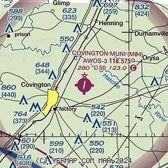
| FAA Identifier: | M04 |
| Lat/Long: | 35-35-00.1100N 089-35-14.0090W
35-35.001833N 089-35.233483W
35.5833639,-89.5872247
(estimated) |
| Elevation: | 280.2 ft. / 85.4 m (surveyed) |
| Variation: | 02W (2025) |
| From city: | 3 miles NE of COVINGTON, TN |
| Time zone: | UTC -5 (UTC -6 during Standard Time) |
| Zip code: | 38019 |
Airport Operations
| Airport use: | Open to the public |
| Activation date: | 12/1958 |
| Control tower: | no |
| ARTCC: | MEMPHIS CENTER |
| FSS: | JACKSON FLIGHT SERVICE STATION |
| NOTAMs facility: | MKL (NOTAM-D service available) |
| Attendance: | 0800-1700
UNATNDD ALL FEDERAL HOLIDAYS. |
| Wind indicator: | lighted |
| Segmented circle: | yes |
| Lights: | ACTVT MIRL RWY 01/19 - CTAF. MIRL RWY 01/19 PRESET LOW INTST; INCR INTST - CTAF. |
| Beacon: | white-green (lighted land airport)
Operates sunset to sunrise. |
Airport Communications
| CTAF/UNICOM: | 123.0 |
| WX AWOS-3: | 118.575 (901-476-1705) |
| MEMPHIS APPROACH: | 125.8 120.075 [0600-2350] |
| MEMPHIS DEPARTURE: | 124.15 [0600-2350] |
| WX AWOS-3 at NQA (19 nm SW): | 118.925 (901-873-3630) |
Nearby radio navigation aids
| VOR radial/distance | | VOR name | | Freq | | Var |
|---|
| MKLr268/33.1 | | MC KELLAR VOR/DME | | 114.85 | | 01W |
| MEMr029/39.2 | | MEMPHIS VORTAC | | 117.50 | | 01E |
Airport Services
| Fuel available: | 100LL JET-A+ |
| Parking: | tiedowns |
| Airframe service: | NONE |
| Powerplant service: | NONE |
| Bottled oxygen: | NONE |
| Bulk oxygen: | NONE |
Runway Information
Runway 1/19
| Dimensions: | 5003 x 100 ft. / 1525 x 30 m |
| Surface: | asphalt, in good condition |
| Weight bearing capacity: | |
| Runway edge lights: | medium intensity |
| Operational restrictions: | CTN: WIP; MOWING & MAINT VEHICLES. |
| RUNWAY 1 | | RUNWAY 19 |
| Latitude: | 35-34.594665N | | 35-35.408995N |
| Longitude: | 089-35.312775W | | 089-35.154177W |
| Elevation: | 280.2 ft. | | 272.2 ft. |
| Traffic pattern: | left | | left |
| Runway heading: | 011 magnetic, 009 true | | 191 magnetic, 189 true |
| Markings: | nonprecision, in good condition | | nonprecision, in good condition |
| Visual slope indicator: | 4-light PAPI on left (3.00 degrees glide path) | | 4-light PAPI on left (3.00 degrees glide path) |
| Runway end identifier lights: | yes | | yes |
| Touchdown point: | yes, no lights | | yes, no lights |
| Obstructions: | 76 ft. tree, 1763 ft. from runway, 247 ft. left of centerline, 20:1 slope to clear | | 42 ft. pole, 1157 ft. from runway, 472 ft. left of centerline, 23:1 slope to clear |
Airport Ownership and Management from official FAA records
| Ownership: | Publicly-owned |
| Owner: | CITY OF COVINGTON
CITY HALL, 200 W. WASHINGTON AVE
COVINGTON, TN 38019
Phone 901-476-9613 |
| Manager: | WILLIAM LABERMEIER
169 AIRPORT PARKWAY DR
COVINGTON, TN 38019
Phone 901-476-1392 |
Additional Remarks
| - | AGRICULTURAL OPS ON & INVOF ARPT MAY 1 - OCT 31. |
| - | FOR CD CTC MEMPHIS APCH AT 901-842-8457. |
| - | FUEL 24 HR SELF SVC WITH CREDIT CARD. |
Instrument Procedures
NOTE: All procedures below are presented as PDF files. If you need a reader for these files, you should download the free Adobe Reader.NOT FOR NAVIGATION. Please procure official charts for flight.
FAA instrument procedures published for use from 16 April 2026 at 0901Z to 14 May 2026 at 0900Z.
IAPs - Instrument Approach Procedures |
|---|
| RNAV (GPS) RWY 01 | |
download (215KB) |
| RNAV (GPS) RWY 19 | |
download (202KB) |
| NOTE: Special Alternate Minimums apply | |
download (162KB) |
| NOTE: Special Take-Off Minimums/Departure Procedures apply | |
download (161KB) |
Other nearby airports with instrument procedures:
KNQA - Millington/Memphis Airport (19 nm SW)
7M4 - Osceola Municipal Airport (22 nm W)
KFYE - Fayette County Airport (24 nm SE)
KHKA - Blytheville Municipal Airport (24 nm NW)
2M8 - Charles W Baker Airport (25 nm SW)
|
|

Road maps at:
MapQuest
Bing
Google
| Aerial photo |
|---|
WARNING: Photo may not be current or correct
 Photo by Tim Henry
Photo taken 27-Nov-2009
Photo by Tim Henry
Photo taken 27-Nov-2009
Do you have a better or more recent aerial photo of Covington Municipal Airport that you would like to share? If so, please send us your photo.
|
| Sectional chart |
|---|
|
CAUTION: Diagram may not be current

| Airport distance calculator |
|---|
|
|
| Sunrise and sunset |
|---|
|
Times for 27-Apr-2026
| | Local
(UTC-5) | | Zulu
(UTC) |
|---|
| Morning civil twilight | | 05:45 | | 10:45 |
| Sunrise | | 06:12 | | 11:12 |
| Sunset | | 19:40 | | 00:40 |
| Evening civil twilight | | 20:07 | | 01:07 |
|
| Current date and time |
|---|
| Zulu (UTC) | 27-Apr-2026 12:18:52 |
|---|
| Local (UTC-5) | 27-Apr-2026 07:18:52 |
|---|
|
| METAR |
|---|
| KM04 | 271150Z AUTO 17007KT 10SM SCT042 BKN075 OVC085 22/18 A2988 RMK A01
|
KNQA
20nm SW | 271155Z AUTO 15006KT 10SM BKN060 OVC080 22/18 A2985 RMK A01
|
|
| TAF |
|---|
KMKL
33nm E | 270520Z 2706/2806 16005KT P6SM FEW050 BKN250 FM271100 16008KT P6SM SCT035 BKN090 FM271500 18014G22KT P6SM BKN030 FM271800 19017G24KT P6SM VCTS BKN035CB PROB30 2718/2723 2SM -TSRA BKN025CB FM280000 19014G22KT P6SM BKN050
|
KMEM
37nm SW | 271120Z 2712/2818 17012KT P6SM SCT035 BKN090 FM271300 18016G26KT P6SM BKN025 OVC040 FM271700 19020G28KT P6SM VCSH BKN040 FM280000 19014G22KT P6SM VCTS SCT040CB PROB30 2802/2808 VRB20G35KT 2SM TSRA BKN015CB FM281000 21009KT P6SM BKN040 FM281200 22007KT P6SM BKN025
|
|
| NOTAMs |
|---|
NOTAMs are issued by the DoD/FAA and will open in a separate window not controlled by AirNav.
|
|


