FAA INFORMATION EFFECTIVE 14 MAY 2026
Location
| FAA Identifier: | MCI |
| Lat/Long: | 39-17-51.4000N 094-42-50.0000W
39-17.856667N 094-42.833333W
39.2976111,-94.7138889
(estimated) |
| Elevation: | 1026.9 ft. / 313.0 m (surveyed) |
| Variation: | 02E (2015) |
| From city: | 15 miles NW of KANSAS CITY, MO |
| Time zone: | UTC -5 (UTC -6 during Standard Time) |
| Zip code: | 64153 |
Airport Operations
| Airport use: | Open to the public |
| Activation date: | 05/1956 |
| Control tower: | yes |
| ARTCC: | KANSAS CITY CENTER |
| FSS: | COLUMBIA FLIGHT SERVICE STATION |
| NOTAMs facility: | MCI (NOTAM-D service available) |
| Attendance: | CONTINUOUS |
| Wind indicator: | lighted |
| Segmented circle: | no |
| Beacon: | white-green (lighted land airport)
Operates sunset to sunrise. |
| Fire and rescue: | ARFF index C |
| International operations: | customs landing rights airport |
Airport Communications
| UNICOM: | 122.95 |
| WX ASOS: | PHONE 816-601-1486 |
| INTERNATIONAL GROUND: | 121.8 121.65 |
| INTERNATIONAL TOWER: | 128.2 254.25 125.75 |
| KANSAS CITY APPROACH: | 120.95 318.1 |
| KANSAS CITY DEPARTURE: | 123.95 ;010-190 124.7 ;191-009 284.7 ;191-009 318.1 ;010-190 |
| CLEARANCE DELIVERY: | 135.7 |
| BRAYMER STAR: | 120.95 318.1 |
| CHIEF DP: | 124.7 284.7 |
| CLASS B: | 118.4 ;EAST OF RWY 01/19 118.9 ;S OF A LINE FROM LWC ARPT TO 124.7 ;WEST OF RWY 01/19 251.075 ;S OF LINE FROM LWC ARPT TO 284.7 ;W OF RWY 19 294.7 ;EAST OF RWY 01-19 294.7 ;S OF A LINE FROM LWC ARPT TO 307.35 ;E OF RWY1/19 318.1 ;WEST OF RWY 01/19 |
| D-ATIS: | 128.375 |
| EMERG: | 121.5 243.0 |
| JHAWK STAR: | 120.95 318.1 |
| LAKES DP: | 123.95 318.1 |
| RACER DP: | 123.95 ;BUTLER/SPRINGFIELD TRANSITIO 124.7 ;DOSOA TRANSITION 284.7 ;DOSOA TRANSITION 318.1 ;BUTLER/SPRINGFIELD TRANSITION |
| ROYAL DP: | 123.95 ;ARENZ/BODYN TRANSITION 124.7 ;TONCE TRANSITION 284.7 ;TONCE TRANSITION 318.1 ;ARENZ/BODYN TRANSITION |
| TIFTO DP: | 124.7 284.7 |
| TYGER STAR: | 120.95 318.1 |
| WILDCAT DP: | 124.7 284.7 |
| WX ASOS at MKC (12 nm SE): | 120.75 (816-329-2843) |
| WX AWOS-3P at GPH (19 nm E): | 120.275 (816-407-3399) |
- ASSC IN USE. OPERATE TRANSPONDERS WITH ALTITUDE REPORTING MODE AND ADS-B (IF EQUIPPED) ENABLED ON ALL AIRPORT SURFACES.
Nearby radio navigation aids
| VOR radial/distance | | VOR name | | Freq | | Var |
|---|
| MCIr050/1.3 | | KANSAS CITY VORTAC | | 113.25 | | 05E |
| ANXr287/29.8 | | NAPOLEON VORTAC | | 115.15 | | 07E |
| NDB name | | Hdg/Dist | | Freq | | Var | | ID |
|---|
| AMAZON | | 162/36.3 | | 233 | | 04E | | AZN | .- --.. -. |
Airport Services
| Fuel available: | 100LL JET-A |
| Parking: | tiedowns |
| Airframe service: | NONE |
| Powerplant service: | NONE |
| Bottled oxygen: | NONE |
| Bulk oxygen: | NONE |
Runway Information
Runway 1L/19R
| Dimensions: | 10801 x 150 ft. / 3292 x 46 m |
| Surface: | concrete/grooved, in excellent condition |
| Weight bearing capacity: | | Single wheel: | 120.0 | | Double wheel: | 250.0 | | Double tandem: | 524.0 | | Dual double tandem: | 450.0 |
|
| Runway edge lights: | high intensity |
| RUNWAY 1L | | RUNWAY 19R |
| Latitude: | 39-17.600048N | | 39-19.333993N |
| Longitude: | 094-43.759055W | | 094-43.246392W |
| Elevation: | 1014.4 ft. | | 979.6 ft. |
| Traffic pattern: | left | | right |
| Runway heading: | 011 magnetic, 013 true | | 191 magnetic, 193 true |
| Declared distances: | TORA:10801 TODA:10801 ASDA:10801 LDA:10801 | | TORA:10801 TODA:10801 ASDA:10801 LDA:10801 |
| Markings: | precision, in good condition | | precision, in good condition |
| Visual slope indicator: | 4-light PAPI on left (3.00 degrees glide path) | | 4-light PAPI on right (3.00 degrees glide path) |
| RVR equipment: | touchdown, midfield, rollout | | touchdown, midfield, rollout |
| Approach lights: | MALSR: 1,400 foot medium intensity approach lighting system with runway alignment indicator lights | | ALSF2: standard 2,400 foot high intensity approach lighting system with centerline sequenced flashers (category II or III) |
| Centerline lights: | yes | | yes |
| Touchdown point: | yes, lighted | | yes, lighted |
| Instrument approach: | ILS/DME | | ILS/DME |
Runway 9/27
| Dimensions: | 9501 x 150 ft. / 2896 x 46 m |
| Surface: | asphalt/grooved, in good condition |
| Weight bearing capacity: | | Single wheel: | 120.0 | | Double wheel: | 250.0 | | Double tandem: | 465.0 | | Dual double tandem: | 260.0 |
|
| Runway edge lights: | high intensity |
| RUNWAY 9 | | RUNWAY 27 |
| Latitude: | 39-17.451650N | | 39-17.284527N |
| Longitude: | 094-43.595618W | | 094-41.593297W |
| Elevation: | 1015.3 ft. | | 1026.9 ft. |
| Traffic pattern: | left | | right |
| Runway heading: | 094 magnetic, 096 true | | 274 magnetic, 276 true |
| Declared distances: | TORA:9501 TODA:9501 ASDA:9501 LDA:9501 | | TORA:9501 TODA:9501 ASDA:9501 LDA:9501 |
| Markings: | precision, in good condition | | precision, in good condition |
| Visual slope indicator: | | | 4-light PAPI on left (3.00 degrees glide path) |
| RVR equipment: | touchdown, rollout | | touchdown, rollout |
| Approach lights: | MALSR: 1,400 foot medium intensity approach lighting system with runway alignment indicator lights | | MALSR: 1,400 foot medium intensity approach lighting system with runway alignment indicator lights |
| Runway end identifier lights: | no | | |
| Touchdown point: | yes, no lights | | yes, no lights |
| Instrument approach: | ILS/DME | | ILS/DME |
Runway 1R/19L
| Dimensions: | 9500 x 150 ft. / 2896 x 46 m |
| Surface: | concrete/grooved, in excellent condition |
| Weight bearing capacity: | | Single wheel: | 120.0 | | Double wheel: | 250.0 | | Double tandem: | 550.0 | | Dual double tandem: | 450.0 |
|
| Runway edge lights: | high intensity |
| RUNWAY 1R | | RUNWAY 19L |
| Latitude: | 39-16.887235N | | 39-18.412282N |
| Longitude: | 094-42.539892W | | 094-42.088710W |
| Elevation: | 1017.2 ft. | | 978.5 ft. |
| Traffic pattern: | left | | left |
| Runway heading: | 011 magnetic, 013 true | | 191 magnetic, 193 true |
| Declared distances: | TORA:9500 TODA:9500 ASDA:9500 LDA:9500 | | TORA:9500 TODA:9500 ASDA:9500 LDA:9500 |
| Markings: | precision, in good condition | | precision, in good condition |
| Visual slope indicator: | 4-light PAPI on right (3.00 degrees glide path) | | |
| RVR equipment: | touchdown, midfield, rollout | | touchdown, midfield, rollout |
| Approach lights: | ALSF2: standard 2,400 foot high intensity approach lighting system with centerline sequenced flashers (category II or III) | | MALSR: 1,400 foot medium intensity approach lighting system with runway alignment indicator lights |
| Centerline lights: | yes | | yes |
| Touchdown point: | yes, lighted | | yes, lighted |
| Instrument approach: | ILS/DME | | ILS/DME |
Airport Ownership and Management from official FAA records
| Ownership: | Publicly-owned |
| Owner: | CITY OF KANSAS CITY
601 BRASILIA; PO BOX 20047
KANSAS CITY, MO 64141
Phone 816-243-3100 |
| Manager: | MR. LUKE MAWHIRTER
P.O. BOX 20047
KANSAS CITY, MO 64195
Phone 816-243-5248 |
Additional Remarks
| A39-01L/19R | PCR VALUE: 1106/R/D/W/T |
| A39-09/27 | PCR VALUE: 646/F/B/X/T |
| A39-01R/19L | PCR VALUE: 1107/R/B/W/T |
| - | WATERFOWL ON AND INVOF ARPT. |
| - | PPR TO PARK AT TRML GATES CTC ARPT OPN 816-835-4315 |
| - | WHEN USING HIGH-SPEED EXITS C4 & C6 CONT TIL FIRST PARL TWY, THEN USE EXTREME CARE WHEN TURNING IN EXCESS OF 90 DEGREES. |
| - | NO ACFT PARKING ON POSTAL APRON. |
| - | DESIGN GROUP V AND VI ACFT RQR AN ARPT ESCORT ON TWY DELTA BTWN TWYS JULIET & C9. |
| - | TWY B1 BTN TWY B AND FEDEX APN COCKPIT OVER CNTRLN STEERING RQRD |
| - | TWY C2 BTN TWY C3 AND TWY C1 WINGSPAN RESTRICTION OF 118 FT. |
| - | TXL W, N1, N3, M1, M3, S1, S3, D1, & D3 WINGSPAN RESTRICTION OF 118 FT. |
| - | N RAMP CTL FREQ: 128.975 |
| - | S RAMP CTL FREQ: 130.825 |
| - | TWY B2 CLSD TO ACFT WINGSPAN MORE THAN 135FT. |
| - | WINDSHEAR ALERT SYSTEM ON ARPT. |
| - | NOISE ABATEMENT PROCEDURES IN EFFECT 2200-0600 WITH LANDING ON RYS 01L & 19L; TAKEOFFS ON RYS 01R & 19R. |
| - | MIL ACFT MAY BE CHARGED RAMP/PARKING FEES. |
Instrument Procedures
NOTE: All procedures below are presented as PDF files. If you need a reader for these files, you should download the free Adobe Reader.NOT FOR NAVIGATION. Please procure official charts for flight.
FAA instrument procedures published for use from 14 May 2026 at 0901Z to 11 June 2026 at 0900Z.
STARs - Standard Terminal Arrivals |
|---|
| BRAYMER EIGHT | |
2 pages:
[1] [2] (345KB) |
| JHAWK EIGHT | |
download (221KB) |
| JSONN FOUR (RNAV) | |
2 pages:
[1] [2] (309KB) |
| JSONN FOUR (RNAV), CONT.2 | |
download (308KB) |
| MHOMS THREE (RNAV) | |
2 pages:
[1] [2] (298KB) |
| MHOMS THREE (RNAV), CONT.2 | |
download (304KB) |
| RUDDH THREE (RNAV) | |
2 pages:
[1] [2] (326KB) |
| RUDDH THREE (RNAV), CONT.2 | |
download (298KB) |
| TYGER SEVEN | |
2 pages:
[1] [2] (291KB) |
| WUTNG THREE (RNAV) | |
2 pages:
[1] [2] (302KB) |
| WUTNG THREE (RNAV), CONT.2 | |
download (312KB) |
IAPs - Instrument Approach Procedures |
|---|
| ILS OR LOC RWY 01L | |
download (374KB) |
| ILS OR LOC RWY 01R | |
download (398KB) |
| ILS OR LOC RWY 09 | |
download (331KB) |
| ILS OR LOC RWY 19L | |
download (370KB) |
| ILS OR LOC RWY 19R | |
download (380KB) |
| ILS OR LOC RWY 27 | |
download (372KB) |
| ILS RWY 01R (SA CAT I) | |
download (369KB) |
| ILS RWY 19R (SA CAT I) | |
download (352KB) |
| ILS RWY 01R (CAT II - III) | |
download (378KB) |
| ILS RWY 19R (CAT II - III) | |
download (366KB) |
| RNAV (RNP) Z RWY 01L | |
download (247KB) |
| RNAV (RNP) Z RWY 01R | |
download (249KB) |
| RNAV (RNP) Z RWY 09 | |
download (230KB) |
| RNAV (RNP) Z RWY 19L | |
download (245KB) |
| RNAV (RNP) Z RWY 19R | |
download (246KB) |
| RNAV (RNP) Z RWY 27 | |
download (244KB) |
| RNAV (GPS) Y RWY 01L | |
download (257KB) |
| RNAV (GPS) Y RWY 01R | |
download (263KB) |
| RNAV (GPS) Y RWY 09 | |
download (223KB) |
| RNAV (GPS) Y RWY 19L | |
download (248KB) |
| RNAV (GPS) Y RWY 19R | |
download (258KB) |
| RNAV (GPS) Y RWY 27 | |
download (234KB) |
Departure Procedures |
|---|
| CHIEF NINE | |
download (156KB) |
| LAKES FIVE | |
download (211KB) |
| RACER EIGHT | |
download (208KB) |
| ROYAL TWO | |
download (189KB) |
| TIFTO EIGHT | |
download (136KB) |
| WILDCAT SIX | |
download (180KB) |
| NOTE: Special Take-Off Minimums/Departure Procedures apply | |
download (158KB) |
Other nearby airports with instrument procedures:
KFLV - Sherman Army Airfield (10 nm NW)
KMKC - Kansas City Downtown Airport-Wheeler Field (12 nm SE)
KGPH - Midwest National Air Center Airport (19 nm E)
3EX - Excelsior Springs Memorial Airport (24 nm E)
KLXT - Kansas City/Lee's Summit Regional Airport (26 nm SE)
|
|

Road maps at:
MapQuest
Bing
Google
| Aerial photo |
|---|
WARNING: Photo may not be current or correct
 Photo by Gregory White
Photo taken 30-Apr-2008
Photo by Gregory White
Photo taken 30-Apr-2008
Do you have a better or more recent aerial photo of Kansas City International Airport that you would like to share? If so, please send us your photo.
|
| Sectional chart |
|---|
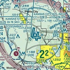
|
| Airport distance calculator |
|---|
|
|
| Sunrise and sunset |
|---|
|
Times for 10-Jun-2026
| | Local
(UTC-5) | | Zulu
(UTC) |
|---|
| Morning civil twilight | | 05:21 | | 10:21 |
| Sunrise | | 05:53 | | 10:53 |
| Sunset | | 20:44 | | 01:44 |
| Evening civil twilight | | 21:16 | | 02:16 |
|
| Current date and time |
|---|
| Zulu (UTC) | 10-Jun-2026 06:55:53 |
|---|
| Local (UTC-5) | 10-Jun-2026 01:55:53 |
|---|
|
| METAR |
|---|
| KMCI | 100553Z 20016G29KT 10SM CLR 27/21 A2982 RMK AO2 PK WND 21032/0538 SLP082 T02670211 10300 20267 403170194 58009
|
KMKC
12nm SE | 100554Z 20015G26KT 10SM CLR 27/21 A2983 RMK AO2 PK WND 19026/0546 SLP090 T02720211 10317 20272 403280206 57006
|
KGPH
19nm E | 100635Z AUTO 21009G14KT 10SM CLR 27/21 A2982 RMK AO2
|
|
| TAF |
|---|
| KMCI | 100535Z 1006/1106 20015G25KT P6SM SCT250 FM101300 21015G25KT P6SM BKN150 PROB30 1013/1016 -SHRA FM101600 21020G33KT P6SM SCT050 PROB30 1021/1024 3SM TSRA BR BKN040CB FM110000 18008KT P6SM SCT060
|
KMKC
12nm SE | 100535Z 1006/1106 20013G20KT P6SM SCT250 FM101300 21015G25KT P6SM BKN150 PROB30 1013/1016 -SHRA FM101600 21020G33KT P6SM SCT050 PROB30 1021/1024 3SM TSRA BR BKN040CB FM110000 18008KT P6SM SCT060
|
|
| NOTAMs |
|---|
NOTAMs are issued by the DoD/FAA and will open in a separate window not controlled by AirNav.
|
|


