FAA INFORMATION EFFECTIVE 27 NOVEMBER 2025
Location
| FAA Identifier: | MWL |
| Lat/Long: | 32-46-53.7800N 098-03-36.6300W
32-46.896333N 098-03.610500W
32.7816056,-98.0601750
(estimated) |
| Elevation: | 973.6 ft. / 297 m (estimated) |
| Variation: | 06E (2000) |
| From city: | 3 miles SE of MINERAL WELLS, TX |
| Time zone: | UTC -6 (UTC -5 during Daylight Saving Time) |
| Zip code: | 76067 |
Airport Operations
| Airport use: | Open to the public |
| Activation date: | 05/1943 |
| Control tower: | no |
| ARTCC: | FORT WORTH CENTER |
| FSS: | FORT WORTH FLIGHT SERVICE STATION |
| NOTAMs facility: | MWL (NOTAM-D service available) |
| Attendance: | 0600-2000 |
| Wind indicator: | lighted |
| Segmented circle: | yes |
| Lights: | DUSK-DAWN. MIRL RWYS 13/31 & 17/35 PRESET LOW INTST; TO INCR INTST ACTVT - CTAF. |
| Beacon: | white-green (lighted land airport)
Operates sunset to sunrise. |
Airport Communications
| CTAF/UNICOM: | 122.725 |
| WX ASOS: | 135.075 (940-325-2457) |
- APCH/DEP CTL SVC PRVDD BY FORT WORTH ARTCC (ZFW) ON FREQS 127.0/360.6 (MINERAL WELLS RCAG).
Nearby radio navigation aids
| VOR radial/distance | | VOR name | | Freq | | Var |
|---|
| MQPr307/4.6 | | MILLSAP VORTAC | | 117.70 | | 09E |
Airport Services
| Fuel available: | 100LL JET-A
100LL:FOR FUEL AFT HRS CALL 940-328-7770. |
| Parking: | tiedowns |
| Bulk oxygen: | NONE |
Runway Information
Runway 13/31
| Dimensions: | 5996 x 100 ft. / 1828 x 30 m |
| Surface: | asphalt, in good condition |
| Weight bearing capacity: | | Single wheel: | 50.0 | | Double wheel: | 145.0 |
|
| Runway edge lights: | medium intensity |
| RUNWAY 13 | | RUNWAY 31 |
| Latitude: | 32-47.245533N | | 32-46.539000N |
| Longitude: | 098-03.856867W | | 098-03.037833W |
| Elevation: | 913.0 ft. | | 969.3 ft. |
| Traffic pattern: | left | | left |
| Runway heading: | 130 magnetic, 136 true | | 310 magnetic, 316 true |
| Displaced threshold: | 300 ft. | | 400 ft. |
| Markings: | nonprecision, in fair condition | | precision, in fair condition |
| Visual slope indicator: | 4-light PAPI on left (3.00 degrees glide path) | | 4-light PAPI on left (3.00 degrees glide path) |
| Touchdown point: | yes, no lights | | yes, no lights |
| Instrument approach: | | | ILS/DME |
| Obstructions: | 9 ft. fence, 201 ft. from runway, 345 ft. right of centerline
8 FT FENCE, 199 FT DSTC, 347 FT R, 15 FT RD, 199 FT DSTC, 390 FT R. | | 15 ft. trees, 201 ft. from runway, 130 ft. left and right of centerline
10 FT GND 0-199 DSTC, 15 FT TREES, 175 FT DSTC, 150 FT R. |
Runway 17/35
| Dimensions: | 4188 x 100 ft. / 1277 x 30 m |
| Surface: | asphalt, in good condition |
| Weight bearing capacity: | | Single wheel: | 50.0 | | Double wheel: | 145.0 |
|
| Runway edge lights: | medium intensity |
| RUNWAY 17 | | RUNWAY 35 |
| Latitude: | 32-47.247200N | | 32-46.556600N |
| Longitude: | 098-03.839883W | | 098-03.848617W |
| Elevation: | 913.9 ft. | | 955.7 ft. |
| Traffic pattern: | left | | left |
| Runway heading: | 175 magnetic, 181 true | | 355 magnetic, 001 true |
| Displaced threshold: | no | | 286 ft. |
| Markings: | basic, in fair condition | | basic, in fair condition |
| Visual slope indicator: | 2-light PAPI on right (3.00 degrees glide path) | | 2-light PAPI on left (4.00 degrees glide path)
PAPI UNUSBL BYD 3 DEG L OF CNTRLN. |
| Touchdown point: | yes, no lights | | yes, no lights |
| Obstructions: | 35 ft. trees, 556 ft. from runway, 20 ft. left of centerline, 10:1 slope to clear | | 55 ft. trees, 486 ft. from runway, 185 ft. left of centerline, 5:1 slope to clear
APCH SLOPE 14:1 TO DSPLCD THR. |
Airport Ownership and Management from official FAA records
| Ownership: | Publicly-owned |
| Owner: | CITY OF MINERAL WELLS
PO BOX 460
MINERAL WELLS, TX 76068
Phone 940-328-7700 |
| Manager: | HALEY CUEVAS
5300 AIRPORT RD.
MINERAL WELLS, TX 76067
Phone 940-328-7809 |
Additional Remarks
| - | RWY 13/31 RWY ENDS NOT VSB FM OPPOSITE END. |
| - | FOR CD IF UNA TO CTC ON FSS FREQ, CTC FORT WORTH ARTCC AT 817-858-7584. |
| - | RWY 13, DITCH 6 FT DEEP, 8 FT WIDE, 50 FT LONG, BTWN RWY THR & TWY A. |
Instrument Procedures
NOTE: All procedures below are presented as PDF files. If you need a reader for these files, you should download the free Adobe Reader.NOT FOR NAVIGATION. Please procure official charts for flight.
FAA instrument procedures published for use from 27 November 2025 at 0901Z to 25 December 2025 at 0900Z.
IAPs - Instrument Approach Procedures |
|---|
| ILS OR LOC RWY 31 **CHANGED** | |
download (186KB) |
| RNAV (GPS) RWY 13 **CHANGED** | |
download (191KB) |
| RNAV (GPS) RWY 31 **CHANGED** | |
download (193KB) |
| VOR RWY 31 **CHANGED** | |
download (205KB) |
| NOTE: Special Alternate Minimums apply | |
download (137KB) |
| NOTE: Special Take-Off Minimums/Departure Procedures apply | |
download (340KB) |
Other nearby airports with instrument procedures:
KWEA - Parker County Airport (19 nm E)
F35 - Possum Kingdom Airport (21 nm NW)
KGDJ - Granbury Regional Airport (24 nm SE)
KXBP - Bridgeport Municipal Airport (26 nm NE)
50F - Bourland Field Airport (27 nm SE)
|
|

Road maps at:
MapQuest
Bing
Google
| Aerial photo |
|---|
WARNING: Photo may not be current or correct
 Photo by Kurtis K. Samples, AMS
Photo taken 25-May-2012
rom 5500' looking northwest.
Photo by Kurtis K. Samples, AMS
Photo taken 25-May-2012
rom 5500' looking northwest.
Do you have a better or more recent aerial photo of Mineral Wells Regional Airport that you would like to share? If so, please send us your photo.
|
| Sectional chart |
|---|
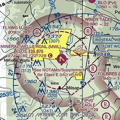
|
CAUTION: Diagram may not be current

| Airport distance calculator |
|---|
|
|
| Sunrise and sunset |
|---|
|
Times for 30-Nov-2025
| | Local
(UTC-6) | | Zulu
(UTC) |
|---|
| Morning civil twilight | | 06:50 | | 12:50 |
| Sunrise | | 07:17 | | 13:17 |
| Sunset | | 17:25 | | 23:25 |
| Evening civil twilight | | 17:52 | | 23:52 |
|
| Current date and time |
|---|
| Zulu (UTC) | 30-Nov-2025 14:41:14 |
|---|
| Local (UTC-6) | 30-Nov-2025 08:41:14 |
|---|
|
| METAR |
|---|
| KMWL | 301353Z AUTO 36010KT 10SM OVC065 00/M07 A3043 RMK AO2 SLP305 T00001072
|
|
| TAF |
|---|
KFTW
35nm E | 301135Z 3012/0112 36016KT P6SM BKN070 FM301700 01012KT P6SM BKN250 FM010100 06008KT P6SM BKN035 FM011100 08006KT P6SM VCSH BKN025
|
|
| NOTAMs |
|---|
NOTAMs are issued by the DoD/FAA and will open in a separate window not controlled by AirNav.
|
|


