FAA INFORMATION EFFECTIVE 14 MAY 2026
Location
| FAA Identifier: | MZZ |
| Lat/Long: | 40-29-23.7000N 085-40-47.2000W
40-29.395000N 085-40.786667W
40.4899167,-85.6797778
(estimated) |
| Elevation: | 858.7 ft. / 261.7 m (surveyed) |
| Variation: | 03W (1985) |
| From city: | 3 miles SW of MARION, IN |
| Time zone: | UTC -4 (UTC -5 during Standard Time) |
| Zip code: | 46953 |
Airport Operations
| Airport use: | Open to the public |
| Activation date: | 02/1938 |
| Control tower: | no |
| ARTCC: | CHICAGO CENTER |
| FSS: | TERRE HAUTE FLIGHT SERVICE STATION |
| NOTAMs facility: | HUF (NOTAM-D service available) |
| Attendance: | MON-FRI 0700-1800, ALL SAT 0800-1700, ALL SUN 0800-1700
UNATNDD CHRISTMAS DAY. |
| Wind indicator: | lighted |
| Segmented circle: | yes |
| Lights: | ACTVT MALSR RWY 04; REIL RWY 15, 22 & 33; PAPI RWY 22- CTAF. PAPI RWY 15 & 33 ON DURG DAY; ACTVT AT NIGHT- CTAF. HIRL RWY 04/22; MIRL RWY 15/33 PRESET LOW INTST; INCR INTST - CTAF. |
| Beacon: | white-green (lighted land airport)
Operates sunset to sunrise. |
Airport Communications
| CTAF/UNICOM: | 122.7 |
| WX AWOS-3: | 108.6 (765-674-1317) |
| GRISSOM APPROACH: | 121.05 |
| GRISSOM DEPARTURE: | 121.05 |
| CLEARANCE DELIVERY: | 120.0 |
| WX AWOS-3PT at OKK (17 nm W): | 128.675 (765-452-3014) |
| WX ASOS at MIE (20 nm SE): | 132.675 (765-288-9617) |
- APCH/DEP SVC PRVDD BY CHICAGO ARTCC ON FREQS 121.05 (REMOTED FROM GRISSOM) WHEN GRISSOM APCH CTL CLSD.
Nearby radio navigation aids
| VOR radial/distance | | VOR name | | Freq | | Var |
|---|
| MZZ at field | | MARION VOR/DME | | 108.60 | | 03W |
| FWAr223/36.9 | | FORT WAYNE VORTAC | | 117.80 | | 06W |
Airport Services
| Fuel available: | 100LL JET-A
100LL:SELF SVC AVBL. |
| Parking: | hangars and tiedowns |
| Airframe service: | MAJOR |
| Powerplant service: | MAJOR |
| Bottled oxygen: | LOW |
| Bulk oxygen: | LOW |
Runway Information
Runway 4/22
| Dimensions: | 6011 x 100 ft. / 1832 x 30 m |
| Surface: | asphalt/grooved, in good condition |
| Weight bearing capacity: | | PCN 28 /F/C/Y/T | | Single wheel: | 60.0 | | Double wheel: | 90.0 | | Double tandem: | 70.0 |
|
| Runway edge lights: | high intensity |
| RUNWAY 4 | | RUNWAY 22 |
| Latitude: | 40-29.007787N | | 40-29.792217N |
| Longitude: | 085-41.215872W | | 085-40.425062W |
| Elevation: | 858.1 ft. | | 850.0 ft. |
| Traffic pattern: | left | | left |
| Runway heading: | 040 magnetic, 037 true | | 220 magnetic, 217 true |
| Markings: | precision, in good condition | | nonprecision, in good condition |
| Visual slope indicator: | | | 4-light PAPI on left (3.00 degrees glide path) |
| Approach lights: | MALSR: 1,400 foot medium intensity approach lighting system with runway alignment indicator lights | | |
| Runway end identifier lights: | | | yes |
| Touchdown point: | yes, no lights | | yes, no lights |
| Instrument approach: | ILS | | |
Runway 15/33
| Dimensions: | 3456 x 100 ft. / 1053 x 30 m |
| Surface: | asphalt/grooved, in good condition |
| Weight bearing capacity: | | Single wheel: | 22.0 | | Double wheel: | 32.0 |
|
| Runway edge lights: | medium intensity |
| RUNWAY 15 | | RUNWAY 33 |
| Latitude: | 40-29.635795N | | 40-29.141080N |
| Longitude: | 085-40.913225W | | 085-40.544510W |
| Elevation: | 857.5 ft. | | 849.5 ft. |
| Traffic pattern: | left | | left |
| Runway heading: | 153 magnetic, 150 true | | 333 magnetic, 330 true |
| Markings: | basic, in good condition | | basic, in good condition |
| Visual slope indicator: | 2-light PAPI on left (3.25 degrees glide path) | | 2-light PAPI on left (4.00 degrees glide path)
PAPI UNUSBL BYD 9 DEGS LEFT OF CNTRLN. |
| Runway end identifier lights: | yes | | yes |
| Touchdown point: | yes, no lights | | yes, no lights |
| Obstructions: | 15 ft. tree, 400 ft. from runway, 120 ft. left of centerline, 13:1 slope to clear | | 10 ft. trees, 300 ft. from runway, 190 ft. left of centerline, 10:1 slope to clear |
Airport Ownership and Management from official FAA records
| Ownership: | Publicly-owned |
| Owner: | CITY OF MARION BOAC
5904 S WESTERN AVE
MARION, IN 46953
Phone 765-674-7777 |
| Manager: | ANDY DARLINGTON
5904 S WESTERN AVE
MARION, IN 46953
Phone 765-674-7777 |
Additional Remarks
| A58-22 | CROPS 285 R & 315 L OF CNTRLN. |
| A30A-33 | -12 FT DITCH 200 FT L OF CNTRLN; 8 - 10 FT GND 230 FT L OF CNTRLN PARL S HALF OF RWY. |
| - | FOR CD CTC CHICAGO ARTCC AT 630-906-8921. |
Instrument Procedures
NOTE: All procedures below are presented as PDF files. If you need a reader for these files, you should download the free Adobe Reader.NOT FOR NAVIGATION. Please procure official charts for flight.
FAA instrument procedures published for use from 14 May 2026 at 0901Z to 11 June 2026 at 0900Z.
IAPs - Instrument Approach Procedures |
|---|
| ILS OR LOC RWY 04 **CHANGED** | |
download (239KB) |
| RNAV (GPS) RWY 04 **CHANGED** | |
download (221KB) |
| RNAV (GPS) RWY 15 **CHANGED** | |
download (187KB) |
| RNAV (GPS) RWY 22 **CHANGED** | |
download (193KB) |
| RNAV (GPS) RWY 33 **CHANGED** | |
download (212KB) |
| NOTE: Special Alternate Minimums apply | |
download (168KB) |
| NOTE: Special Take-Off Minimums/Departure Procedures apply | |
download (499KB) |
Other nearby airports with instrument procedures:
KIWH - Wabash Municipal Airport (17 nm N)
KOKK - Kokomo Municipal Airport (17 nm W)
KMIE - Delaware County Regional Airport (20 nm SE)
KAID - Anderson Regional Airport (23 nm S)
KGUS - Grissom Air Reserve Base (24 nm NW)
|
|

Road maps at:
MapQuest
Bing
Google
| Aerial photo |
|---|
WARNING: Photo may not be current or correct

Do you have a better or more recent aerial photo of Marion Municipal Airport - McKinney Field that you would like to share? If so, please send us your photo.
|
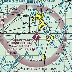
| Sectional chart |
|---|
|
| Airport distance calculator |
|---|
|
|
| Sunrise and sunset |
|---|
|
Times for 20-May-2026
| | Local
(UTC-4) | | Zulu
(UTC) |
|---|
| Morning civil twilight | | 05:51 | | 09:51 |
| Sunrise | | 06:23 | | 10:23 |
| Sunset | | 20:56 | | 00:56 |
| Evening civil twilight | | 21:27 | | 01:27 |
|
| Current date and time |
|---|
| Zulu (UTC) | 21-May-2026 00:35:19 |
|---|
| Local (UTC-4) | 20-May-2026 20:35:19 |
|---|
|
| METAR |
|---|
| KMZZ | 210015Z AUTO 08007KT 10SM SCT090 14/11 A3018 RMK AO2 T01420106
|
KOKK
17nm W | 202356Z AUTO 09011KT 10SM CLR 17/13 A3017 RMK AO2 SLP216 T01670133 10189 20161 56004 $
|
|
| TAF |
|---|
KGUS
23nm W | 202100Z 2021/2203 02009KT 9999 BKN030 BKN200 QNH3015INS BECMG 2112/2113 07012G20KT 9999 FEW025 SCT090 QNH3023INS BECMG 2121/2122 07010KT 9999 FEW250 QNH3013INS TX20/2121Z TN08/2111Z LAST NO AMDS AFT 2103 NEXT 2113
|
|
| NOTAMs |
|---|
NOTAMs are issued by the DoD/FAA and will open in a separate window not controlled by AirNav.
|
|


