FAA INFORMATION EFFECTIVE 27 NOVEMBER 2025
Location
| FAA Identifier: | NEL |
| Lat/Long: | 40-02-08.8358N 074-21-04.9174W
40-02.147263N 074-21.081957W
40.0357877,-74.3513659
(estimated) |
| Elevation: | 100.6 ft. / 31 m (estimated) |
| Variation: | 11W (1980) |
| From city: | 3 miles W of LAKEHURST, NJ |
| Time zone: | UTC -5 (UTC -4 during Daylight Saving Time) |
| Zip code: | 08733 |
Airport Operations
| Airport use: | Private use. Permission required prior to landing |
| Activation date: | 02/1938 |
| Control tower: | yes |
| ARTCC: | NEW YORK CENTER |
| FSS: | MILLVILLE FLIGHT SERVICE STATION |
| NOTAMs facility: | MIV (NOTAM-D service available) |
| Attendance: |
OPR 1300-0100Z++ MON-FRI. EXT HR 0100-0500Z++ MON-THU FOR SKED ACFT ASSAULT LANDING ZONE (ALZ) NIGHT VISION DEVICE (NVD) AND LCL NJ ANG/USMC OPS ONLY. OT BY NOTAM. ALZ EXTENDED HRS FOR SCHEDULED ACFT ONLY. ALZ MUST BE SCHEDULED BY THE FLT CREW AT LEAST 1 DUTY DAY PRIOR TO MSN EXECUTION. CLSD SAT, SUN AND FEDERAL HOLS, EXCEPT FOR SCHEDULED UTA TRNG. NO ACFT OPR WILL BE APV OUTSIDE THESE HRS WO 48 HR PPR. |
| Segmented circle: | no |
| Lights: | PCL-127.775, KEY 3 TIMES FOR LIRL, 5 TIMES FOR MIRL, 7 TIMES FOR HIRL. MALSR ARE ON SAME KEY CODE. |
| Beacon: | white-white-green (lighted military airport)
Operates sunset to sunrise. |
| International operations: | customs landing rights airport |
Airport Communications
| ATIS: | 276.525 |
| LAKEHURST GROUND: | 118.375 307.375 [MON-WED 1300-1700Z++ THU-FRI 1300-0100Z++.] |
| LAKEHURST TOWER: | 127.775 360.2 340.2 [MON-WED 1300-1700Z++ THU-FRI 1300-0100Z++.] |
| MC GUIRE APPROACH: | 126.475 |
| MC GUIRE DEPARTURE: | 126.475 |
| AR OPS: | 41.25FM |
| ARMY OPS: | 255.7 |
| EMERG: | 121.5 243.0 |
| WX AWOS-3PT at MJX (7 nm S): | 119.875 (732-797-2542) |
| WX AWOS-AV at N12 (8 nm E): | 122.8 (732-363-6471) |
| WX AWOS-3PT at BLM (14 nm NE): | 121.625 (732-938-3330) |
- ARMY OPERATIONS HRS 0700-1800
Nearby radio navigation aids
| VOR radial/distance | | VOR name | | Freq | | Var |
|---|
| GXUr094/11.4 | | MC GUIRE VORTAC | | 110.60 | | 12W |
| RBVr157/12.0 | | ROBBINSVILLE VORTAC | | 113.80 | | 10W |
| CYNr026/13.6 | | COYLE VORTAC | | 113.40 | | 10W |
| COLr219/18.7 | | COLTS NECK VOR/DME | | 115.40 | | 11W |
| ARDr127/28.7 | | YARDLEY VOR/DME | | 108.20 | | 10W |
| ACYr027/36.3 | | ATLANTIC CITY VORTAC | | 117.15 | | 10W |
| SBJr161/37.4 | | SOLBERG VOR/DME | | 112.90 | | 10W |
| NDB name | | Hdg/Dist | | Freq | | Var | | ID |
|---|
| LAKEHURST | | at field | | 396 | | 11W | | NEL | -. . .-.. |
Airport Services
| Bottled oxygen: | NONE |
| Bulk oxygen: | NONE |
Runway Information
Runway 6/24
| Dimensions: | 5002 x 150 ft. / 1525 x 46 m |
| Surface: | asphalt |
| Weight bearing capacity: | |
| Runway edge lights: | high intensity |
| RUNWAY 6 | | RUNWAY 24 |
| Latitude: | 40-01.890922N | | 40-02.414872N |
| Longitude: | 074-21.394607W | | 074-20.567332W |
| Elevation: | 88.0 ft. | | 100.6 ft. |
| Traffic pattern: | left | | right |
| Runway heading: | 062 magnetic, 051 true | | 242 magnetic, 231 true |
| Visual slope indicator: | | | 4-light PAPI on left (3.00 degrees glide path) |
| Approach lights: | | | MALS: 1,400 foot medium intensity approach lighting system |
| Touchdown point: | yes, no lights | | yes, no lights |
Runway 15/33
| Dimensions: | 5001 x 150 ft. / 1524 x 46 m |
| Surface: | asphalt |
| Weight bearing capacity: | |
| RUNWAY 15 | | RUNWAY 33 |
| Latitude: | 40-02.377560N | | 40-01.741650N |
| Longitude: | 074-21.617385W | | 074-20.935952W |
| Elevation: | 97.1 ft. | | 87.9 ft. |
| Traffic pattern: | right | | left |
| Runway heading: | 152 magnetic, 141 true | | 332 magnetic, 321 true |
| Touchdown point: | yes, no lights | | yes, no lights |
Runway 63/243
| Dimensions: | 3500 x 90 ft. / 1067 x 27 m |
| Surface: | concrete |
| Weight bearing capacity: | |
| RUNWAY 63 | | RUNWAY 243 |
| Latitude: | 40-02.081200N | | 40-02.447767N |
| Longitude: | 074-21.237412W | | 074-20.658622W |
| Elevation: | 85.9 ft. | | 99.6 ft. |
| Traffic pattern: | left | | left |
| Runway heading: | 061 magnetic, 050 true | | 242 magnetic, 231 true |
| Touchdown point: | yes, no lights | | yes, no lights |
Airport Ownership and Management from official FAA records
| Ownership: | U.S. Navy |
| Owner: | USAF JB MCGUIRE DIX LAKEHURST
2901 FALCON LANE
MCGUIRE, NJ 08641
Phone 609-754-2714 |
| Manager: | AIRFIELD MANAGEMENT
31 ROUNDS RD, BLDG 307, STE 201
LAKEHURST, NJ 08733
Phone 732-323-4995 |
Additional Remarks
| - | SERVICE-LGT-ROTG BCN 110 DEG 2 NM FM ARPT. |
| - | CAUTION: BIRD AND WILDLIFE HAZ. ANCPT CONCENTRATION OF WTR FOWL SEAGULLS AND SML BIRDS BLW 3000 FT. NAVAIR EPIC TWR COMS ARE STRICTLY ADVSY IN NATURE. INFO PROVIDED DOES NOT CONSTITUTE ATC INSTR. |
| - | FUEL: AVBL 1230-2330Z++. JET A WITH FUEL ADDITIVES. |
| - | TRAN ALERT: SVC AVB; 1230-2330Z++ MON-FRI. ADVS PRK NAVY OR ARMY LINE. |
| - | WX OBSERVER ONLY (ASOS AVBL). |
| - | RSTD: PPR FOR ALL TRAN ACFT DSN 624-2758/4147, C732-323-2758/4147. |
| - | TFC PAT: RGT TFC RWY 15 AND 24. |
| - | FIRST 150 FT OF RWY 06/24 CONC, REMAINING 4700 ASPHALT. 180 DEG TURNS RESTRICTED TI CONC PORTIONS OF RWYS ONLY. RWY 06/24 HAS A 150 FT WIDE BY 180 FT LONG COCNC PADS INSTALL AT THE THLD FOR C-17 OPR. |
| - | WHEN ATCT CLSD, FOR CD CTC MC GUIRE APCH AT 609-754-2767. |
| - | RWY 15/33 CLSD TO TRAN ACFT. |
| - | RWY 15/33 USE FOR LCL ASSIGNED ACFT DRG EMERG OR OPR NECESSITY ONLY. |
| - | CAUTION: HELO PAD SPOT 2 NOT ILLUMINATED, HANGER 5 AND HANGER 6 SE OF HELO SPOT 2 OBST LGTS INOP, A/D WIND CONES OBST LGTS INOP RWYS 06 AND 15/33. NO VFR SIGNS AT INT OF RWYS 15/33 AND 06/24. NO AIRFIELD SIGNS AT HELO SPOTS 1/2/3. AIRCREW ARE REQUIRED TO FLW TAXI FR TWR AATM. TREES WITHIN 3000 FT EAST OF APCH RWY 06/24 AND RWY 15/33. UNLGTD OBST/TREES AT APRCH END OF ALL RWYS PENETRATING THE 40:1. |
| - | CAUTION: NMRS HORIZONTAL CRACKS 5 IN WIDE AND 5 IN DEEP STARTING 50 FT EITHER SIDE FM RWY EDGE IN BOARD. |
| - | 12000 FT TEST FAC RWY 2 NM W CLSD TO TSNT TFC WO PPR & PREVIOUS FAC BRIEF. |
| - | ALTN LNDG ZONE IS GROOVED. |
| - | FOR CSTMS SUPPORT CTC MCGUIRE FLD ATOC AT DSN X650-2231 AT LEAST 24 HRS PRIOR TO SKED ACFT ARR. |
| - | ACTVT RWY 06/24 PCL ON 127.775 WHEN OPER IAW UAO MOU. |
| - | DUR BASH PHASE II, ONE-TIME DEP/ARR AUTH'D +/- 1 HR SR/SS UNDER REAL-TIME BWC. REAL-TIME BWC CAN ONLY BE DETERMINED WHEN THE FIELD CONDITIONS ARE AT LEAST 3000 FT/5 STATUTE MILES AND IF TOWER CAN VISUALLY CONFIRM BWC LESS THAN SEVERE. TAKEOFFS AND LANDINGS ARE NOT AUTHORIZED UNLESS APPROVED BY 305 OG/CC FOR 305 AMW, 514 AMW, AND USAF TRANSIENT AIRCRAFT OR OPERATIONS GROUP COMMANDER SERVICE EQUIVALENT FOR TENANT UNITS. ALFA ALERT ACFT ARE EXEMPT FROM THIS REQUIREMENT. COORD WVRS THRU COMD POST. |
Instrument Procedures
NOTE: All procedures below are presented as PDF files. If you need a reader for these files, you should download the free Adobe Reader.NOT FOR NAVIGATION. Please procure official charts for flight.
FAA instrument procedures published for use from 27 November 2025 at 0901Z to 25 December 2025 at 0900Z.
STARs - Standard Terminal Arrivals |
|---|
| WAALK TWO (RNAV) | |
2 pages:
[1] [2] (285KB) |
IAPs - Instrument Approach Procedures |
|---|
| RNAV (GPS) RWY 24 | |
download (139KB) |
| RNAV (GPS) RWY 33 | |
download (136KB) |
| TACAN RWY 24 | |
download (120KB) |
| TACAN RWY 33 | |
download (116KB) |
| NDB RWY 24 | |
download (138KB) |
| NOTE: Special Take-Off Minimums/Departure Procedures apply | |
download (454KB) |
Other nearby airports with instrument procedures:
KMJX - Ocean County Airport (7 nm S)
N12 - Lakewood Airport (8 nm E)
KWRI - McGuire Field (Joint Base Mc Guire Dix Lakehurst) Airport (11 nm W)
KBLM - Monmouth Executive Airport (14 nm NE)
N87 - Trenton-Robbinsville Airport (16 nm NW)
3N6 - Old Bridge Airport (18 nm N)
|
|

Road maps at:
MapQuest
Bing
Google
| Aerial photo |
|---|
WARNING: Photo may not be current or correct
 Photo courtesy of AirNav, LLC
Photo taken 09-Aug-2010
looking Northwest.
Photo courtesy of AirNav, LLC
Photo taken 09-Aug-2010
looking Northwest.
Do you have a better or more recent aerial photo of Lakehurst Maxfield Field Airport that you would like to share? If so, please send us your photo.
|
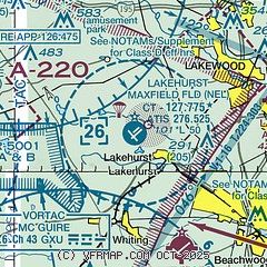
| Sectional chart |
|---|
|
 Download PDF
of official airport diagram from the FAA
| Airport distance calculator |
|---|
|
|
| Sunrise and sunset |
|---|
|
Times for 03-Dec-2025
| | Local
(UTC-5) | | Zulu
(UTC) |
|---|
| Morning civil twilight | | 06:33 | | 11:33 |
| Sunrise | | 07:03 | | 12:03 |
| Sunset | | 16:31 | | 21:31 |
| Evening civil twilight | | 17:01 | | 22:01 |
|
| Current date and time |
|---|
| Zulu (UTC) | 03-Dec-2025 09:13:04 |
|---|
| Local (UTC-5) | 03-Dec-2025 04:13:04 |
|---|
|
| METAR |
|---|
KMJX
7nm SE | AWOS-3 119.875 732-244-4450
030856Z AUTO 31006G17KT 10SM FEW027 00/M03 A2992 RMK AO2 SLP137 P0002 60009 T00001033 51039 FZRANO $
|
KWRI
11nm W | 030855Z AUTO 30009KT 10SM SCT028 01/M04 A2992 RMK AO2 SLP133 T00051042 52035
|
KBLM
13nm NE | AWOS-3 121.625 732-938-3330
030856Z AUTO 30014G21KT 10SM CLR 01/M02 A2990 RMK AO2 SLP125 T00061017 51035 FZRANO
|
|
| TAF |
|---|
KWRI
11nm W | 030400Z 0304/0408 32012G20KT 9999 OVC020 QNH2972INS BECMG 0309/0310 31010G15KT 9999 FEW015 QNH2992INS BECMG 0315/0316 26006KT 9999 FEW015 SCT150 QNH3003INS BECMG 0403/0404 26009KT 9999 SCT015 QNH3005INS TX06/0319Z TNM02/0309Z
|
|
| NOTAMs |
|---|
NOTAMs are issued by the DoD/FAA and will open in a separate window not controlled by AirNav.
|
|


