FAA INFORMATION EFFECTIVE 22 JANUARY 2026
Location
| FAA Identifier: | NK51 |
| Lat/Long: | 43-01-45.2410N 075-50-43.6840W
43-01.754017N 075-50.728067W
43.0292336,-75.8454678
(estimated) |
| Elevation: | 740 ft. / 226 m (estimated) |
| Variation: | 12W (1985) |
| From city: | 1 mile E of CHITTENANGO, NY |
| Time zone: | UTC -5 (UTC -4 during Daylight Saving Time) |
| Zip code: | 13037 |
Airport Operations
| Airport use: | Private use. Permission required prior to landing |
| Activation date: | 06/1948 |
| Control tower: | no |
| ARTCC: | BOSTON CENTER |
| FSS: | BUFFALO FLIGHT SERVICE STATION |
| Attendance: | UNATNDD |
| Wind indicator: | yes |
| Segmented circle: | no |
Airport Communications
| WX ASOS at SYR (12 nm NW): | PHONE 315-526-3244 |
| WX AWOS-3P at VGC (17 nm SE): | 119.425 (315-824-1825) |
Nearby radio navigation aids
| VOR radial/distance | | VOR name | | Freq | | Var |
|---|
| SYRr128/17.6 | | SYRACUSE VORTAC | | 117.00 | | 11W |
Airport Services
| Parking: | tiedowns |
| Airframe service: | NONE |
| Powerplant service: | NONE |
Runway Information
Runway 9/27
| Dimensions: | 1700 x 80 ft. / 518 x 24 m |
| Surface: | turf, in good condition |
| Runway edge markings: | NUMBERS BARELY VISIBLE IN GRASS |
| RUNWAY 9 | | RUNWAY 27 |
| Traffic pattern: | left | | left |
| Obstructions: | 30 ft. pline, marked, 95 ft. from runway, 63 ft. left of centerline, 3:1 slope to clear
UTILITY POLES/LINES CROSS RWY AT ANGLE - IS 315' FRM THLD AT CNTRLN | | 10 ft. brush, 13 ft. from runway, 1:1 slope to clear |
Runway 17/35
| Dimensions: | 1060 x 90 ft. / 323 x 27 m |
| Surface: | turf/L
GRASS NOT MOWED; 4FT TALL GRASS, BUSHES AND SAPLINGS ENTIRE LENGTH OF RY. |
| RUNWAY 17 | | RUNWAY 35 |
| Traffic pattern: | left | | left |
| Obstructions: | 50 ft. tree, 50 ft. from runway, 1:1 slope to clear | | 50 ft. tree, 20 ft. from runway |
Airport Ownership and Management from official FAA records
| Ownership: | Privately-owned |
| Owner: | MR. P. DEIERLEIN
6257 PERRYVILLE ROAD
CHITTENANGO, NY 13037
Phone 315-687-5456 |
| Manager: | MR. P. DEIERLEIN
6257 PERRYVILLE ROAD
CHITTENANGO, NY 13037
Phone 315-687-5456 |
Additional Remarks
| - | FOR CD CTC SYRACUSE APCH AT 315-455-6218. |
| - | FIRST 50' OF RY 35 DROPS OFF APRXLY 8'. |
| - | RY NOT ALWAYS PLOWED FOR WINTER OPNS; CALL 315-687-5456 FOR CONDITIONS. |
| - | RWY 17/35- CROSSWIND RWY NOT MOWED: 4 FT HIGH GRASS, BUSHES & SAPLINGS ENTIRE LENGTH OF RY. |
| - | RWY 9/27: MOWED CLEAR AREA 100' X 100' BEFORE EACH RWY BEG. |
| - | RWY 9: 2.5% UPSLOPE FIRST 400' OF RWY |
| - | RWY 9: +50'-80' TREES PENETRATE LAT. TRANS. SURF., 128'-305' NORTH OF CNTRLN, 225'-710' PAST THLD; +20-60' TREES PENETRATE LAT. TRANS. SURF., 40'-80' SOUTH OF CNTRLN, 0'-1300' PAST THLD |
| - | RWY 9: +40-85' TREES IN PRIM. SURF., 45'-75' NORTH OF CNTRLN, 700-800 PAST THLD |
| - | RY 27 HAS +24 FT UTILITY POLES/WIRES CROSS RY AT A SKEW. CLOSEST IS 104 FT R; 170 FT FM THLD; +21 FT TREE, 100 FT R 40 FT FM THLD. 12 FT DROP-OFF LOCATED 10 FT FM RY END. |
Instrument Procedures
There are no published instrument procedures at NK51.
Some nearby airports with instrument procedures:
KSYR - Syracuse Hancock International Airport (12 nm NW)
KVGC - Hamilton Municipal Airport (17 nm SE)
KRME - Griffiss International Airport (23 nm NE)
6B9 - Skaneateles Aero Drome (27 nm W)
B16 - Whitfords Airport (31 nm W)
|
|

Road maps at:
MapQuest
Bing
Google
| Aerial photo |
|---|

|
| Sectional chart |
|---|
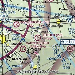
|
| Airport distance calculator |
|---|
|
|
| Sunrise and sunset |
|---|
|
Times for 07-Feb-2026
| | Local
(UTC-5) | | Zulu
(UTC) |
|---|
| Morning civil twilight | | 06:43 | | 11:43 |
| Sunrise | | 07:13 | | 12:13 |
| Sunset | | 17:23 | | 22:23 |
| Evening civil twilight | | 17:52 | | 22:52 |
|
| Current date and time |
|---|
| Zulu (UTC) | 07-Feb-2026 15:27:33 |
|---|
| Local (UTC-5) | 07-Feb-2026 10:27:33 |
|---|
|
| METAR |
|---|
KSYR
12nm NW | 071506Z 31020G29KT 1SM R28/3000VP6000FT -SN BLSN BKN015 M18/M22 A3001 RMK AO2 PK WND 30029/1500 P0000 T11831217 $
|
KVGC
17nm SE | 071515Z AUTO 31015G22KT 3SM HZ SCT018 SCT028 BKN035 M18/M25 A2986 RMK AO2
|
KRME
23nm NE | 071453Z 29017KT 4SM HZ BKN026 OVC090 M19/M25 A2996 RMK AO2 SLP153 60000 T11941250 51035 $
|
|
| TAF |
|---|
KSYR
12nm NW | 071120Z 0712/0812 31015G30KT 1SM -SHSN BLSN OVC015 FM071500 32020G30KT 3SM -SHSN BLSN BKN025 FM072300 32012KT P6SM BKN035 FM080600 33007G14KT P6SM BKN025
|
|
| NOTAMs |
|---|
NOTAMs are issued by the DoD/FAA and will open in a separate window not controlled by AirNav.
|
|

