FAA INFORMATION EFFECTIVE 12 JUNE 2025
Location
| FAA Identifier: | NRB |
| Lat/Long: | 30-23-28.9471N 081-25-28.2762W
30-23.482452N 081-25.471270W
30.3913742,-81.4245212
(estimated) |
| Elevation: | 14.8 ft. / 5 m (estimated) |
| Variation: | 06W (2015) |
| From city: | 1 mile NW of MAYPORT, FL |
| Time zone: | UTC -4 (UTC -5 during Standard Time) |
| Zip code: | 32227 |
Airport Operations
| Airport use: | Private use. Permission required prior to landing |
| Control tower: | yes |
| ARTCC: | JACKSONVILLE CENTER |
| FSS: | GAINESVILLE FLIGHT SERVICE STATION
FSS-GAINESVILLE GNV-NOTAM JAX. |
| NOTAMs facility: | NRB (NOTAM-D service available) |
| Attendance: | MON-THU 1300-0400Z (DT 1200-0400), ALL FRI 1300-2300Z
CLSD SAT, SUN & FEDERAL HOLS UNLESS OTRW NOTAM. |
| Segmented circle: | no |
| Lights: | AVBL DURG AFLD OPS HRS. |
| Beacon: | white-white-green (lighted military airport)
Operates sunset to sunrise. |
| International operations: | CUSTOMS/AGRICULTURE/IMG AVBL FOR ACFT WITH 30 PSGRS OR
LESS; MON-FRI EXCP HOLS 0800-1700. OTHER TIMES 48 HR
PPR. |
Airport Communications
| ATIS: | 236.775 |
| NAVY MAYPORT GROUND: | 126.5 233.7 [1300-0400Z (DT 1200-0400) MON-THU; 1300-2300Z++ FRI; CLSD SAT, SUN AND FEDERAL HOLS.] |
| NAVY MAYPORT TOWER: | 118.75 239.3 288.325X [1300-0400Z (DT 1200-0400) MON-THU; 1300-2300Z++ FRI; CLSD SAT, SUN AND FEDERAL HOLS.] |
| JACKSONVILLE APPROACH: | 124.9 |
| JACKSONVILLE DEPARTURE: | 124.9 |
| ALCRN STAR: | 127.0 |
| EMERG: | 121.5 243.0 |
| PMSV METRO: | 289.95 301.3 |
| PTD: | 308.5 |
| WX ASOS at CRG (6 nm SW): | 125.4 (904-646-4670) |
| WX AWOS-3 at FHB (13 nm N): | 118.075 (904-277-7323) |
| WX ASOS at JAX (15 nm NW): | 125.85 (904-549-9655) |
| WX AWOS-3 at NIP (16 nm SW): | 119.275 |
- NO NOTAM MAINTENANCE SCHEDULE: ASR/PAR 0700-1100 TUES.
- OT CTC NAVAL AVIATION FCST CENTER FO WX ADVSY OR WX FCST DSN564-2594,C757-444-2594.
Nearby radio navigation aids
| VOR radial/distance | | VOR name | | Freq | | Var |
|---|
| CRGr058/5.4 | | CRAIG VORTAC | | 114.50 | | 03W |
| SGJr355/26.5 | | ST AUGUSTINE VOR/DME | | 109.40 | | 06W |
| SSIr182/39.6 | | BRUNSWICK VORTAC | | 109.80 | | 04W |
| NDB name | | Hdg/Dist | | Freq | | Var | | ID |
|---|
| REYNOLDS | | 032/28.2 | | 338 | | 07W | | RYD | .-. -.-- -.. |
Airport Services
| Fuel available: | J5
J5:AFT HR FUEL NA; TSNT HEL HOT RFL CTC BASE OPS 904-270-6130/DSN 270-6130; COORD RFL TIMES HSM-40 ODO - 904-270-6332/DSN 960-6332 (DIAL 0 & REQ MAINT CTL); FIXED WING HOT RFL NA. |
| Airframe service: | NONE |
| Powerplant service: | NONE |
| Bottled oxygen: | NONE |
| Bulk oxygen: | NONE |
Runway Information
Runway 5/23
| Dimensions: | 8001 x 200 ft. / 2439 x 61 m |
| Surface: | asphalt, in good condition |
| Weight bearing capacity: | |
| Runway edge lights: | high intensity |
| RUNWAY 5 | | RUNWAY 23 |
| Latitude: | 30-22.999147N | | 30-23.965702N |
| Longitude: | 081-25.989590W | | 081-24.952695W |
| Elevation: | 10.8 ft. | | 11.9 ft. |
| Traffic pattern: | left | | right |
| Markings: | precision, in good condition | | precision, in good condition |
| Visual slope indicator: | 4-light PAPI on left (3.00 degrees glide path) | | 4-light PAPI on left (3.00 degrees glide path) |
| Runway end identifier lights: | yes | | yes |
| Touchdown point: | yes, no lights | | yes, no lights |
Airport Ownership and Management from official FAA records
| Ownership: | U.S. Navy |
| Owner: | US NAVY
OCEANOGRAPHIC OFC-CODE 3142
WASHINGTON, DC 20373 |
| Manager: | TEG MCNEAL
NAVAL AIR STATION
MAYPORT, FL 32228
Phone 904-270-7126 |
Additional Remarks
| E60-05 | HOOK E28(B) (1200 FT). 30 MIN NOTICE FOR ARSTMT UNLESS FLD IN DIV STS. |
| E60-23 | HOOK E28(B) (1186 FT). 30 MIN NOTICE FOR ARSTMT UNLESS FLD IN DIV STS. |
| - | JASU: 1(NC-8) 1(GTC-85) 1(A/NCPP-105). |
| - | MISC: CLASS D AIRSPACE AND CLASS E AIRSPACE 700 FT AND BELOW EFF 1200-0400Z++ (DT 1100-0400Z) SPECIAL LOCAL OPS 0400-0700Z++ MON-THU; 1300-2300Z++(DT 1200-2200Z) FRI; CLSD SAT, SUN, AND HOL. OTHER TIMES CLASS G AIRSPACE 700 FT AND BELOW. JACKSONVILLE CLASS E AIRSPACE 700 FT AND ABV EFF CONT. |
| - | CAUTION: EXP SIMUL SAME DRCTN OPS DURG DUAL RWY OPS. |
| - | FOR CD CTC JACKSONVILLE APCH AT 904-741-0284. |
| - | TRAN ALERT: GND TRANSPORTATION UNAVBL FOR AIRCREW OR PAX. |
| - | MISC: FOR CIV ACFT LDG PMT (CALP) REQ CTC AIRFIELD MGMT C904-445-8326. |
| - | FIRE EQUIP (PG4): 1500 GAL STRYKER (242) EQUIPPED WITH A 210 GAL FOAM TANK AND 500 LBS. OF HALON, 2-1250 GPM PUMPERS WITH 750 GALS OF WATER, 1-2000 GPM ARL APPARATUS WITH 500 GALS OF WATER, 1 ADVND LIFE SUPPORT TRNSP AMBULANCE, 1 HEAVY RSCU TRUCK WITH HAZMAT AND TECHNICAL RSCU RESP CAPABILITIES, 1 HAZMAT DECONTAMINATION TRAILER, 1 AIR CART FOR RE-FILLING AIR BOTTLES, 2 UTILITY TRUCKS, 1 COMMAN D VEHICLE. |
| - | ELECTRONIC MAINT (PG3): GND PWR UNITS: 12 EXTERNAL GND START UNITS (ALL PERM UNITS ON H-60 RAMP) |
| - | SNOW REMOVAL EQUIP (PG4): 1-15,000 LB FORKLIFT. |
| - | TSNT/HUNG ORDNANCE/DIVERT ALERT; ORGANIC AIR-LAUNCHED WEAPONS SAFING CPBLY NA; TSNT MAINT NA; LIMITED TSNT PRK AVBL. |
| - | RSTD: 24 HR PPR/CIVIL ACFT LNDG PERMIT; PCN EXCEEDING 34 RQR 72 HR PPR - BASE OPS DSN 270-6130/31, C904-270-6130/31. PARTICIPATING ACFT ONLY DURG SPL LCL OPS. |
| - | CAUTION: LGT TO HVY BIRD ACT ON AND IN VCNTY OF ARPT. VESSELS WITH MASTS TO 196 FT FQTLY BERTHED 800 FT LEFT OF RWY 23 THLD. LARGE VESSELS WITH MASTS UP TO 150 FT FQTLY TRANSIT THE RIVER CHAN ADJ TO APCH END RWY 23 DUR FINAL APCH. |
| - | CAUTION: EXER VIGILANCE DURG RWY 05 OPS DUE TO EXTSV CTLD/UNCTLD ACFT INVOF CRAIG MUNI ARPT. PADS 1 & 3 HAVE ALTERED LGT & APVD FOR LCL BASED ACFT ONLY. |
| - | TFC PAT: R TFC RWY 23 & L TFC RW 05. SIMULTANEOUS LDG/DEP BTN HEL CONDUCTED ON PARL TWY LCTD 325 FT FM RWY 05/23. |
| - | NS ABTMT: MAYPORT VILLAGE AND N BANK OF ST JOHNS RIVER ARE NOISE SENSITIVE. NO XW/BASE TURNS BTN TWY BRAVO-FOXTROT. |
| - | CSTMS/AG/IMG: AVBL DURG AFLD HRS WITH 24 HR PPR. |
Instrument Procedures
NOTE: All procedures below are presented as PDF files. If you need a reader for these files, you should download the free Adobe Reader.NOT FOR NAVIGATION. Please procure official charts for flight.
FAA instrument procedures published for use from 12 June 2025 at 0901Z to 10 July 2025 at 0900z.
STARs - Standard Terminal Arrivals |
|---|
| ALCRN ONE (RNAV) | |
download (153KB) |
| HOTAR ONE (RNAV) | |
download (226KB) |
| MARQO THREE (RNAV) | |
download (171KB) |
| POGIE TWO | |
download (168KB) |
| QUBEN TWO (RNAV) | |
download (162KB) |
| TEBOW TWO (RNAV) | |
download (132KB) |
IAPs - Instrument Approach Procedures |
|---|
| TACAN Y RWY 05 | |
download (148KB) |
| TACAN Y RWY 23 | |
download (139KB) |
| COPTER RNAV (GPS) RWY 05 | |
download (76KB) |
| COPTER RNAV (GPS) RWY 23 | |
download (71KB) |
| COPTER TACAN Z RWY 05 | |
download (123KB) |
| COPTER TACAN Z RWY 23 | |
download (127KB) |
| Radar Approach Procedures available | |
download (176KB) |
| NOTE: Special Take-Off Minimums/Departure Procedures apply | |
download (399KB) |
Other nearby airports with instrument procedures:
KCRG - Jacksonville Executive Airport at Craig (6 nm SW)
KFHB - Fernandina Beach Municipal Airport (13 nm N)
KJAX - Jacksonville International Airport (15 nm NW)
KNIP - Jacksonville Naval Air Station (Towers Field) (16 nm SW)
KHEG - Herlong Recreational Airport (21 nm W)
|
|

Road maps at:
MapQuest
Bing
Google
| Aerial photo |
|---|
WARNING: Photo may not be current or correct

Do you have a better or more recent aerial photo of Mayport Naval Station (Adm David L. McDonald Field) that you would like to share? If so, please send us your photo.
|
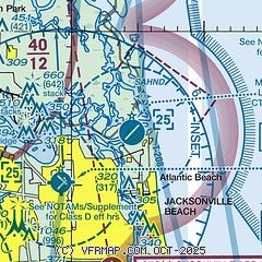
| Sectional chart |
|---|
|
 Download PDF
of official airport diagram from the FAA
| Airport distance calculator |
|---|
|
|
| Sunrise and sunset |
|---|
|
Times for 25-Jun-2025
| | Local
(UTC-4) | | Zulu
(UTC) |
|---|
| Morning civil twilight | | 05:59 | | 09:59 |
| Sunrise | | 06:26 | | 10:26 |
| Sunset | | 20:30 | | 00:30 |
| Evening civil twilight | | 20:58 | | 00:58 |
|
| Current date and time |
|---|
| Zulu (UTC) | 25-Jun-2025 20:50:47 |
|---|
| Local (UTC-4) | 25-Jun-2025 16:50:47 |
|---|
|
| METAR |
|---|
| KNRB | 251952Z 13009KT 10SM FEW040 BKN250 34/21 A3020 RMK SLP192 T03390211
|
KCRG
6nm SW | 251953Z 12006KT 10SM CLR 33/20 A3009 RMK AO2 SLP189 T03330200
|
KFHB
13nm N | 252035Z AUTO 15008KT CLR 31/21 A3009 RMK AO2 PWINO
|
KJAX
15nm NW | 251956Z 12007KT 10SM FEW055 BKN250 34/21 A3007 RMK AO2 SLP184 T03440211
|
KNIP
16nm SW | 251953Z 11004KT 10SM FEW045 SCT250 33/20 A3009 RMK SLP184 T03280200
|
|
| TAF |
|---|
| KNRB | 2515/2615 11010KT 9999 FEW040 BKN250 QNH3010INS FM251800 11010G15KT 9999 SCT040 BKN250 QNH3000INS FM260400 VRB05KT 9999 VCSH SCT040CB SCT250 QNH3002INS FM261100 22006KT 9999 BKN030 BKN250 QNH3004INS TX34/2518Z TN26/2611Z FN20022
|
KCRG
6nm SW | 251750Z 2518/2618 08007KT P6SM SCT070 BKN250 FM252000 11009KT P6SM SCT040 SCT250 FM260700 14006KT P6SM VCTS SCT035CB BKN120 BKN250 FM261000 00000KT P6SM FEW070 BKN250 FM261500 09006KT P6SM SCT050 BKN250
|
KJAX
15nm NW | 251750Z 2518/2618 VRB03KT P6SM FEW040 BKN060 BKN250 FM252000 11009KT P6SM SCT040 SCT250 FM260700 14006KT P6SM VCTS SCT035CB BKN120 BKN250 FM261100 00000KT P6SM FEW070 BKN250 FM261500 09006KT P6SM SCT050 BKN250
|
KNIP
16nm SW | 2515/2615 12006KT 9999 FEW050 SCT250 QNH3009INS FM251800 10010G15KT 9999 FEW050 BKN250 QNH3003INS FM260400 16008KT 9999 VCSH SCT060 BKN250 QNH3005INS FM261000 16006KT 9999 FEW060 SCT250 QNH3006INS TX33/2518Z TN25/2611Z FN20089
|
|
| NOTAMs |
|---|
NOTAMs are issued by the DoD/FAA and will open in a separate window not controlled by AirNav.
|
|


