FAA INFORMATION EFFECTIVE 22 JANUARY 2026
Location
| FAA Identifier: | OBE |
| Lat/Long: | 27-15-59.6650N 080-51-01.4080W
27-15.994417N 080-51.023467W
27.2665736,-80.8503911
(estimated) |
| Elevation: | 33.5 ft. / 10.2 m (surveyed) |
| Variation: | 06W (2010) |
| From city: | 3 miles NW of OKEECHOBEE, FL |
| Time zone: | UTC -5 (UTC -4 during Daylight Saving Time) |
| Zip code: | 34972 |
Airport Operations
| Airport use: | Open to the public |
| Activation date: | 04/1940 |
| Control tower: | no |
| ARTCC: | MIAMI CENTER |
| FSS: | SAINT PETERSBURG FLIGHT SERVICE STATION |
| NOTAMs facility: | PIE (NOTAM-D service available) |
| Attendance: | 0800-1700
UNATNDD CHRISTMAS AND THANKSGIVING.
AFT HRS CALL 863-657-8761 |
| Wind indicator: | lighted |
| Segmented circle: | yes |
| Lights: | ACTVT REIL RWY 05 & 23; MIRL RWY 05/23, - CTAF |
| Beacon: | white-green (lighted land airport)
Operates sunset to sunrise. |
Airport Communications
| CTAF/UNICOM: | 123.0 |
| WX AWOS-3: | 118.675 (863-467-1148) |
- APCH/DEP SVC PRVDD BY MIAMI ARTCC ON FREQS 132.25/370.9 (VERO BEACH RCAG).
Nearby radio navigation aids
| NDB name | | Hdg/Dist | | Freq | | Var | | ID |
|---|
| UNITED | | 313/34.9 | | 405 | | 05W | | UTX | ..- - -..- |
Airport Services
| Fuel available: | 100LL JET-A JET-A+ |
| Parking: | tiedowns |
| Airframe service: | MINOR |
| Powerplant service: | MINOR |
| Bottled oxygen: | NONE |
| Bulk oxygen: | NONE |
Runway Information
Runway 5/23
| Dimensions: | 5000 x 100 ft. / 1524 x 30 m |
| Surface: | asphalt, in excellent condition |
| Runway edge lights: | medium intensity |
| RUNWAY 5 | | RUNWAY 23 |
| Latitude: | 27-15.728700N | | 27-16.311917N |
| Longitude: | 080-51.321043W | | 080-50.667722W |
| Elevation: | 32.9 ft. | | 32.8 ft. |
| Traffic pattern: | left | | left |
| Runway heading: | 051 magnetic, 045 true | | 231 magnetic, 225 true |
| Markings: | nonprecision, in good condition | | nonprecision, in good condition |
| Visual slope indicator: | 4-light PAPI on left (3.00 degrees glide path) | | 4-light PAPI on left (3.00 degrees glide path) |
| Runway end identifier lights: | yes | | yes |
| Touchdown point: | yes, no lights | | yes, no lights |
| Obstructions: | 43 ft. trees, 1920 ft. from runway, 300 ft. left of centerline, 40:1 slope to clear | | 43 ft. trees, 1430 ft. from runway, 195 ft. left of centerline, 28:1 slope to clear |
Runway 14/32
| Dimensions: | 4001 x 75 ft. / 1220 x 23 m |
| Surface: | asphalt, in fair condition |
| RUNWAY 14 | | RUNWAY 32 |
| Latitude: | 27-16.195572N | | 27-15.728512N |
| Longitude: | 080-51.320977W | | 080-50.798643W |
| Elevation: | 33.0 ft. | | 32.3 ft. |
| Traffic pattern: | left | | left |
| Runway heading: | 141 magnetic, 135 true | | 321 magnetic, 315 true |
| Markings: | nonprecision, in fair condition | | nonprecision, in fair condition |
| Visual slope indicator: | 4-light PAPI on left (3.00 degrees glide path) | | 4-light PAPI on left (3.00 degrees glide path) |
| Runway end identifier lights: | no | | no |
| Touchdown point: | yes, no lights | | yes, no lights |
| Obstructions: | 34 ft. trees, 1060 ft. from runway, 175 ft. left of centerline, 25:1 slope to clear
CTLG OBSTN EXCEEDS A 45 DEG SLP. | | 5 ft. fence, lighted, 200 ft. from runway, 215 ft. left of centerline
5 FT FENCE 200FT FM RWY END 215 FT L. |
Airport Ownership and Management from official FAA records
| Ownership: | Publicly-owned |
| Owner: | OKEECHOBEE COUNTY
2800 NW 20TH TRL
OKEECHOBEE, FL 34972
Phone 863-763-6441
CONTACT PERSON: DEBORAH MANZO 863-763-6441 |
| Manager: | CHRISTOPHER GEORGES
2800 NW 20TH TRL
OKEECHOBEE, FL 34972
Phone 863-467-5505
EMERGENCY CELL PHONE 863-634-1474 |
Additional Remarks
| A39-05/23 | PCR VALUE: 218/F/A/X/T |
| A39-14/32 | PCR VALUE: 192/F/A/X/T |
| A30A-05 | CALM WIND RWY. |
| - | FBO PHONE IS 863-467-5505. |
| - | NON-POWERED FLT WI TFC PAT NA. |
| - | TKOF & LNDG ON GRASS AT OWN RISK. |
| - | FOR CD CTC MIAMI ARTCC AT 305-716-1731. |
| - | APRON PCR VALUE: 203/F/A/X/T |
| - | TWY A PCR VALUE: 378/F/A/X/T |
Instrument Procedures
NOTE: All procedures below are presented as PDF files. If you need a reader for these files, you should download the free Adobe Reader.NOT FOR NAVIGATION. Please procure official charts for flight.
FAA instrument procedures published for use from 22 January 2026 at 0901Z to 19 February 2026 at 0900z.
IAPs - Instrument Approach Procedures |
|---|
| RNAV (GPS) RWY 05 **CHANGED** | |
download (198KB) |
| RNAV (GPS) RWY 14 **CHANGED** | |
download (172KB) |
| RNAV (GPS) RWY 23 **CHANGED** | |
download (237KB) |
| RNAV (GPS) RWY 32 **CHANGED** | |
download (204KB) |
| NOTE: Special Alternate Minimums apply | |
download (21KB) |
Other nearby airports with instrument procedures:
KSEF - Sebring Regional Airport (29 nm NW)
KFPR - Treasure Coast International Airport (29 nm NE)
KPHK - Palm Beach County Glades Airport (30 nm S)
KVRB - Vero Beach Regional Airport (33 nm NE)
2IS - Airglades Airport (34 nm S)
|
|

Road maps at:
MapQuest
Bing
Google
| Aerial photo |
|---|
WARNING: Photo may not be current or correct
 Photo by Stephen Blank, DDS
Photo taken 27-Jan-2017
looking northeast.
Photo by Stephen Blank, DDS
Photo taken 27-Jan-2017
looking northeast.
Do you have a better or more recent aerial photo of Okeechobee County Airport that you would like to share? If so, please send us your photo.
|
| Sectional chart |
|---|
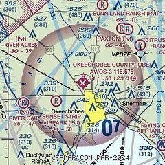
|
CAUTION: Diagram may not be current

| Airport distance calculator |
|---|
|
|
| Sunrise and sunset |
|---|
|
Times for 09-Feb-2026
| | Local
(UTC-5) | | Zulu
(UTC) |
|---|
| Morning civil twilight | | 06:42 | | 11:42 |
| Sunrise | | 07:06 | | 12:06 |
| Sunset | | 18:10 | | 23:10 |
| Evening civil twilight | | 18:34 | | 23:34 |
|
| Current date and time |
|---|
| Zulu (UTC) | 09-Feb-2026 08:37:06 |
|---|
| Local (UTC-5) | 09-Feb-2026 03:37:06 |
|---|
|
| METAR |
|---|
| KOBE | 090815Z AUTO 00000KT 10SM CLR 07/07 A3021 RMK AO2
|
|
| TAF |
|---|
KFPR
29nm NE | 090520Z 0906/1006 VRB03KT P6SM FEW150 TEMPO 0909/0913 5SM BR SCT009 FM091600 10007KT P6SM FEW035 FM100000 VRB03KT P6SM FEW050 FEW140
|
KVRB
33nm NE | 090708Z 0907/1006 VRB03KT P6SM FEW150 TEMPO 0907/0911 3SM BR SCT009 FM091600 09008KT P6SM FEW035 FM100000 VRB04KT P6SM FEW050 FEW140
|
KSUA
34nm E | 090520Z 0906/1006 VRB03KT P6SM FEW150 FM091600 09007KT P6SM FEW035 FM100000 VRB03KT P6SM FEW050 FEW140 AMD NOT SKED
|
|
| NOTAMs |
|---|
NOTAMs are issued by the DoD/FAA and will open in a separate window not controlled by AirNav.
|
|


