FAA INFORMATION EFFECTIVE 27 NOVEMBER 2025
Location
| FAA Identifier: | ONP |
| Lat/Long: | 44-34-49.3000N 124-03-28.5000W
44-34.821667N 124-03.475000W
44.5803611,-124.0579167
(estimated) |
| Elevation: | 160.1 ft. / 48.8 m (surveyed) |
| Variation: | 15E (2020) |
| From city: | 3 miles S of NEWPORT, OR |
| Time zone: | UTC -8 (UTC -7 during Daylight Saving Time) |
| Zip code: | 97366 |
Airport Operations
| Airport use: | Open to the public |
| Activation date: | 03/1945 |
| Control tower: | no |
| ARTCC: | SEATTLE CENTER |
| FSS: | MC MINNVILLE FLIGHT SERVICE STATION |
| NOTAMs facility: | ONP (NOTAM-D service available) |
| Attendance: | 0800-1700 |
| Wind indicator: | lighted |
| Segmented circle: | yes |
| Lights: | ACTVT MALSR RWY 16; MIRL RYS 02/20 & HIRL 16/34 AND PAPIS RWY 16 & RWY 34 AND REIL RY 34 - CTAF. |
| Beacon: | white-green (lighted land airport) |
| Airline operations: | PPR FOR ACR OPNS WITH MORE THAN 30 PSGR SEATS CALL AMGR 541-867-7422. |
Airport Communications
| CTAF/UNICOM: | 122.8 |
| WX AWOS-3: | 133.9 (541-867-4175) |
- APCH/DEP CTL SVC PRVDD BY SEATTLE ARTCC (ZSE)ON FREQS 125.8/291.7 (HORTON RCAG).
Nearby radio navigation aids
| VOR radial/distance | | VOR name | | Freq | | Var |
|---|
| ONP at field | | NEWPORT VORTAC | | 117.10 | | 15E |
| CVOr260/33.0 | | CORVALLIS VOR/DME | | 115.40 | | 18E |
Airport Services
| Fuel available: | 100LL JET-A
100LL:FOR FUEL AFT HRS CALL 541-867-7422 OR 541-530-1364. |
| Parking: | hangars and tiedowns |
| Bottled oxygen: | NONE |
| Bulk oxygen: | NONE |
Runway Information
Runway 16/34
| Dimensions: | 5398 x 100 ft. / 1645 x 30 m |
| Surface: | asphalt, in good condition |
| Weight bearing capacity: | | PCN 34 /F/D/X/T | | Single wheel: | 75.0 | | Double wheel: | 120.0 | | Double tandem: | 170.0 |
|
| Runway edge lights: | high intensity |
| RUNWAY 16 | | RUNWAY 34 |
| Latitude: | 44-35.210640N | | 44-34.323228N |
| Longitude: | 124-03.562250W | | 124-03.504225W |
| Elevation: | 152.1 ft. | | 158.8 ft. |
| Traffic pattern: | right | | left |
| Runway heading: | 162 magnetic, 177 true | | 342 magnetic, 357 true |
| Displaced threshold: | no | | 300 ft. |
| Declared distances: | TORA:5398 TODA:5398 ASDA:5398 LDA:5398 | | TORA:5398 TODA:5398 ASDA:5398 LDA:5098 |
| Markings: | precision, in fair condition | | precision, in fair condition |
| Visual slope indicator: | 4-light PAPI on left (3.00 degrees glide path) | | 4-light PAPI on left (3.00 degrees glide path)
RWY 34 PAPI BEYOND 3DEG LEFT AND 5DEG RIGHT OF RCL UNUSABLE |
| Approach lights: | MALSR: 1,400 foot medium intensity approach lighting system with runway alignment indicator lights | | |
| Runway end identifier lights: | no | | yes |
| Touchdown point: | yes, no lights | | yes, no lights |
| Instrument approach: | ILS | | |
| Obstructions: | 24 ft. trees, 356 ft. from runway, 450 ft. left of centerline, 6:1 slope to clear | | 25 ft. trees, 467 ft. from runway, 10:1 slope to clear |
Runway 2/20
| Dimensions: | 3001 x 75 ft. / 915 x 23 m |
| Surface: | asphalt, in good condition |
| Weight bearing capacity: | | Single wheel: | 33.0 | | Double wheel: | 50.0 | | Double tandem: | 84.0 |
|
| Runway edge lights: | medium intensity |
| RUNWAY 2 | | RUNWAY 20 |
| Latitude: | 44-34.724210N | | 44-35.116862N |
| Longitude: | 124-03.578733W | | 124-03.159775W |
| Elevation: | 130.0 ft. | | 160.1 ft. |
| Traffic pattern: | left | | right |
| Runway heading: | 022 magnetic, 037 true | | 202 magnetic, 217 true |
| Declared distances: | TORA:3001 TODA:3001 ASDA:3001 LDA:3001 | | TORA:3001 TODA:3001 ASDA:3001 LDA:3001 |
| Markings: | basic, in fair condition | | basic, in fair condition |
| Touchdown point: | yes, no lights | | yes, no lights |
| Obstructions: | 17 ft. gnd, 875 ft. from runway, 300 ft. right of centerline, 39:1 slope to clear | | 67 ft. tree, 1085 ft. from runway, 100 ft. right of centerline, 13:1 slope to clear |
Airport Ownership and Management from official FAA records
| Ownership: | Publicly-owned |
| Owner: | CITY OF NEWPORT
169 SW COAST HWY
NEWPORT, OR 97365
Phone 541-574-0603 |
| Manager: | LANCE VANDERBECK
135 SE 84TH
NEWPORT, OR 97365
Phone (541) 867-7422 |
Additional Remarks
| - | BIRDS, DEER & COYOTES ON AND INVOF ARPT. |
| - | FOR CD IF UNA TO CTC ON FSS FREQ, CTC SEATTLE ARTCC AT 253-351-3694. |
| - | PILOTS CONDUCTING EFVS OPS; BE AWARE LED ALS IN USE RWY 16. |
Instrument Procedures
NOTE: All procedures below are presented as PDF files. If you need a reader for these files, you should download the free Adobe Reader.NOT FOR NAVIGATION. Please procure official charts for flight.
FAA instrument procedures published for use from 27 November 2025 at 0901Z to 25 December 2025 at 0900Z.
IAPs - Instrument Approach Procedures |
|---|
| ILS OR LOC RWY 16 | |
download (324KB) |
| RNAV (GPS) RWY 16 | |
download (307KB) |
| RNAV (GPS) RWY 34 | |
download (193KB) |
| VOR-A | |
download (163KB) |
| NOTE: Special Alternate Minimums apply | |
download (175KB) |
|
|---|
| NEWPORT ONE (OBSTACLE) | |
download (413KB) |
| NOTE: Special Take-Off Minimums/Departure Procedures apply | |
download (341KB) |
Other nearby airports with instrument procedures:
KCVO - Corvallis Municipal Airport (33 nm E)
S12 - Albany Municipal Airport (43 nm E)
KEUG - Mahlon Sweet Field Airport (45 nm SE)
KSLE - McNary Field Airport (49 nm NE)
KTMK - Tillamook Airport (51 nm N)
|
|

Road maps at:
MapQuest
Bing
Google
| Aerial photo |
|---|
WARNING: Photo may not be current or correct
 Photo by Jerry Wilken
Photo taken 22-Jun-2010
Photo by Jerry Wilken
Photo taken 22-Jun-2010
Do you have a better or more recent aerial photo of Newport Municipal Airport that you would like to share? If so, please send us your photo.
|
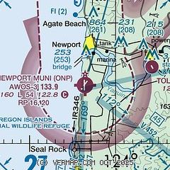
| Sectional chart |
|---|
|
| Airport distance calculator |
|---|
|
|
| Sunrise and sunset |
|---|
|
Times for 18-Dec-2025
| | Local
(UTC-8) | | Zulu
(UTC) |
|---|
| Morning civil twilight | | 07:16 | | 15:16 |
| Sunrise | | 07:49 | | 15:49 |
| Sunset | | 16:37 | | 00:37 |
| Evening civil twilight | | 17:10 | | 01:10 |
|
| Current date and time |
|---|
| Zulu (UTC) | 18-Dec-2025 09:56:01 |
|---|
| Local (UTC-8) | 18-Dec-2025 01:56:01 |
|---|
|
| METAR |
|---|
| KONP | 180935Z AUTO 10SM -RA SCT060 BKN070 OVC080 07/05 A3004 RMK AO2
|
|
| TAF |
|---|
| KONP | 180536Z 1806/1906 19008KT P6SM OVC050 FM180900 16012G22KT 5SM RA BR OVC020 FM181500 19023G46KT 2SM RA BR SCT005 OVC011 WS020/20050KT FM181800 20027G51KT 1 1/2SM +RA BR SCT005 OVC009 WS020/22060KT FM190000 23019G40KT 3SM +RA BR OVC008
|
|
| NOTAMs |
|---|
NOTAMs are issued by the DoD/FAA and will open in a separate window not controlled by AirNav.
|
|

