FAA INFORMATION EFFECTIVE 09 JULY 2026
Location
| FAA Identifier: | ONY |
| Lat/Long: | 33-21-03.2000N 098-49-09.0000W
33-21.053333N 098-49.150000W
33.3508889,-98.8191667
(estimated) |
| Elevation: | 1275.4 ft. / 388.7 m (surveyed) |
| Variation: | 05E (2015) |
| From city: | 3 miles SW of OLNEY, TX |
| Time zone: | UTC -5 (UTC -6 during Standard Time) |
| Zip code: | 76374 |
Airport Operations
| Airport use: | Open to the public |
| Activation date: | 05/1944 |
| Control tower: | no |
| ARTCC: | FORT WORTH CENTER |
| FSS: | FORT WORTH FLIGHT SERVICE STATION |
| NOTAMs facility: | FTW (NOTAM-D service available) |
| Attendance: | M-F 0800-1700 |
| Wind indicator: | yes |
| Segmented circle: | yes |
| Lights: | MIRL RWY 17/35 PRESET TO LOW INTST, TO INCR INTST ACTV - CTAF. |
| Beacon: | white-green (lighted land airport)
Operates sunset to sunrise. |
Airport Communications
| CTAF/UNICOM: | 122.8 |
| WX AWOS-3P at RPH (20 nm SE): | 118.025 (940-521-0685) |
- APCH/DEP SVC PRVDD BY FORT WORTH ARTCC (ZFW) ON FREQS 133.5/350.35 (WICHITA FALLS RCAG).
Nearby radio navigation aids
| VOR radial/distance | | VOR name | | Freq | | Var |
|---|
| SPSr186/39.8 | | WICHITA FALLS VORTAC | | 112.70 | | 10E |
Airport Services
| Fuel available: | 100LL
100LL:SELF SVC FUEL AVBL. |
| Parking: | tiedowns |
| Airframe service: | NONE |
| Powerplant service: | NONE |
| Bottled oxygen: | NONE |
| Bulk oxygen: | NONE |
Runway Information
Runway 17/35
| Dimensions: | 5101 x 75 ft. / 1555 x 23 m |
| Surface: | asphalt/rubberized friction seal coat, in fair condition |
| Weight bearing capacity: | | Single wheel: | 43.0 | | Double wheel: | 50.0 | | Double tandem: | 84.0 |
|
| Runway edge lights: | medium intensity |
| RUNWAY 17 | | RUNWAY 35 |
| Latitude: | 33-21.473758N | | 33-20.632695N |
| Longitude: | 098-49.213943W | | 098-49.219137W |
| Elevation: | 1275.3 ft. | | 1260.8 ft. |
| Traffic pattern: | left | | left |
| Runway heading: | 175 magnetic, 180 true | | 355 magnetic, 000 true |
| Markings: | nonprecision, in fair condition | | nonprecision, in fair condition |
| Visual slope indicator: | 2-box VASI on left (3.00 degrees glide path) | | 2-box VASI on right (3.00 degrees glide path) |
| Touchdown point: | yes, no lights | | yes, no lights |
| Obstructions: | 22 ft. trees, 574 ft. from runway, 19 ft. right of centerline, 17:1 slope to clear | | 15 ft. road, 575 ft. from runway, 25:1 slope to clear |
Runway 4/22
| Dimensions: | 5100 x 75 ft. / 1554 x 23 m |
| Surface: | asphalt/rubberized friction seal coat, in good condition |
| Weight bearing capacity: | | Single wheel: | 43.0 | | Double wheel: | 50.0 | | Double tandem: | 84.0 |
|
| RUNWAY 4 | | RUNWAY 22 |
| Latitude: | 33-20.896750N | | 33-21.488215N |
| Longitude: | 098-49.471770W | | 098-48.759452W |
| Elevation: | 1264.4 ft. | | 1269.3 ft. |
| Traffic pattern: | left | | left |
| Runway heading: | 040 magnetic, 045 true | | 220 magnetic, 225 true |
| Markings: | basic, in fair condition | | basic, in fair condition |
| Touchdown point: | yes, no lights | | yes, no lights |
| Obstructions: | 16 ft. trees, 746 ft. from runway, 250 ft. left of centerline, 34:1 slope to clear | | 50 ft. pline, 2125 ft. from runway, 38:1 slope to clear |
Runway 13/31
| Dimensions: | 5099 x 75 ft. / 1554 x 23 m |
| Surface: | asphalt/L
FIRST THIRD AND LAST THIRD OF RWY EXTSV CRACKS W/VEGETATION GROWING THROUGH. LOOSE STONES. |
| Weight bearing capacity: | | Single wheel: | 43.0 | | Double wheel: | 50.0 | | Double tandem: | 84.0 |
|
| RUNWAY 13 | | RUNWAY 31 |
| Latitude: | 33-21.211507N | | 33-20.613885N |
| Longitude: | 098-49.469795W | | 098-48.765347W |
| Elevation: | 1271.1 ft. | | 1242.5 ft. |
| Traffic pattern: | left | | left |
| Runway heading: | 130 magnetic, 135 true | | 310 magnetic, 315 true |
| Markings: | numbers only, in poor condition | | numbers only, in poor condition |
| Touchdown point: | yes, no lights | | yes, no lights |
| Obstructions: | 15 ft. road, 700 ft. from runway, 175 ft. right of centerline, 33:1 slope to clear | | 15 ft. road, 410 ft. from runway, 250 ft. left of centerline, 14:1 slope to clear |
Airport Ownership and Management from official FAA records
| Ownership: | Publicly-owned |
| Owner: | CITY OF OLNEY
201 EAST MAIN
OLNEY, TX 76374
Phone 940-564-2102 |
| Manager: | JIM HIRSCH
PO BOX 485, 1524 LELAND SNOW WAY
OLNEY, TX 76374
Phone 940-564-5616
940-250-9121 AMGR CELL. |
Additional Remarks
| - | OCNL AERIAL AG OPNS |
| - | RWY 13/31 CNTR 1600 FT BY 75 FT OVERLAID WITH NO GRASS ENCROACHMENT. |
| - | FOR CD CTC FORT WORTH ARTCC AT 817-858-7584. |
Instrument Procedures
NOTE: All procedures below are presented as PDF files. If you need a reader for these files, you should download the free Adobe Reader.NOT FOR NAVIGATION. Please procure official charts for flight.
FAA instrument procedures published for use from 09 July 2026 at 0901Z to 06 August 2026 at 0900Z.
IAPs - Instrument Approach Procedures |
|---|
| RNAV (GPS) RWY 17 | |
download (223KB) |
| RNAV (GPS) RWY 35 | |
download (203KB) |
| NOTE: Special Take-Off Minimums/Departure Procedures apply | |
download (113KB) |
Other nearby airports with instrument procedures:
KRPH - Graham Municipal Airport (20 nm SE)
60F - Seymour Municipal Airport (28 nm NW)
F35 - Possum Kingdom Airport (32 nm SE)
KCWC - Kickapoo Downtown Airport (35 nm NE)
F14 - Wichita Valley Airport (37 nm N)
|
|

Road maps at:
MapQuest
Bing
Google
| Aerial photo |
|---|
WARNING: Photo may not be current or correct
 Photo taken 18-Jan-2016
Do you have a better or more recent aerial photo of Olney Municipal Airport that you would like to share? If so, please send us your photo.
|
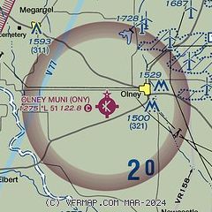
| Sectional chart |
|---|
|
CAUTION: Diagram may not be current

| Airport distance calculator |
|---|
|
|
| Sunrise and sunset |
|---|
|
Times for 13-Jul-2026
| | Local
(UTC-5) | | Zulu
(UTC) |
|---|
| Morning civil twilight | | 06:08 | | 11:08 |
| Sunrise | | 06:36 | | 11:36 |
| Sunset | | 20:45 | | 01:45 |
| Evening civil twilight | | 21:14 | | 02:14 |
|
| Current date and time |
|---|
| Zulu (UTC) | 13-Jul-2026 19:38:16 |
|---|
| Local (UTC-5) | 13-Jul-2026 14:38:16 |
|---|
|
| METAR |
|---|
KRPH
20nm SE | 131915Z AUTO 11004KT 10SM FEW039 32/20 A3007 RMK AO2 T03180205 $
|
KCWC
35nm NE | 131907Z AUTO 07006KT 10SM SCT040 SCT050 32/20 A3011 RMK AO2 PWINO
|
KBKD
38nm S | 131915Z AUTO 00000KT 10SM SCT035 SCT060 SCT080 32/22 A3009 RMK AO2 T03230217
|
|
| TAF |
|---|
KSPS
41nm NE | 131720Z 1318/1418 07010KT P6SM SCT040 PROB30 1318/1324 5SM -TSRA BKN030CB FM140100 10005KT P6SM FEW040 FM141100 08008KT 5SM BR BKN020
|
|
| NOTAMs |
|---|
NOTAMs are issued by the DoD/FAA and will open in a separate window not controlled by AirNav.
|
|


