FAA INFORMATION EFFECTIVE 16 APRIL 2026
Location
| FAA Identifier: | BLG |
| Lat/Long: | 61-10-22.6628N 151-02-43.4987W
61-10.377713N 151-02.724978W
61.1729619,-151.0454163
(estimated) |
| Elevation: | 87.2 ft. / 27 m (estimated) |
| Variation: | 19E (2010) |
| From city: | 8 SM NE TYONEK. |
| Time zone: | UTC -8 (UTC -9 during Standard Time) |
| Zip code: | 99688 |
Airport Operations
| Airport use: | Private use. Permission required prior to landing |
| Activation date: | 07/1962 |
| Control tower: | no |
| ARTCC: | ANCHORAGE CENTER |
| FSS: | KENAI FLIGHT SERVICE STATION [907-283-7211] |
| Attendance: | CONTINUOUS |
| Wind indicator: | yes |
| Segmented circle: | no |
| Lights: | ACTVT MIRL RWY 01/19 & 09/27 - CTAF. |
Airport Communications
Nearby radio navigation aids
| VOR radial/distance | | VOR name | | Freq | | Var |
|---|
| TEDr253/31.4 | | ANCHORAGE VOR/DME | | 113.15 | | 18E |
| ENAr348/33.8 | | KENAI VOR/DME | | 117.60 | | 19E |
| BGQr213/39.1 | | BIG LAKE VORTAC | | 112.50 | | 19E |
Airport Services
Runway Information
Helipad H1
| Dimensions: | 60 x 60 ft. / 18 x 18 m |
| Surface: | concrete |
| Latitude: | 61-10.664667N | | |
| Longitude: | 151-02.157500W | | |
| Elevation: | 79.0 ft. | | |
| Traffic pattern: | left | | left |
Runway 1/19
| Dimensions: | 5002 x 100 ft. / 1525 x 30 m |
| Surface: | gravel, in good condition
FIRST 200 FT RWY 19 SOFT & UNSTBL. |
| Runway edge lights: | medium intensity |
| RUNWAY 1 | | RUNWAY 19 |
| Latitude: | 61-10.003333N | | 61-10.724333N |
| Longitude: | 151-02.981167W | | 151-02.168333W |
| Elevation: | 76.3 ft. | | 71.0 ft. |
| Traffic pattern: | left | | left |
| Runway heading: | 010 magnetic, 029 true | | 190 magnetic, 209 true |
| Runway end identifier lights: | no | | no |
| Touchdown point: | yes, no lights | | yes, no lights |
| Obstructions: | trees, 100 ft. from runway, 20:1 slope to clear | | trees, 100 ft. from runway, 12:1 slope to clear |
Runway 9/27
| Dimensions: | 2505 x 60 ft. / 764 x 18 m |
| Surface: | gravel |
| Runway edge lights: | medium intensity |
| Operational restrictions: | NOT MNTND IN WINTER. |
| RUNWAY 9 | | RUNWAY 27 |
| Latitude: | 61-10.468833N | | 61-10.342000N |
| Longitude: | 151-03.429667W | | 151-02.620000W |
| Elevation: | 86.7 ft. | | 73.9 ft. |
| Traffic pattern: | left | | left |
| Runway heading: | 089 magnetic, 108 true | | 269 magnetic, 288 true |
| Touchdown point: | yes, no lights | | yes, no lights |
Airport Ownership and Management from official FAA records
| Ownership: | Privately-owned |
| Owner: | HILCORP ALASKA, LLC
3800 CENTERPOINT DR., STE 1400
ANCHORAGE, AK 99503
Phone 907-777-8300 |
| Manager: | HILCORP ALASKA, LLC
3800 CENTERPOINT DR., STE 1400
ANCHORAGE, AK 99503
Phone 907-777-8300 |
Additional Remarks
| A30A-19 | ROAD XS ADJ TO N END. BRUSH HINDERS VEHICLES FM SEEING ARR ON APCH END. |
| - | GTR THAN 20000 LB & ALL LDG OPS PPR - 907-263-3930/907-263-3910. |
| - | SHOULDER ON W & N SIDE OF RWYS SOGGY. |
| - | UNCTLD VEHICLE OPS ON ROAD ALG E SIDE OF RWYS. |
| - | WILDLIFE ON & INVOF ARPT. |
| - | W SIDE OF TWY SHOULDER NA BYD RWY EDGE LGTS. |
| - | RWYS NOT VISIBLE BY PSNL. |
| - | WX CAMERA AVBL ON INTERNET AT HTTPS://WEATHERCAMS.FAA.GOV |
Instrument Procedures
There are no published instrument procedures at PABG.
Some nearby airports with instrument procedures:
PANC - Ted Stevens Anchorage International Airport (30 nm E)
PAMR - Merrill Field Airport (35 nm E)
PAED - Elmendorf Air Force Base (36 nm E)
PAEN - Kenai Municipal Airport (36 nm S)
PAFR - Bryant Army Airfield (41 nm E)
|
|

Road maps at:
MapQuest
Bing
Google
| Aerial photo |
|---|
WARNING: Photo may not be current or correct
 Photo by Security Aviation
Photo taken 18-Oct-2018
looking north.
Photo by Security Aviation
Photo taken 18-Oct-2018
looking north.
Do you have a better or more recent aerial photo of Beluga Airport that you would like to share? If so, please send us your photo.
|
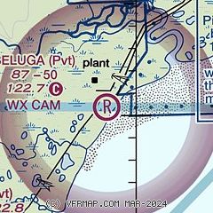
| Sectional chart |
|---|
|
| Airport distance calculator |
|---|
|
|
| Sunrise and sunset |
|---|
|
Times for 08-May-2026
| | Local
(UTC-8) | | Zulu
(UTC) |
|---|
| Morning civil twilight | | 04:33 | | 12:33 |
| Sunrise | | 05:36 | | 13:36 |
| Sunset | | 22:25 | | 06:25 |
| Evening civil twilight | | 23:28 | | 07:28 |
|
| Current date and time |
|---|
| Zulu (UTC) | 08-May-2026 17:57:34 |
|---|
| Local (UTC-8) | 08-May-2026 09:57:34 |
|---|
|
| METAR |
|---|
PANC
30nm E | 081753Z 03008KT 10SM FEW070 OVC100 06/01 A2977 RMK AO2 SLP082 T00610006 10067 20033 58019
|
PALH
31nm E | 081753Z AUTO 01008KT 10SM FEW070 OVC110 06/00 A2978 RMK AO2 SLP084 T00610000 10067 20022 58016 TSNO
|
PAMR
35nm E | 081753Z 33006KT 10SM BKN110 06/00 A2977 RMK AO2 SLP081 T00560000 10061 20039 58016
|
PAED
36nm E | 081655Z 01007KT 10SM SCT035 BKN055 05/01 A2977 RMK AO2A SLP078 SH NW MOV NW T00510005 $
|
PAEN
37nm S | 081753Z 36006KT 10SM OVC120 05/01 A2977 RMK AO2 SLP083 T00500011 10056 20000 58017
|
PAFR
41nm E | 081655Z AUTO 01008KT 10SM BKN044 OVC060 06/01 A2978 RMK AO2 SLP088 T00560006 $
|
PASX
41nm S | 081656Z AUTO 00000KT 10SM SCT065 OVC120 04/03 A2979 RMK AO2 SLP095 T00440033 TSNO
|
PABV
46nm E | 081656Z AUTO 21004KT 10SM OVC037 05/00 A2982 RMK AO2 SLP097 T00500000 $
|
|
| TAF |
|---|
PANC
30nm E | 081133Z 0812/0918 16011KT P6SM OVC060 FM081900 35006KT P6SM SCT025 OVC060 FM090300 15007KT P6SM OVC060 FM090700 30004KT P6SM -RA OVC030
|
PAED
36nm E | 080500Z 0805/0911 32006KT 9999 SCT055 BKN070 620703 QNH2991INS BECMG 0906/0907 36006KT 9999 -SHRA SCT040 BKN050 OVC080 620505 QNH2942INS TX11/0904Z TN04/0811Z
|
PAEN
37nm S | 081133Z 0812/0912 21006KT P6SM FEW030 OVC050 TEMPO 0814/0818 OVC030 FM082000 36010KT P6SM OVC050 FM090400 02006KT P6SM -RA OVC025
|
|
| NOTAMs |
|---|
NOTAMs are issued by the DoD/FAA and will open in a separate window not controlled by AirNav.
|
|

