FAA INFORMATION EFFECTIVE 09 JULY 2026
Location
| FAA Identifier: | BCV |
| Lat/Long: | 61-24-57.9150N 149-30-29.9152W
61-24.965250N 149-30.498587W
61.4160875,-149.5083098
(estimated) |
| Elevation: | 83 ft. / 25.3 m (surveyed) |
| Variation: | 19E (2010) |
| From city: | 2 miles NW of BIRCHWOOD, AK |
| Time zone: | UTC -8 (UTC -9 during Standard Time) |
| Zip code: | 99567 |
Airport Operations
| Airport use: | Open to the public |
| Activation date: | 10/1949 |
| Control tower: | no |
| ARTCC: | ANCHORAGE CENTER |
| FSS: | KENAI FLIGHT SERVICE STATION [907-283-7211] |
| NOTAMs facility: | BCV (NOTAM-D service available) |
| Attendance: | UNATNDD |
| Wind indicator: | lighted |
| Segmented circle: | yes |
| Lights: | ACTVT VASI RWY 20R; MIRL RWY 02L/20R - CTAF. ACTVT VASI RWY 20R - 7 CLICKS. |
| Beacon: | white-green (lighted land airport)
Operates sunset to sunrise. |
Airport Communications
| CTAF: | 123.0 |
| WX AWOS-3P: | 135.55 (907-621-7605) |
| WX AWOS-3P at IYS (9 nm N): | 135.25 (907-373-3801) |
| WX ASOS at FRN (10 nm SW): | 134.25 |
| WX ASOS at MRI (16 nm SW): | 124.25 (907-271-5277) |
| WX ASOS at PAQ (16 nm NE): | 134.75 (907-560-7680) |
| WX ASOS at LHD (19 nm SW): | 125.6 (907-245-5432) |
Nearby radio navigation aids
| VOR radial/distance | | VOR name | | Freq | | Var |
|---|
| BGQr106/16.0 | | BIG LAKE VORTAC | | 112.50 | | 19E |
| TEDr023/19.8 | | ANCHORAGE VOR/DME | | 113.15 | | 18E |
Airport Services
| Fuel available: | 100LL |
| Parking: | hangars and tiedowns |
| Airframe service: | MAJOR |
| Powerplant service: | MAJOR |
Runway Information
Runway 2L/20R
| Dimensions: | 4012 x 100 ft. / 1223 x 30 m |
| Surface: | asphalt, in fair condition
HUMPS & RUTS. |
| Runway edge lights: | medium intensity |
| RUNWAY 2L | | RUNWAY 20R |
| Latitude: | 61-24.705337N | | 61-25.213990N |
| Longitude: | 149-30.971737W | | 149-30.099503W |
| Elevation: | 82.6 ft. | | 68.5 ft. |
| Traffic pattern: | left | | right
EXC ULTRALIGHT; USE L TFC E AWAY FM RWYS. |
| Runway heading: | 020 magnetic, 039 true | | 200 magnetic, 219 true |
| Markings: | nonprecision, in fair condition | | nonprecision, in fair condition |
| Visual slope indicator: | | | 4-box VASI on left |
| Runway end identifier lights: | no | | no |
| Touchdown point: | yes, no lights | | yes, no lights |
| Obstructions: | 71 ft. trees, 613 ft. from runway, 283 ft. left of centerline, 5:1 slope to clear
ROAD 10 FT FM THR ACRS CNTRLN. | | 44 ft. trees, 980 ft. from runway, 308 ft. right of centerline, 18:1 slope to clear |
Runway 2R/20L
| Dimensions: | 1802 x 50 ft. / 549 x 15 m
600 FT ASPH RWY 20L END; RMNDR GRVL. |
| Surface: | asphalt/gravel, in fair condition
HUMPS & RUTS. |
| Operational restrictions: | SKI/TUNDRA TIRE RWY. |
| RUNWAY 2R | | RUNWAY 20L |
| Latitude: | 61-24.863465N | | 61-25.091943N |
| Longitude: | 149-30.611955W | | 149-30.220132W |
| Elevation: | 78.6 ft. | | 73.0 ft. |
| Traffic pattern: | left | | right
EXC ULTRALIGHT; USE L TFC E AWAY FM RWYS. |
| Runway heading: | 020 magnetic, 039 true | | 200 magnetic, 219 true |
| Touchdown point: | yes, no lights | | yes, no lights |
Airport Ownership and Management from official FAA records
| Ownership: | Publicly-owned |
| Owner: | ALASKA DOT&PF CENTRAL REGION
PO BOX 196900
ANCHORAGE, AK 99519-6900
Phone 907-338-1466 |
| Manager: | KAYCE ELIASON
5300 E. TUDOR ROAD, STATE OF ALASKA DOTPF CR
ANCHORAGE, AK 99507-1249
Phone 907-338-1466 |
Additional Remarks
| - | CTN: SAILPLANE OPS. |
| - | TSNT PRKG AVBL; FEE AFT 24 HR. |
| - | HEL AVOID FIXED WING & ULTRALIGHT TFC PAT. |
| - | WX CAMERA AVBL ON INTERNET AT HTTPS://WEATHERCAMS.FAA.GOV |
| - | WINTER MAINT NA. |
| - | RWY COND UNMNT; RCMND VIS INSPN BFR LNDG. |
| - | MID 1500 FT TWY A DSGND ULTRALIGHT & SKI/TUNDRA TIRE EQUIP RWY; PARL OPS NA - SEQ ON CTAF. |
Instrument Procedures
There are no published instrument procedures at PABV.
Some nearby airports with instrument procedures:
PAWS - Wasilla Airport (9 nm N)
PAFR - Bryant Army Airfield (10 nm SW)
PAGQ - Big Lake Airport (11 nm NW)
PAED - Elmendorf Air Force Base (13 nm SW)
PAMR - Merrill Field Airport (16 nm SW)
PAAQ - Warren "Bud" Woods Palmer Municipal Airport (16 nm NE)
|
|

Road maps at:
MapQuest
Bing
Google
| Aerial photo |
|---|
WARNING: Photo may not be current or correct
 Taken in August 2005
Do you have a better or more recent aerial photo of Birchwood Airport that you would like to share? If so, please send us your photo.
|
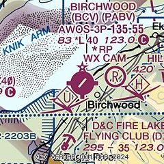
| Sectional chart |
|---|
|
| Airport distance calculator |
|---|
|
|
| Sunrise and sunset |
|---|
|
Times for 27-Jul-2026
| | Local
(UTC-8) | | Zulu
(UTC) |
|---|
| Morning civil twilight | | 04:05 | | 12:05 |
| Sunrise | | 05:18 | | 13:18 |
| Sunset | | 22:51 | | 06:51 |
| Evening civil twilight | | 00:04 | | 08:04 |
|
| Current date and time |
|---|
| Zulu (UTC) | 27-Jul-2026 23:46:51 |
|---|
| Local (UTC-8) | 27-Jul-2026 15:46:51 |
|---|
|
| METAR |
|---|
| PABV | 272256Z AUTO 31004KT 10SM BKN110 20/12 A2973 RMK AO2 SLP067 T02000122 $
|
PAFR
10nm SW | 272255Z AUTO 29004KT 10SM BKN100 21/10 A2973 RMK AO2 SLP068 T02130101 $
|
PAED
13nm SW | 272255Z 02004KT 10SM -RA BKN090 BKN130 20/11 A2972 RMK AO2A SLP060 PCPN VERY LIGHT P0000 T02010113 $
|
PAMR
15nm SW | 272253Z 35003KT 10SM BKN090 OVC110 20/10 A2973 RMK AO2 SLP067 T02000100
|
PAAQ
16nm NE | 272253Z 14012KT 10SM BKN095 BKN110 19/07 A2973 RMK AO2 SLP069 T01890072 $
|
PALH
19nm SW | 272253Z 18010G20KT 10SM FEW080 BKN090 OVC110 19/08 A2974 RMK AO2 RAB04E14 SLP071 P0000 T01890078
|
|
| TAF |
|---|
PAED
13nm SW | 270500Z 2705/2811 24005KT 9999 FEW080 BKN120 QNH2970INS BECMG 2711/2712 24006KT 9999 FEW045 BKN060 OVC085 QNH2967INS BECMG 2723/2724 19005KT 9999 -RA SCT030 OVC050 QNH2974INS TX18/2722Z TN12/2714Z
|
PAAQ
16nm NE | 271125Z 2712/2812 VRB04KT P6SM SCT100 BKN150 FM271800 14006KT P6SM VCSH BKN050 FM272100 16007KT P6SM -SHRA OVC045 FM272300 15010G20KT P6SM VCSH SCT025 OVC060 FM280800 09005KT 6SM -RA OVC025
|
|
| NOTAMs |
|---|
NOTAMs are issued by the DoD/FAA and will open in a separate window not controlled by AirNav.
|
|

