FAA INFORMATION EFFECTIVE 27 NOVEMBER 2025
Location
| FAA Identifier: | PHN |
| Lat/Long: | 42-54-39.4510N 082-31-43.8590W
42-54.657517N 082-31.730983W
42.9109586,-82.5288497
(estimated) |
| Elevation: | 650.1 ft. / 198.2 m (surveyed) |
| Variation: | 07W (1985) |
| From city: | 5 miles SW of PORT HURON, MI |
| Time zone: | UTC -5 (UTC -4 during Daylight Saving Time) |
| Zip code: | 48074 |
Airport Operations
| Airport use: | Open to the public |
| Activation date: | 11/1951 |
| Control tower: | no |
| ARTCC: | CLEVELAND CENTER |
| FSS: | LANSING FLIGHT SERVICE STATION |
| NOTAMs facility: | PHN (NOTAM-D service available) |
| Attendance: | 0800-1700
UNATNDD MAJOR HOLS. |
| Wind indicator: | lighted |
| Segmented circle: | yes |
| Lights: | ACTVT MALSR RWY 04; REIL RWY 22, 10, & 28; PAPI RWY 10 & 28; HIRL RWY 04/22; MIRL RWY 10/28 - CTAF. PAPI RWY 04 & 22 OPR CONSLY. |
| Beacon: | white-green (lighted land airport)
Operates sunset to sunrise. |
| Landing fee: | yes, COML & CORPORATE LDG FEE WAIVED WITH FUEL PURCHASE. |
| International operations: | international airport of entry |
Airport Communications
| CTAF/UNICOM: | 123.05 |
| WX AWOS-3: | 118.375 (810-364-7787) |
| SELFRIDGE APPROACH: | 119.6 |
| SELFRIDGE DEPARTURE: | 119.6 |
- APCH/DEP SVC PRVDD BY CLEVELAND ARTCC (ZOB) ON FREQS 126.525/285.525 (ALGONAC RCAG) WHEN SELFRIDGE APCH CTL CLSD.
Nearby radio navigation aids
| NDB name | | Hdg/Dist | | Freq | | Var | | ID |
|---|
| PHURN | | 043/5.0 | | 332 | | 07W | | PH | .--. .... |
Airport Services
| Fuel available: | 100LL JET-A+ |
| Parking: | hangars and tiedowns |
| Airframe service: | MAJOR |
| Powerplant service: | MAJOR |
| Bottled oxygen: | NONE |
| Bulk oxygen: | NONE |
Runway Information
Runway 4/22
| Dimensions: | 5104 x 100 ft. / 1556 x 30 m |
| Surface: | asphalt/grooved, in good condition |
| Weight bearing capacity: | | Single wheel: | 40.0 | | Double wheel: | 55.0 | | Double tandem: | 90.0 |
|
| Runway edge lights: | high intensity |
| RUNWAY 4 | | RUNWAY 22 |
| Latitude: | 42-54.277845N | | 42-54.956280N |
| Longitude: | 082-32.119095W | | 082-31.444805W |
| Elevation: | 639.8 ft. | | 649.5 ft. |
| Traffic pattern: | left | | left |
| Runway heading: | 043 magnetic, 036 true | | 223 magnetic, 216 true |
| Markings: | precision, in good condition | | precision, in good condition |
| Visual slope indicator: | 4-light PAPI on left (3.00 degrees glide path) | | 4-light PAPI on left (3.00 degrees glide path) |
| Approach lights: | MALSR: 1,400 foot medium intensity approach lighting system with runway alignment indicator lights | | |
| Runway end identifier lights: | no | | yes |
| Touchdown point: | yes, no lights | | yes, no lights |
| Instrument approach: | ILS | | |
| Obstructions: | 49 ft. tree, 592 ft. from runway, 573 ft. left of centerline, 8:1 slope to clear | | 76 ft. tree, 1870 ft. from runway, 78 ft. right of centerline, 21:1 slope to clear |
Runway 10/28
| Dimensions: | 4000 x 75 ft. / 1219 x 23 m |
| Surface: | asphalt, in good condition |
| Weight bearing capacity: | |
| Runway edge lights: | medium intensity |
| RUNWAY 10 | | RUNWAY 28 |
| Latitude: | 42-54.736190N | | 42-54.682075N |
| Longitude: | 082-32.112265W | | 082-31.219570W |
| Elevation: | 643.1 ft. | | 650.1 ft. |
| Traffic pattern: | left | | left |
| Runway heading: | 102 magnetic, 095 true | | 282 magnetic, 275 true |
| Markings: | nonprecision, in fair condition | | nonprecision, in fair condition |
| Visual slope indicator: | 4-light PAPI on left (3.00 degrees glide path) | | 4-light PAPI on left (3.50 degrees glide path) |
| Runway end identifier lights: | yes | | yes |
| Touchdown point: | yes, no lights | | yes, no lights |
| Obstructions: | 71 ft. tree, 1386 ft. from runway, 250 ft. left of centerline, 16:1 slope to clear | | 57 ft. tree, 1173 ft. from runway, 35 ft. right of centerline, 17:1 slope to clear |
Airport Ownership and Management from official FAA records
| Ownership: | Publicly-owned |
| Owner: | SAINT CLAIR COUNTY
201 MCMORRAN BLVD
PORT HURON, MI 48060-4006
Phone 810-364-6890 |
| Manager: | CATHERINE FIORE
177 ASH DR
KIMBALL, MI 48074-4403
Phone 810-364-6890 |
Additional Remarks
| - | DEER & LRG BIRDS ON & INVOF ARPT. |
| - | TSATLC FLTS MUST NTFY US CUST AT 810-985-9541 ONE HR PRIOR TO ENTRY INTO THE US. NTFY US DEPT OF AGRICULTURE AT 810-985-6126 & AMGR 24 HRS PRIOR FOR DISPOSAL OF ACFT INTL TRASH. |
| - | FOR CD CTC SELFRIDGE APCH AT 586-239-5706, WHEN APCH CLSD CTC CLEVELAND ARTCC AT 440-774-0224/0490. |
Instrument Procedures
NOTE: All procedures below are presented as PDF files. If you need a reader for these files, you should download the free Adobe Reader.NOT FOR NAVIGATION. Please procure official charts for flight.
FAA instrument procedures published for use from 27 November 2025 at 0901Z to 25 December 2025 at 0900Z.
IAPs - Instrument Approach Procedures |
|---|
| ILS OR LOC RWY 04 | |
download (273KB) |
| RNAV (GPS) RWY 04 | |
download (235KB) |
| RNAV (GPS) RWY 22 | |
download (209KB) |
| NDB RWY 04 | |
download (229KB) |
| NOTE: Special Alternate Minimums apply | |
download |
| NOTE: Special Take-Off Minimums/Departure Procedures apply | |
download (122KB) |
Other nearby airports with instrument procedures:
57D - Ray Community Airport (19 nm SW)
D98 - Romeo State Airport (21 nm W)
KMTC - Selfridge Air National Guard Base (22 nm SW)
D95 - Dupont/Lapeer Airport (34 nm W)
77G - Marlette Township Airport (34 nm NW)
|
|

Road maps at:
MapQuest
Bing
Google
| Aerial photo |
|---|
WARNING: Photo may not be current or correct

Do you have a better or more recent aerial photo of St Clair County International Airport that you would like to share? If so, please send us your photo.
|
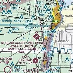
| Sectional chart |
|---|
|
| Airport distance calculator |
|---|
|
|
| Sunrise and sunset |
|---|
|
Times for 07-Dec-2025
| | Local
(UTC-5) | | Zulu
(UTC) |
|---|
| Morning civil twilight | | 07:16 | | 12:16 |
| Sunrise | | 07:48 | | 12:48 |
| Sunset | | 16:55 | | 21:55 |
| Evening civil twilight | | 17:27 | | 22:27 |
|
| Current date and time |
|---|
| Zulu (UTC) | 07-Dec-2025 18:24:40 |
|---|
| Local (UTC-5) | 07-Dec-2025 13:24:40 |
|---|
|
| METAR |
|---|
| KPHN | 071755Z AUTO 32007KT 10SM OVC017 M01/M07 A3005 RMK AO2
|
CYZR
11nm NE | 071753Z AUTO 31008KT 9SM FEW014 BKN035 OVC071 M02/M05 A3004 RMK SLP183
|
|
| TAF |
|---|
CYZR
11nm NE | 071340Z 0714/0802 26005KT 1 1/2SM -SN OVC015 TEMPO 0714/0717 6SM -SN OVC025 FM071700 28008KT 3SM -SN BKN020 OVC040 TEMPO 0717/0720 P6SM -SN SCT020 OVC040 BECMG 0717/0719 32012G22KT FM072000 32012G22KT P6SM BKN030 RMK FCST BASED ON AUTO OBS. NXT FCST BY 072000Z
|
|
| NOTAMs |
|---|
NOTAMs are issued by the DoD/FAA and will open in a separate window not controlled by AirNav.
|
|


