FAA INFORMATION EFFECTIVE 14 MAY 2026
Location
| FAA Identifier: | 57D |
| Lat/Long: | 42-44-12.3056N 082-53-19.8152W
42-44.205093N 082-53.330253W
42.7367516,-82.8888376
(estimated) |
| Elevation: | 632 ft. / 192.6 m (surveyed) |
| Variation: | 06W (1985) |
| From city: | 2 miles SE of RAY, MI |
| Time zone: | UTC -4 (UTC -5 during Standard Time) |
| Zip code: | 48096 |
Airport Operations
| Airport use: | Open to the public |
| Control tower: | no |
| ARTCC: | CLEVELAND CENTER |
| FSS: | LANSING FLIGHT SERVICE STATION |
| NOTAMs facility: | LAN (NOTAM-D service available) |
| Attendance: | 1000-1600 |
| Wind indicator: | lighted |
| Segmented circle: | yes |
| Lights: | ACTVT PAPI RWY 10 & 28; MIRL RWY 10/28 - CTAF. |
| Beacon: | white-green (lighted land airport)
ACTVT ABN - CTAF. |
Airport Communications
| CTAF/UNICOM: | 122.7 |
| SELFRIDGE APPROACH: | 119.6 |
| SELFRIDGE DEPARTURE: | 119.6 |
| WX AWOS-3P at VLL (17 nm SW): | 119.475 (248-288-4649) |
| WX AWOS-3P at PHN (19 nm NE): | 118.375 (810-364-7787) |
- APCH/DEP SVC PRVDD BY CLEVELAND ARTCC (ZOB) ON FREQS 126.525/285.525 (ALGONAC RCAG) WHEN SELFRIDGE APCH CTL CLSD.
Nearby radio navigation aids
| VOR radial/distance | | VOR name | | Freq | | Var |
|---|
| SVMr061/36.9 | | SALEM VORTAC | | 114.30 | | 03W |
| DXOr040/37.9 | | DETROIT VOR/DME | | 113.40 | | 06W |
| NDB name | | Hdg/Dist | | Freq | | Var | | ID |
|---|
| PHURN | | 251/14.4 | | 332 | | 07W | | PH | .--. .... |
Airport Services
| Fuel available: | 100LL
100LL:AVBL H24 SELF SVC VIA CREDIT CARD MACHINE IN TRML BLDG. |
| Parking: | tiedowns |
| Airframe service: | MAJOR |
| Powerplant service: | MAJOR |
| Bottled oxygen: | NONE |
| Bulk oxygen: | NONE |
Runway Information
Runway 10/28
| Dimensions: | 2495 x 60 ft. / 760 x 18 m |
| Surface: | asphalt, in fair condition |
| Runway edge lights: | medium intensity |
| RUNWAY 10 | | RUNWAY 28 |
| Latitude: | 42-44.220167N | | 42-44.234167N |
| Longitude: | 082-53.679500W | | 082-53.122667W |
| Elevation: | 630.0 ft. | | 628.0 ft. |
| Traffic pattern: | left | | left |
| Runway heading: | 094 magnetic, 088 true | | 274 magnetic, 268 true |
| Displaced threshold: | no | | 210 ft. |
| Markings: | basic, in good condition | | basic, in good condition |
| Visual slope indicator: | 2-light PAPI on left (3.00 degrees glide path) | | 2-light PAPI on left |
| Runway end identifier lights: | yes | | no |
| Touchdown point: | yes, no lights | | yes, no lights |
| Obstructions: | none
+8 FT SEASONAL CROPS, 226 FT DIST. | | 43 ft. tree, 757 ft. from runway, 100 ft. right of centerline, 12:1 slope to clear
ROAD, 65 FT DIST. |
Runway 1/19
| Dimensions: | 2202 x 123 ft. / 671 x 37 m |
| Surface: | asphalt/turf, in fair condition |
| Runway edge markings: | 3 FT YELLOW CONES. |
| RUNWAY 1 | | RUNWAY 19 |
| Latitude: | 42-43.998833N | | 42-44.361333N |
| Longitude: | 082-53.244833W | | 082-53.255167W |
| Elevation: | 624.0 ft. | | 632.0 ft. |
| Traffic pattern: | left | | left |
| Runway heading: | 005 magnetic, 359 true | | 185 magnetic, 179 true |
| Displaced threshold: | no | | 140 ft. |
| Markings: | , in fair condition | | basic, in good condition |
| Touchdown point: | yes, no lights | | yes, no lights |
| Obstructions: | 27 ft. tree, 439 ft. from runway, 125 ft. right of centerline, 16:1 slope to clear | | none
APCH RATIO 20:1 TO DTHR. |
Airport Ownership and Management from official FAA records
| Ownership: | Privately-owned |
| Owner: | MACOMB AIRWAYS, INC
59819 INDIAN TRL
RAY, MI 48096-3809
Phone 586-749-9558 |
| Manager: | JOSEPH KOZAR
59819 INDIAN TRL
RAY, MI 48096-3809
Phone 586-999-8665
ADMIN BLDG 586-749-9558. |
Additional Remarks
| - | DEER & LRG BIRDS ON & INVOF ARPT. |
| - | ULTRALIGHT OPS. |
| - | FOR CD CTC SELFRIDGE APCH AT 586-239-5706, WHEN APCH CLSD CTC DETROIT APCH AT 734-955-1404. |
Instrument Procedures
NOTE: All procedures below are presented as PDF files. If you need a reader for these files, you should download the free Adobe Reader.NOT FOR NAVIGATION. Please procure official charts for flight.
FAA instrument procedures published for use from 14 May 2026 at 0901Z to 11 June 2026 at 0900Z.
IAPs - Instrument Approach Procedures |
|---|
| RNAV (GPS)-A | |
download (171KB) |
| NOTE: Special Take-Off Minimums/Departure Procedures apply | |
download (349KB) |
Other nearby airports with instrument procedures:
D98 - Romeo State Airport (5 nm NW)
KMTC - Selfridge Air National Guard Base (8 nm S)
KVLL - Oakland/Troy Airport (17 nm SW)
KPHN - St Clair County International Airport (19 nm NE)
KDET - Coleman A Young Municipal Airport (20 nm S)
|
|

Road maps at:
MapQuest
Bing
Google
| Aerial photo |
|---|
WARNING: Photo may not be current or correct
 Photo taken 10-Oct-2013
looking northwest.
Photo taken 10-Oct-2013
looking northwest.
Do you have a better or more recent aerial photo of Ray Community Airport that you would like to share? If so, please send us your photo.
|
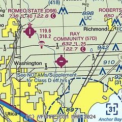
| Sectional chart |
|---|
|
| Airport distance calculator |
|---|
|
|
| Sunrise and sunset |
|---|
|
Times for 08-Jun-2026
| | Local
(UTC-4) | | Zulu
(UTC) |
|---|
| Morning civil twilight | | 05:20 | | 09:20 |
| Sunrise | | 05:54 | | 09:54 |
| Sunset | | 21:07 | | 01:07 |
| Evening civil twilight | | 21:41 | | 01:41 |
|
| Current date and time |
|---|
| Zulu (UTC) | 08-Jun-2026 09:08:20 |
|---|
| Local (UTC-4) | 08-Jun-2026 05:08:20 |
|---|
|
| METAR |
|---|
KMTC
8nm SE | 080855Z AUTO 35004KT 10SM CLR 12/11 A3008 RMK AO2 SLP190 T01210108 53007 $
|
KVLL
17nm SW | 080855Z AUTO 05003KT 10SM CLR 14/12 A3012 RMK AO2
|
KPHN
20nm NE | 080855Z AUTO 00000KT 3SM BR CLR 10/09 A3012 RMK AO2
|
|
| TAF |
|---|
KMTC
8nm SE | 071900Z 0719/0901 03006KT 9999 FEW030 FEW150 QNH2999INS BECMG 0800/0801 04009KT 9999 SKC QNH3000INS TX26/0819Z TN14/0810Z
|
|
| NOTAMs |
|---|
NOTAMs are issued by the DoD/FAA and will open in a separate window not controlled by AirNav.
|
|

