FAA INFORMATION EFFECTIVE 14 MAY 2026
Location
| FAA Identifier: | RHI |
| Lat/Long: | 45-37-51.2420N 089-27-59.8600W
45-37.854033N 089-27.997667W
45.6309006,-89.4666278
(estimated) |
| Elevation: | 1623.3 ft. / 494.8 m (surveyed) |
| Variation: | 03W (2010) |
| From city: | 2 miles SW of RHINELANDER, WI |
| Time zone: | UTC -5 (UTC -6 during Standard Time) |
| Zip code: | 54501 |
Airport Operations
| Airport use: | Open to the public |
| Activation date: | 05/1944 |
| Control tower: | no |
| ARTCC: | MINNEAPOLIS CENTER |
| FSS: | GREEN BAY FLIGHT SERVICE STATION |
| NOTAMs facility: | RHI (NOTAM-D service available) |
| Attendance: | 0600-1900 |
| Wind indicator: | lighted |
| Segmented circle: | no |
| Lights: | HIRL RWY 9/27 PRESET LOW INTST; TO INCR INTST & ACTVT MALSR RWY 09; REIL RWY 15, 27 & 33; PAPI RWY 09 & 27; HIRL RWY 09/27 & 15/33 - CTAF. VASI RWY 15 & PAPI RWY 33 OPR CONSLY. |
| Beacon: | white-green (lighted land airport)
Operates sunset to sunrise. |
| Fire and rescue: | ARFF index A |
| Airline operations: | PPR FOR UNSKED ACR OPNS WITH MORE THAN 9 PSGR SEATS CALL AMGR 715-550-3419 OR 715-550-3417. |
Airport Communications
| CTAF/UNICOM: | 123.0 |
| WX ASOS: | 126.825 (715-793-0008) |
| WX AWOS-3 at TKV (17 nm SW): | 118.250 (715-453-5716) |
| WX AWOS-3 at EGV (20 nm NE): | 118.325 (715-479-1465) |
- APCH/DEP SVC PRVDD BY MINNEAPOLIS ARTCC ON FREQS 133.65/281.5 (RHINELANDER RCAG).
Nearby radio navigation aids
| VOR radial/distance | | VOR name | | Freq | | Var |
|---|
| RHI at field | | RHINELANDER VOR/DME | | 115.05 | | 02E |
| NDB name | | Hdg/Dist | | Freq | | Var | | ID |
|---|
| ARSHA | | 091/6.4 | | 272 | | 03W | | RH | .-. .... |
Airport Services
| Fuel available: | 100LL JET-A
A:SELF SVC FUEL ABVL H24.
100LL:SELF SVC FUEL ABVL H24. |
| Parking: | hangars and tiedowns |
| Airframe service: | MAJOR |
| Powerplant service: | MAJOR |
| Bottled oxygen: | NONE |
| Bulk oxygen: | NONE |
Runway Information
Runway 9/27
| Dimensions: | 6800 x 150 ft. / 2073 x 46 m |
| Surface: | concrete/grooved, in good condition |
| Weight bearing capacity: | | Single wheel: | 100.0 | | Double wheel: | 130.0 | | Double tandem: | 230.0 |
|
| Runway edge lights: | high intensity |
| RUNWAY 9 | | RUNWAY 27 |
| Latitude: | 45-37.817750N | | 45-37.851298N |
| Longitude: | 089-29.196315W | | 089-27.602460W |
| Elevation: | 1623.3 ft. | | 1599.2 ft. |
| Traffic pattern: | left | | left |
| Runway heading: | 091 magnetic, 088 true | | 271 magnetic, 268 true |
| Declared distances: | TORA:6799 TODA:6799 ASDA:6799 LDA:6799 | | TORA:6799 TODA:6799 ASDA:6799 LDA:6799 |
| Markings: | precision, in good condition | | precision, in good condition |
| Visual slope indicator: | 4-light PAPI on left (3.00 degrees glide path) | | 4-light PAPI on left (3.00 degrees glide path) |
| Approach lights: | MALSR: 1,400 foot medium intensity approach lighting system with runway alignment indicator lights | | |
| Runway end identifier lights: | no | | yes |
| Touchdown point: | yes, no lights | | yes, no lights |
| Instrument approach: | ILS | | |
Runway 15/33
| Dimensions: | 5201 x 100 ft. / 1585 x 30 m |
| Surface: | asphalt, in fair condition |
| Weight bearing capacity: | | Single wheel: | 90.0 | | Double wheel: | 130.0 | | Double tandem: | 230.0 |
|
| Runway edge lights: | high intensity |
| RUNWAY 15 | | RUNWAY 33 |
| Latitude: | 45-38.239905N | | 45-37.518938N |
| Longitude: | 089-27.800920W | | 089-27.144032W |
| Elevation: | 1597.4 ft. | | 1611.2 ft. |
| Traffic pattern: | left | | left |
| Runway heading: | 150 magnetic, 147 true | | 330 magnetic, 327 true |
| Declared distances: | TORA:5201 TODA:5201 ASDA:5201 LDA:5201 | | TORA:5201 TODA:5201 ASDA:5201 LDA:5201 |
| Markings: | nonprecision, in good condition | | nonprecision, in good condition |
| Visual slope indicator: | 4-box VASI on left (3.75 degrees glide path) | | 4-light PAPI on left (3.00 degrees glide path) |
| Runway end identifier lights: | yes | | yes |
| Touchdown point: | yes, no lights | | yes, no lights |
| Obstructions: | 75 ft. tree, 1740 ft. from runway, 200 ft. right of centerline, 20:1 slope to clear | | 30 ft. tree, 1145 ft. from runway, 160 ft. left of centerline, 31:1 slope to clear |
Airport Ownership and Management from official FAA records
| Ownership: | Publicly-owned |
| Owner: | RHINELANDER & ONEIDA CO.
3375 AIRPORT ROAD
RHINELANDER, WI 54501
Phone 715-365-3416 |
| Manager: | MATTHEW LEITNER
3375 AIRPORT RD
RHINELANDER, WI 54501
Phone 715-365-3418 |
Additional Remarks
| A39-09/27 | PCR VALUE: 390/R/B/W/T |
| A39-15/33 | PCR VALUE: 380/F/B/X/T |
| - | BIRDS & COYOTE ON & INVOF ARPT. |
| - | FOR CD IF UNA TO CTC ON FSS FREQ, CTC MINNEAPOLIS ARTCC AT 651-463-5588. |
| - | SFC CONDS NOT MONTRD BTWN 0000 - 0500 HRS. |
Instrument Procedures
NOTE: All procedures below are presented as PDF files. If you need a reader for these files, you should download the free Adobe Reader.NOT FOR NAVIGATION. Please procure official charts for flight.
FAA instrument procedures published for use from 14 May 2026 at 0901Z to 11 June 2026 at 0900Z.
IAPs - Instrument Approach Procedures |
|---|
| ILS OR LOC RWY 09 **CHANGED** | |
download (287KB) |
| RNAV (GPS) RWY 09 **CHANGED** | |
download (260KB) |
| RNAV (GPS) RWY 15 **CHANGED** | |
download (273KB) |
| RNAV (GPS) RWY 27 **CHANGED** | |
download (250KB) |
| RNAV (GPS) RWY 33 **CHANGED** | |
download (287KB) |
| NOTE: Special Alternate Minimums apply | |
download (139KB) |
| NOTE: Special Take-Off Minimums/Departure Procedures apply | |
download (483KB) |
Other nearby airports with instrument procedures:
KTKV - Tomahawk Regional Airport (17 nm SW)
KEGV - Eagle River Union Airport (20 nm NE)
KARV - Lakeland Airport/Noble F. Lee Memorial Field (21 nm NW)
Y55 - Crandon/Steve Conway Municipal Airport (24 nm E)
KRRL - Merrill Municipal Airport (28 nm S)
|
|

Road maps at:
MapQuest
Bing
Google
| Aerial photo |
|---|
WARNING: Photo may not be current or correct
 Photo by Laurie Probst
Photo taken 22-Sep-2007
Photo by Laurie Probst
Photo taken 22-Sep-2007
Do you have a better or more recent aerial photo of Rhinelander/Oneida County Airport that you would like to share? If so, please send us your photo.
|
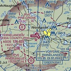
| Sectional chart |
|---|
|
CAUTION: Diagram may not be current

| Airport distance calculator |
|---|
|
|
| Sunrise and sunset |
|---|
|
Times for 22-May-2026
| | Local
(UTC-5) | | Zulu
(UTC) |
|---|
| Morning civil twilight | | 04:45 | | 09:45 |
| Sunrise | | 05:20 | | 10:20 |
| Sunset | | 20:29 | | 01:29 |
| Evening civil twilight | | 21:04 | | 02:04 |
|
| Current date and time |
|---|
| Zulu (UTC) | 22-May-2026 17:18:02 |
|---|
| Local (UTC-5) | 22-May-2026 12:18:02 |
|---|
|
| METAR |
|---|
| KRHI | 221653Z AUTO 11019G24KT 10SM CLR 16/M02 A3021 RMK AO2 PK WND 11026/1616 SLP234 T01611017
|
KTKV
17nm SW | 221655Z AUTO 12009G15KT 10SM CLR 17/M01 A3020 RMK AO2 T01711006 PWINO
|
KEGV
19nm NE | 221635Z AUTO 10008KT 10SM CLR 16/M05 A3023 RMK AO2 T01591051
|
|
| TAF |
|---|
| KRHI | 221131Z 2212/2312 12007KT P6SM BKN100 FM221400 12010G18KT P6SM SCT120 FM222000 12011G21KT P6SM BKN090 FM231100 13007G16KT P6SM BKN030
|
|
| NOTAMs |
|---|
NOTAMs are issued by the DoD/FAA and will open in a separate window not controlled by AirNav.
|
|


