FAA INFORMATION EFFECTIVE 14 MAY 2026
Location
| FAA Identifier: | RHV |
| Lat/Long: | 37-19-58.3000N 121-49-11.3000W
37-19.971667N 121-49.188333W
37.3328611,-121.8198056
(estimated) |
| Elevation: | 135.4 ft. / 41.3 m (surveyed) |
| Variation: | 16E (1975) |
| From city: | 4 miles SE of SAN JOSE, CA |
| Time zone: | UTC -7 (UTC -8 during Standard Time) |
| Zip code: | 95122 |
Airport Operations
| Airport use: | Open to the public |
| Activation date: | 09/1942 |
| Control tower: | yes |
| ARTCC: | OAKLAND CENTER |
| FSS: | OAKLAND FLIGHT SERVICE STATION |
| NOTAMs facility: | RHV (NOTAM-D service available) |
| Attendance: | 0800-1800 |
| Wind indicator: | lighted |
| Segmented circle: | yes |
| Lights: | WHEN ATCT CLSD ACTVT REIL RWYS 13L & 31R; MIRL RWY 13L/31R - CTAF. PAPI RWYS 13L, 31R & 31L OPR CONSLY. |
| Beacon: | white-green (lighted land airport)
Operates sunset to sunrise. |
Airport Communications
| CTAF: | 119.8 |
| UNICOM: | 122.95 |
| ATIS: | 125.2 |
| REID-HILLVIEW GROUND: | 121.65 [0700-2200] |
| REID-HILLVIEW TOWER: | 119.8 ;RWY 13L/31R 126.1 ;RWY 13R/31L [0700-2200] |
| NORCAL APPROACH: | 120.1 133.95 134.5 |
| NORCAL DEPARTURE: | 121.3 |
| IC: | 120.1 |
| WX ASOS at SJC (5 nm W): | PHONE 408-969-0838 |
| WX AWOS-3PT at NUQ (12 nm NW): | 124.175 (650-386-0655) |
| WX AWOS-3P at E16 (18 nm SE): | 118.350 (408-918-7724) |
- EMERG FREQ 121.5 NOT AVBL AT ATCT.
- SAID IN USE. OPERATE TRANSPONDERS WITH ALTITUDE REPORTING MODE AND ADS-B (IF EQUIPPED) ENABLED ON ALL AIRPORT SURFACES.
Nearby radio navigation aids
| VOR radial/distance | | VOR name | | Freq | | Var |
|---|
| SJCr097/6.5 | | SAN JOSE VOR/DME | | 114.10 | | 16E |
| OSIr082/22.3 | | WOODSIDE VOR/DME | | 113.90 | | 17E |
| OAKr124/30.4 | | OAKLAND VOR/DME | | 116.80 | | 17E |
| SFOr106/31.5 | | SAN FRANCISCO VOR/DME | | 115.80 | | 17E |
Airport Services
| Fuel available: | A G100 UL94
UL94:100LL UNAVBL. |
| Parking: | hangars and tiedowns |
| Airframe service: | MAJOR |
| Powerplant service: | MAJOR |
| Bottled oxygen: | LOW |
| Bulk oxygen: | LOW |
Runway Information
Runway 13L/31R
| Dimensions: | 3100 x 75 ft. / 945 x 23 m |
| Surface: | asphalt, in fair condition |
| Weight bearing capacity: | |
| Runway edge lights: | medium intensity |
| RUNWAY 13L | | RUNWAY 31R |
| Latitude: | 37-20.190822N | | 37-19.783512N |
| Longitude: | 121-49.356103W | | 121-48.970077W |
| Elevation: | 123.6 ft. | | 135.4 ft. |
| Traffic pattern: | left | | right |
| Runway heading: | 127 magnetic, 143 true | | 307 magnetic, 323 true |
| Displaced threshold: | 499 ft. | | 410 ft. |
| Markings: | nonprecision, in good condition | | nonprecision, in fair condition |
| Visual slope indicator: | 4-light PAPI on right (4.00 degrees glide path) | | 4-light PAPI on left (4.00 degrees glide path) |
| Runway end identifier lights: | yes | | yes |
| Touchdown point: | yes, no lights | | yes, no lights |
| Obstructions: | 47 ft. tree, 920 ft. from runway, 205 ft. left of centerline, 15:1 slope to clear
RY 13L APCH RATIO TO DSPLCD THLD 30:1. | | 16 ft. road, 200 ft. from runway
& 31L +6 FT FENCE 150 FT FROM THR; RY 31R & 31L ROAD EDGE 155 FT FROM THR. |
Runway 13R/31L
| Dimensions: | 3099 x 75 ft. / 945 x 23 m |
| Surface: | asphalt, in fair condition |
| Weight bearing capacity: | |
| Runway edge lights: | RWY 13R/31L UNLGTD. |
| RUNWAY 13R | | RUNWAY 31L |
| Latitude: | 37-20.160902N | | 37-19.753777N |
| Longitude: | 121-49.405502W | | 121-49.019558W |
| Elevation: | 122.8 ft. | | 133.9 ft. |
| Traffic pattern: | right | | left |
| Runway heading: | 127 magnetic, 143 true | | 307 magnetic, 323 true |
| Displaced threshold: | 499 ft. | | 409 ft. |
| Markings: | nonprecision, in fair condition | | nonprecision, in good condition |
| Visual slope indicator: | | | 4-light PAPI on left (4.00 degrees glide path) |
| Runway end identifier lights: | no | | no |
| Touchdown point: | yes, no lights | | yes, no lights |
| Obstructions: | 55 ft. tree, 1016 ft. from runway, 75 ft. left of centerline, 14:1 slope to clear
RY 13R APCH RATIO TO DSPLCD THLD 27:1. | | 18 ft. road, 200 ft. from runway
APCH RATIO TO DSPLCD THR 33:1 |
Airport Ownership and Management from official FAA records
| Ownership: | Publicly-owned |
| Owner: | COUNTY OF SANTA CLARA
2500 CUNNINGHAM AVE
SAN JOSE, CA 95148
Phone 408-929-7700
DIRECTOR OF AIRPORTS, ERIC PETERSON |
| Manager: | ERIC PETERSON
2500 CUNNINGHAM AVE.
SAN JOSE, CA 95148
Phone 408-918-7700 |
Additional Remarks
| - | RY 31R CALM WIND RY WHEN ATCT CLSD. |
| - | NO PURE JET AND NO SURPLUS MIL ACFT EXCEPT THOSE MEETING FAR 36 NOISE CRITERIA. |
| - | NO TURNS BLO 500 FT WHEN LEAVING PATTERN EXCEPT RWY 31R DEPARTURES. AS SOON AS PRACTICABLE AFTER DEPARTURE MAKE A SLIGHT RIGHT TURN TO AVOID SCHOOL ONE HALF MILE OFF DEPARTURE END. |
| - | NO TOUCH & GO LNDGS BTN 2100-0700. |
| - | NO SIMULATED EMERGENCIES IN ARPT TFC AREA. |
| - | BIRDS ON AND INVOF ARPT. |
| - | BE ALERT ALL PILOTS - DO NOT CONFUSE ILLUMINATION FROM STREET LGTS NORTH-EAST OF AND PARALLEL TO RHV RYS THAT COULD BE MISTAKEN FOR RY LGTS. ENSURE PROPER ACTVTN OF PILOT CTLD ARPT SFC LGTG. |
| - | FOR CD WHEN ATCT IS CLSD CTC NORCAL APCH AT 916-361-3748. |
Instrument Procedures
NOTE: All procedures below are presented as PDF files. If you need a reader for these files, you should download the free Adobe Reader.NOT FOR NAVIGATION. Please procure official charts for flight.
FAA instrument procedures published for use from 14 May 2026 at 0901Z to 11 June 2026 at 0900Z.
STARs - Standard Terminal Arrivals |
|---|
| POINT REYES THREE | |
download (222KB) |
| POINT REYES THREE | |
download (222KB) |
IAPs - Instrument Approach Procedures |
|---|
| RNAV (GPS) RWY 13L | |
download (394KB) |
| RNAV (GPS) Y RWY 31R | |
download (445KB) |
| RNAV (GPS) Z RWY 31R | |
download (454KB) |
|
|---|
| DECOT ONE (OBSTACLE) (RNAV) | |
download (153KB) |
| HENCE ONE (OBSTACLE) | |
2 pages:
[1] [2] (568KB) |
| NOTE: Special Take-Off Minimums/Departure Procedures apply | |
download (347KB) |
Other nearby airports with instrument procedures:
KSJC - Norman Y Mineta San Jose International Airport (5 nm W)
KNUQ - Moffett Federal Airfield (12 nm NW)
KPAO - Palo Alto Airport (16 nm NW)
E16 - San Martin Airport (18 nm SE)
KLVK - Livermore Municipal Airport (22 nm N)
|
|

Road maps at:
MapQuest
Bing
Google
| Aerial photo |
|---|
WARNING: Photo may not be current or correct
 Photo courtesy of focalflight.com
Photo taken 10-Apr-2015
looking east.
Photo courtesy of focalflight.com
Photo taken 10-Apr-2015
looking east.
Do you have a better or more recent aerial photo of Reid-Hillview Airport of Santa Clara County that you would like to share? If so, please send us your photo.
|
| Sectional chart |
|---|
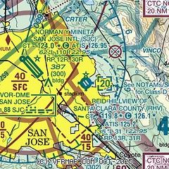
|
CAUTION: Diagram may not be current
 Download PDF
of official airport diagram from the FAA
| Airport distance calculator |
|---|
|
|
| Sunrise and sunset |
|---|
|
Times for 19-May-2026
| | Local
(UTC-7) | | Zulu
(UTC) |
|---|
| Morning civil twilight | | 05:27 | | 12:27 |
| Sunrise | | 05:56 | | 12:56 |
| Sunset | | 20:11 | | 03:11 |
| Evening civil twilight | | 20:41 | | 03:41 |
|
| Current date and time |
|---|
| Zulu (UTC) | 19-May-2026 07:08:20 |
|---|
| Local (UTC-7) | 19-May-2026 00:08:20 |
|---|
|
| METAR |
|---|
| KRHV | 190455Z 31003KT 10SM SKC 21/02 A2997 RMK LAST
|
KSJC
5nm NW | 190653Z 33005KT 10SM CLR 17/09 A2998 RMK AO2 SLP151 T01720089
|
KNUQ
11nm NW | 190655Z AUTO 05003KT 9SM CLR 16/08 A2998 RMK AO2
|
KPAO
16nm NW | 190347Z 33006KT 10SM SKC 19/04 A2995 RMK LAST
|
KE16
18nm SE | 190650Z AUTO 11004KT 10SM CLR 15/02 A3000 RMK AO2
|
|
| TAF |
|---|
KSJC
5nm NW | 190520Z 1906/2006 15003KT P6SM SKC FM191800 32009KT P6SM SKC FM200400 15002KT P6SM SKC
|
|
| NOTAMs |
|---|
NOTAMs are issued by the DoD/FAA and will open in a separate window not controlled by AirNav.
|
|


